Cof Cymru: National Historic Assets of Wales · Wales
No 1 & 2
Carew, Pembrokeshire, Wales
A Grade II listed building in Carew Village, Tenby, Carew, Pembrokeshire, designated on 14 May 1970.
The record
- Designation
- Listed building, Grade II
- Broad class
- Domestic
- Date of designation
- 14 May 1970
- Locality
- Carew Village
- Town
- Tenby
- Community
- Carew
- Unitary authority
- Pembrokeshire
- Country
- Wales
- Coordinates
- 51.69808, -4.82731
- Cadw reference
- 18199
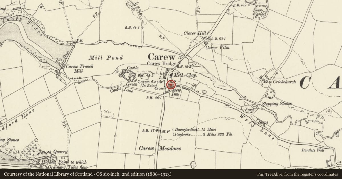
Slide toward Today to fade the historical sheet and see the modern map underneath.
David Rumsey Map Collection, Stanford LibrariesDavid Rumsey Map Collection, Stanford LibrariesDavid Rumsey Map Collection, Stanford LibrariesDavid Rumsey Map Collection, Stanford LibrariesDavid Rumsey Map Collection, Stanford Libraries
5 historical maps cover this location, the earliest the 1636 map "Cornubia : Devonia, Somersetus, Dorcestria, Wiltonia, Glocestria ..." (David Rumsey Map Collection, Stanford Libraries).
Historical maps covering this location
- 1636 · Cornubia : Devonia, Somersetus, Dorcestria, Wiltonia, Glocestria ... (David Rumsey Map Collection, Stanford Libraries)
- 1865 · England and Wales. England No. 6. (David Rumsey Map Collection, Stanford Libraries)
- 1891 · Sheet 10. Ordnance Survey of England and Wales. . (David Rumsey Map Collection, Stanford Libraries)
- 1898 · 228 Haverfordwest (Hills) (David Rumsey Map Collection, Stanford Libraries)
- 1901 · Sheet 13. (David Rumsey Map Collection, Stanford Libraries)
Cadw's description
Location
In Carew village, adjacent to the Carew Inn. There is a white-painted stone wall at the front with a slate coping and neat iron railings, and two large gate-piers.
History
Two C18 cottages, now converted into a single cottage. These were the original nucleus of Picton Terrace, apparently shown on the 1750 estate map. The left cottage was no. 1 and was probably single-fronted. Its door and window have been replaced by a modern slightly canted window. The right cottage was no. 2 and was probably double-fronted. There is a door centrally to it which remains in use for the combined cottage, with a porch.
Exterior
Two storeys, with a range of three windows facing N to the village street. Random rubble masonry painted white. There is a brick chimney in a position central to the original right cottage. There are also end-chimneys of brick, altered when adjacent higher buildings were constructed.
All the upper windows are of 12 panes, with hornless sashes. The left lower window is modern. The other two are nine-pane sash windows in recessed exposed frames. Six-panel door with an open timber porch.
Reason for designation
Listed as C18 cottages retaining some original character and as the historic nucleus of the group known as Picton Terrace.
Nearby in the register
- Old Stable CottageDomesticunder 1 mi
- Carew InnCommercialunder 1 mi
- Castle LodgeDomesticunder 1 mi
- Carew CrossCrossunder 1 mi
Other entries of the same register within about three miles of this one, by straight line.