Cof Cymru: National Historic Assets of Wales · Wales
L-Shaped Agricultural Range at Hen-Ddol
Arthog, Gwynedd, Wales
A Grade II listed building in Friog, Arthog, Gwynedd, designated on 1 February 1995.
The record
- Designation
- Listed building, Grade II
- Broad class
- Agriculture and Subsistence
- Date of designation
- 1 February 1995
- Locality
- Friog
- Community
- Arthog
- Unitary authority
- Gwynedd
- Country
- Wales
- Coordinates
- 52.69126, -4.04632
- Cadw reference
- 15596
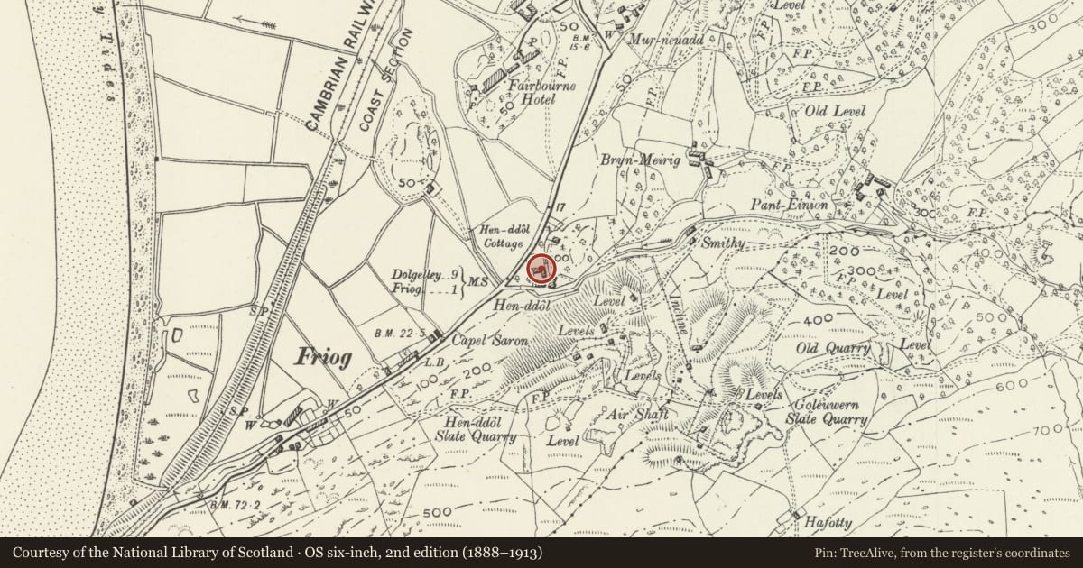
Slide toward Today to fade the historical sheet and see the modern map underneath.
David Rumsey Map Collection, Stanford LibrariesDavid Rumsey Map Collection, Stanford LibrariesDavid Rumsey Map Collection, Stanford LibrariesLlyfrgell Genedlaethol Cymru – The National Library of WalesDavid Rumsey Map Collection, Stanford Libraries
5 historical maps cover this location, the earliest the 1795 map "To Sir Watkin Williams-Wynn Bart ... the map of the six counties of North Wales is most humbly inscribed by his obedient humble servant" (Llyfrgell Genedlaethol Cymru – The National Library of Wales).
Historical maps covering this location
- 1795 · To Sir Watkin Williams-Wynn Bart ... the map of the six counties of North Wales is most… (Llyfrgell Genedlaethol Cymru – The National Library of Wales)
- 1883 · Watershed map England, Wales 3. (David Rumsey Map Collection, Stanford Libraries)
- 1896 · Sheet 7. Ordnance Survey of England and Wales. (David Rumsey Map Collection, Stanford Libraries)
- 1899 · 149 Barmouth (Hills) (David Rumsey Map Collection, Stanford Libraries)
- 1901 · Sheet 9 and 10. (David Rumsey Map Collection, Stanford Libraries)
Cadw's description
Location
Located immediately to the NW of Hen-ddol farmhouse, on the opposite side of the lane; facing converted outbuildings.
Exterior
A second quarter/mid C19 L-shaped agricultural range consisting of a large cart shed with open hay-loft over and single-storey former byre/stable block at right-angles with it. Rubble construction with old slate roofs. The main cart shed and hay-loft range has 4 entrances of varying sizes to the ground floor, the central one a large cart opening and the smaller one to far L blocked; large flat stone lintels. Above, the open hay-loft with 3 large openings under the eaves, that to the L of double-width; plain rubble piers. Large upper loading bay to Fford Hen-ddol gable.
Adjoining at right-angles and stepped-down an earlier byre or stable block with weather coursing at their intersection; construction as before. Entrance to R and square light to L. Short rear roof pitch.
Interior
3 bay main range with rubble dividing wall between first 2 bays of hay-loft; plain trusses with overlapping purlins and some unsquared timbers.
Reason for designation
Included as a good C19 agricultural range, unusual in its cart house and hay-loft arrangement.
Group value with Hen-ddol farmhouse.
Nearby in the register
- Hen-Ddol Farmhouse including attached Outbuilding to N Ffordd HenddolDomesticunder 1 mi
- New InnCommercialunder 1 mi
- Old Toll HouseTransportunder 1 mi
- Hut Circle (and Early Field System) on Bryn SewardUnenclosed hut circleunder 1 mi
Other entries of the same register within about three miles of this one, by straight line.