Cof Cymru: National Historic Assets of Wales · Wales
Whitehouse Cottage
Barry, Vale of Glamorgan, Wales
A Grade II* listed building in The Knap, Barry, Vale of Glamorgan, designated on 7 February 1978.
The record
- Designation
- Listed building, Grade II*
- Broad class
- Domestic
- Date of designation
- 7 February 1978
- Locality
- The Knap
- Town
- Barry
- Community
- Barry
- Unitary authority
- Vale of Glamorgan
- Country
- Wales
- Coordinates
- 51.38921, -3.29031
- Cadw reference
- 13400
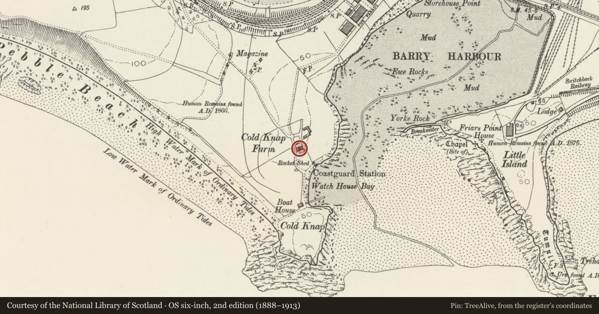
Slide toward Today to fade the historical sheet and see the modern map underneath.
David Rumsey Map Collection, Stanford LibrariesDavid Rumsey Map Collection, Stanford LibrariesDavid Rumsey Map Collection, Stanford LibrariesDavid Rumsey Map Collection, Stanford LibrariesDavid Rumsey Map Collection, Stanford Libraries
5 historical maps cover this location, the earliest the 1636 map "Cornubia : Devonia, Somersetus, Dorcestria, Wiltonia, Glocestria ..." (David Rumsey Map Collection, Stanford Libraries).
Historical maps covering this location
- 1636 · Cornubia : Devonia, Somersetus, Dorcestria, Wiltonia, Glocestria ... (David Rumsey Map Collection, Stanford Libraries)
- 1858 · 20. Bridgewater. (David Rumsey Map Collection, Stanford Libraries)
- 1865 · England and Wales. England No. 6. (David Rumsey Map Collection, Stanford Libraries)
- 1898 · 263 Cardiff (Hills) (David Rumsey Map Collection, Stanford Libraries)
- 1913 · Sheet 110. Cardiff & Mouth of the Severn. (David Rumsey Map Collection, Stanford Libraries)
Cadw's description
Location
To N of Watch Tower and Old Rocket Shed.
History
Facing roughly S, behind front garden bounded by low rubble wall. Formerly known as Cold Knap Farm, or Cole or Coal Farm.
Exterior
Left (W) end of house late C16, originally single unit house with end entry (to W); right (E) end of house added circa 1600, or perhaps earlier (has wall-painting which is said to date from circa 1580). Later 1-storey extension to L, outshut rear (C17 to W, and C18), and porch. Severely damaged by fire circa 1978.
Two storeys, rendered rubble walls, thatched roof, low end chimneys. S front has central doorway with Tudor arch, concealed by thatched entrance porch with stone seat. To L side, at eaves level, 2 small casement windows, at ground level two sash windows. To R of porch, first floor has 2 square sash windows, similar window at ground floor. Single storey extension at W end with slate roof, stack to L hand and window in front wall.
Interior
West ground floor room retains narrow circular stone stair with corbelled roof and original wooden arched doorframe (on N side of fireplace); timber ceiling with 4 plain chamfered beams with half-pyramid and hollow cut stops. E ground floor room retains stone stair with corbelled roof and segmentally arched wooden doorframe on N side of fireplace; 2 chamfered ceiling beams. Beside stair is wall-painting in ochre of female figure in C16 dress holding flowers, said to be Jane Andrew painted on occasion of her marriage in 1580. Roof restored after fire; chamfered purlins with ogee stops on E side of the house form the lintels of the windows.
Reason for designation
Graded II* for exceptional interest of wall-painting, and as the oldest inhabited house in Barry.
Nearby in the register
- Old Rocket StationMaritimeunder 1 mi
- WatchtowerMaritimeunder 1 mi
- Pavilions at Cold Knap Park with adjacent staircasesGardens, Parks and Urban Spacesunder 1 mi
- Knap Roman SiteVillaunder 1 mi
Other entries of the same register within about three miles of this one, by straight line.