Cof Cymru: National Historic Assets of Wales · Wales
Ty Cwm Tawel Anti-invasion Defences
Llanpumsaint, Carmarthenshire, Wales
A scheduled monument in Llanpumsaint, Carmarthenshire, recorded as Anti Invasion Defence Site (Post Medieval/Modern).
The record
- Designation
- Scheduled monument
- Site type
- Anti Invasion Defence Site
- Period
- Post Medieval/Modern
- Date of designation
- 6 March 2008
- Community
- Llanpumsaint
- Unitary authority
- Carmarthenshire
- Country
- Wales
- Coordinates (centre of the scheduled area)
- 51.90815, -4.34264
- SAM number
- CM372
- Cadw record number
- 960
Slide toward Today to fade the historical sheet and see the modern map underneath.
David Rumsey Map Collection, Stanford LibrariesDavid Rumsey Map Collection, Stanford LibrariesDavid Rumsey Map Collection, Stanford LibrariesDavid Rumsey Map Collection, Stanford LibrariesDavid Rumsey Map Collection, Stanford Libraries
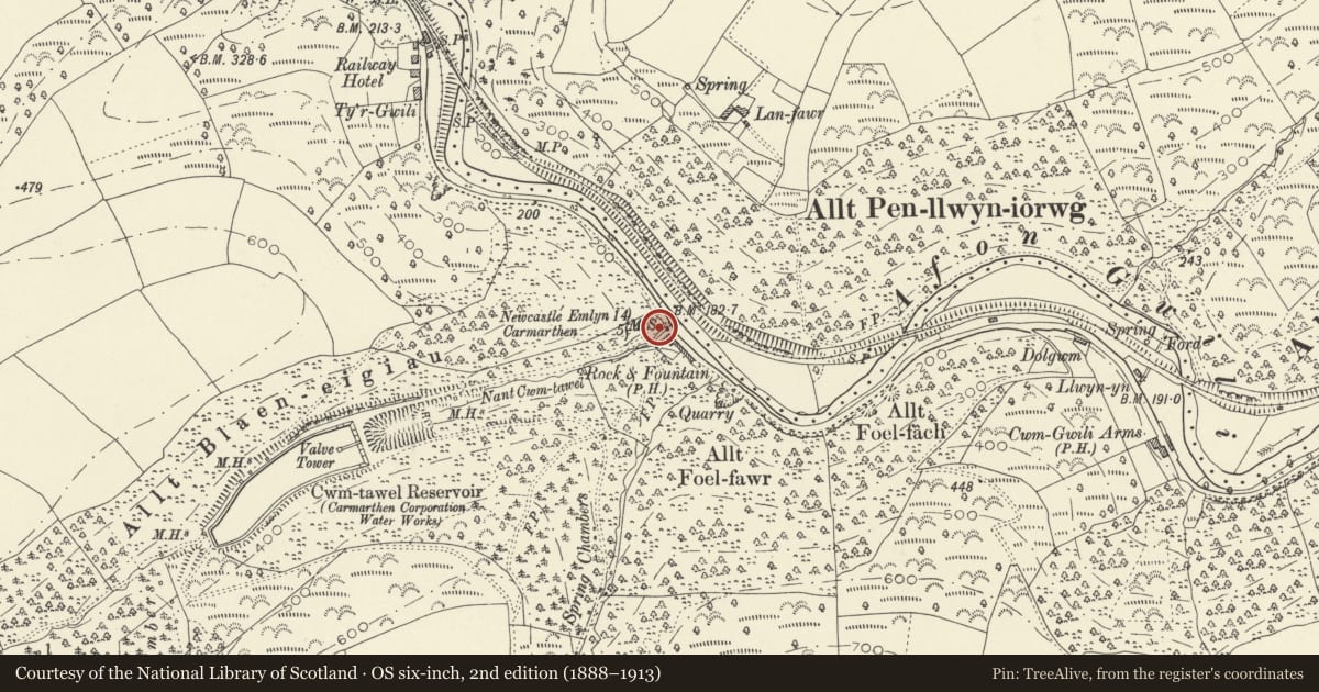
5 historical maps cover this location, the earliest the 1608 map "(13) Cambriae Typus." (David Rumsey Map Collection, Stanford Libraries).
Historical maps covering this location
- 1608 · (13) Cambriae Typus. (David Rumsey Map Collection, Stanford Libraries)
- 1860 · 41. Caermathen. (David Rumsey Map Collection, Stanford Libraries)
- 1891 · Sheet 10. Ordnance Survey of England and Wales. . (David Rumsey Map Collection, Stanford Libraries)
- 1898 · 211 Newcastle Emlyn (Hills) (David Rumsey Map Collection, Stanford Libraries)
- 1901 · Sheet 14. (David Rumsey Map Collection, Stanford Libraries)
Cadw's description
Summary description and reason for designation
The following provides a general description of the Scheduled Monument.
The monument, also known by the name Rock and Fountain after the former public house, consists of anti-invasion defences, dating to the early period of World War II (AD 1940-41), that formed part of Western Command's Carmarthen Stop Line, which ran from Llangranog via Cynwyl Elfed and Carmarthen to the mouth of the Afon Tywi. The defences are located at the confluence of Nant Cwm Tawel with the Afon Gwili. Here, they defend the strategically important narrowing of the Gwili valley where the road, railway and river ran in parallel. Located adjacent to a reservoir and pumping house, the structures may also have defended a public water supply. A pillbox (Item 'A') defends the track towards the reservoir, as well as the trunk road to the NW and SE. A pumping house (Item 'B') immediately to the NE was fortified by the addition of a strongpoint. A double row of vertical steel girders (Item 'C') to the N across the Afon Gwili and railway embankment provided an anti-tank obstacle. A second double row of vertical steel girders (Item 'D') to the W across Nant Cwm Tawel provided an additional anti-tank obstacle. A barbed wire entanglement (Item 'E') survives to the N of Item 'C'.
The monument is of national importance for its potential to enhance our knowledge of World War II anti-invasion practices. The monument is well preserved and its importance is further enhanced by the group value of the individual structures. It is an important relic of actions taken against the perceived threat of a German invasion from Ireland. It retains significant archaeological potential, with a strong probability of the presence of associated archaeological features and deposits.
The areas scheduled comprise the remains described and areas around them within which related evidence may be expected to survive. Each scheduled area is irregular in shape on plan.
Nearby in the register
- Knightsford FarmDomesticunder 1 mi
- Defended Enclosure 300m W of Pen y GarPromontory Fort - inland1 mi
- Garn-Fawr Tumuli & EnclosureRound Barrow1 mi
- Cynwyl Elfed Anti-invasion DefencesAnti Invasion Defence Site1 mi
Other entries of the same register within about three miles of this one, by straight line.