Cof Cymru: National Historic Assets of Wales · Wales
Cynwyl Elfed Anti-invasion Defences
Cynwyl Elfed, Carmarthenshire, Wales
A scheduled monument in Cynwyl Elfed, Carmarthenshire, recorded as Anti Invasion Defence Site (Post Medieval/Modern).
The record
- Designation
- Scheduled monument
- Site type
- Anti Invasion Defence Site
- Period
- Post Medieval/Modern
- Date of designation
- 21 January 2008
- Community
- Cynwyl Elfed
- Unitary authority
- Carmarthenshire
- Country
- Wales
- Coordinates (centre of the scheduled area)
- 51.91937, -4.36607
- SAM number
- CM374
- Cadw record number
- 958
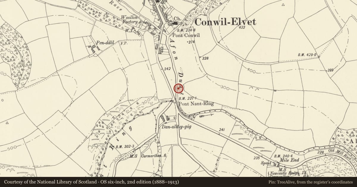
Slide toward Today to fade the historical sheet and see the modern map underneath.
David Rumsey Map Collection, Stanford LibrariesDavid Rumsey Map Collection, Stanford LibrariesDavid Rumsey Map Collection, Stanford LibrariesDavid Rumsey Map Collection, Stanford LibrariesDavid Rumsey Map Collection, Stanford Libraries
5 historical maps cover this location, the earliest the 1608 map "(13) Cambriae Typus." (David Rumsey Map Collection, Stanford Libraries).
Historical maps covering this location
- 1608 · (13) Cambriae Typus. (David Rumsey Map Collection, Stanford Libraries)
- 1860 · 41. Caermathen. (David Rumsey Map Collection, Stanford Libraries)
- 1891 · Sheet 10. Ordnance Survey of England and Wales. . (David Rumsey Map Collection, Stanford Libraries)
- 1898 · 211 Newcastle Emlyn (Hills) (David Rumsey Map Collection, Stanford Libraries)
- 1901 · Sheet 14. (David Rumsey Map Collection, Stanford Libraries)
Cadw's description
Summary description and reason for designation
The following provides a general description of the Scheduled Monument.
The monument consists of anti-invasion defences, dating to the early period of World War II (AD 1940-41), that formed part of Western Command's Carmarthen Stop Line, which ran N from the mouth of the Afon Tywi to Carmarthen, thence to Cynwyl Elfed, Rhos, Henllan, Llangeler via Rhydlewis to Llangranog. The line formed part of the defences for anticipated operations against Milford Haven, Port Talbot and Swansea. The pillboxes are located on the south side of Cynwyl Elfed. Item A is a standard Type 24 pillbox, which faces southwest covering the Nant Ring valley. Item B is a Norcon type pillbox located at the junction of an old drove road with the A484 trunk road. Item C is a Norcon type pillbox located in the Nant Ring valley. Item D is a standard Type 24 pillbox and faces southwest across the Afon Duad valley.
The monument is of national importance for its potential to enhance our knowledge of World War II anti-invasion practices. The monument is well preserved and is an important relic of actions taken against the perceived threat of a German invasion from Ireland. The two Norcon pillboxes are the only known examples to survive inland in Wales. The monument retains significant archaeological potential, with a strong probability of the presence of associated archaeological features and deposits. The importance of the monument is enhanced further by its group value with the anti-invasion defences at Ty Cwm Tawel located 2Km to the southeast (scheduled ancient monument CM372).
The areas scheduled comprise the remains described and areas around within which related evidence may be expected to survive. Scheduled area A is centred on Item A (SN 37358 27080). It is rectangular and measures 15m north to south by 13.5m transversely. Area B is centred on Item B (SN 37377 27054). It is triangular in shape and measures 16m north to south by 15m transversely. Area C is centred on Item C (SN 37263 27091). It is circular in shape and measures 15m in diameter. Area D is centred on Item D (SN 37500 27312). It is rectangular in shape and measures 15m northwest to southeast by 12m transversely.
Nearby in the register
- Lychgate to Church of St CynwylReligious, Ritual and Funeraryunder 1 mi
- Church of Saint CynwylReligious, Ritual and Funeraryunder 1 mi
- Gates and railings to Bethel Calvinistic Methodist ChapelReligious, Ritual and Funeraryunder 1 mi
- Bethel Calvinistic Methodist ChapelReligious, Ritual and Funeraryunder 1 mi
Other entries of the same register within about three miles of this one, by straight line.