Cof Cymru: National Historic Assets of Wales · Wales
Gate Tower Block of Plas Castell
Denbigh, Denbighshire, Wales
A Grade II listed building in Denbigh - Castle, Denbigh, Denbighshire, designated on 2 February 1981.
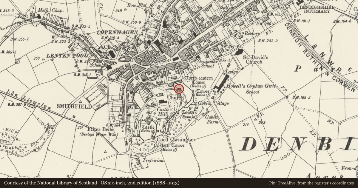
The record
- Designation
- Listed building, Grade II
- Broad class
- Domestic
- Date of designation
- 2 February 1981
- Locality
- Denbigh - Castle
- Community
- Denbigh
- Unitary authority
- Denbighshire
- Country
- Wales
- Coordinates
- 53.18234, -3.41853
- Cadw reference
- 972
Slide toward Today to fade the historical sheet and see the modern map underneath.
David Rumsey Map Collection, Stanford LibrariesLlyfrgell Genedlaethol Cymru – The National Library of WalesDavid Rumsey Map Collection, Stanford LibrariesDavid Rumsey Map Collection, Stanford LibrariesDavid Rumsey Map Collection, Stanford Libraries
5 historical maps cover this location, the earliest the 1608 map "(13) Cambriae Typus." (David Rumsey Map Collection, Stanford Libraries).
Historical maps covering this location
- 1608 · (13) Cambriae Typus. (David Rumsey Map Collection, Stanford Libraries)
- 1795 · To Sir Watkin Williams-Wynn Bart ... the map of the six counties of North Wales is most… (Llyfrgell Genedlaethol Cymru – The National Library of Wales)
- 1830 · V.3:11-15:XV. Britisches Reich. A. Kon: England. b. Frstenthum Wales: Shire: 37-40 (David Rumsey Map Collection, Stanford Libraries)
- 1883 · Watershed map England, Wales 3. (David Rumsey Map Collection, Stanford Libraries)
- 1901 · Sheet 9 and 10. (David Rumsey Map Collection, Stanford Libraries)
Cadw's description
Location
Located on a commanding, elevated site immediately to the E of Leicester's church, within the Old Town; adjoining the rear, service range at Plas Castell
History
Gatehouse and clock tower, built onto Plas Castell in 1882 for Emily Augusta Fazackerly, formerly of Barnwell Abbey, Somerset. The tower was built by J Simon Roberts and incorporated a clock which was subsequently removed to Barnwell church. The foundation stone is inscribed: "This stone was laid by E A Fazackerley on the 17th day of Jany. 1882".
Exterior
Large gate and clock tower of three-and-a-half storeys, in Italian Gothic style. Of red brick construction with bands of yellow brick and some limestone dressings. The tower is rectangular with 2-bay sides and 3-bay main faces, the central bays broader; the outer bays are defined by applied, off-set brick shafts which spring from corbels at first-floor level and rise through the battlemented upper stage as crenellated turrets. Large central archway to the lower stage, with 4 centred head in moulded brick; blind, sunk panels flank this on each side. The first floor has a 2-light window with narrow arched lights recessed within a larger arch. Above this is an oculus within a limestone frame with heraldic, pointed-arched top; the oculus originally contained the clock face. The outer bays have pointed-arched lancets on each storey, as do the sides; small-pane glazing with intersecting heads. Battlemented upper stage with off-set dentilations and limestone crenellations. The central bay rises up half a stage further and terminates with similar battlements and off-set corner turrets; faux machicolations with 3-light vertical slit window below. A limestone foundation stone is visible at the bottom R.
Interior
The interior was not inspected at the time of survey.
Reason for designation
Listed for its special interest as a striking Victorian clock and gate tower in a prominent location showing robust Italian Gothic character with strong military references.
Group value with Plas Castell.
Nearby in the register
- Aedicular Gothic Gazebo and associated garden steps at Peacock HouseGardens, Parks and Urban Spacesunder 1 mi
- Leicester's Church (Remains)Religious, Ritual and Funeraryunder 1 mi
- Plas Castell, also known as Castle HouseDomesticunder 1 mi
- Bryn Orme, including terrace revetment wallsDomesticunder 1 mi
Other entries of the same register within about three miles of this one, by straight line.