Cof Cymru: National Historic Assets of Wales · Wales
33 Quay Street
Carmarthen, Carmarthenshire, Wales
A Grade II listed building in Carmarthen, Carmarthenshire, designated on 19 May 1981.
The record
- Designation
- Listed building, Grade II
- Broad class
- Domestic
- Date of designation
- 19 May 1981
- Community
- Carmarthen
- Unitary authority
- Carmarthenshire
- Country
- Wales
- Coordinates
- 51.85589, -4.30728
- Cadw reference
- 9523
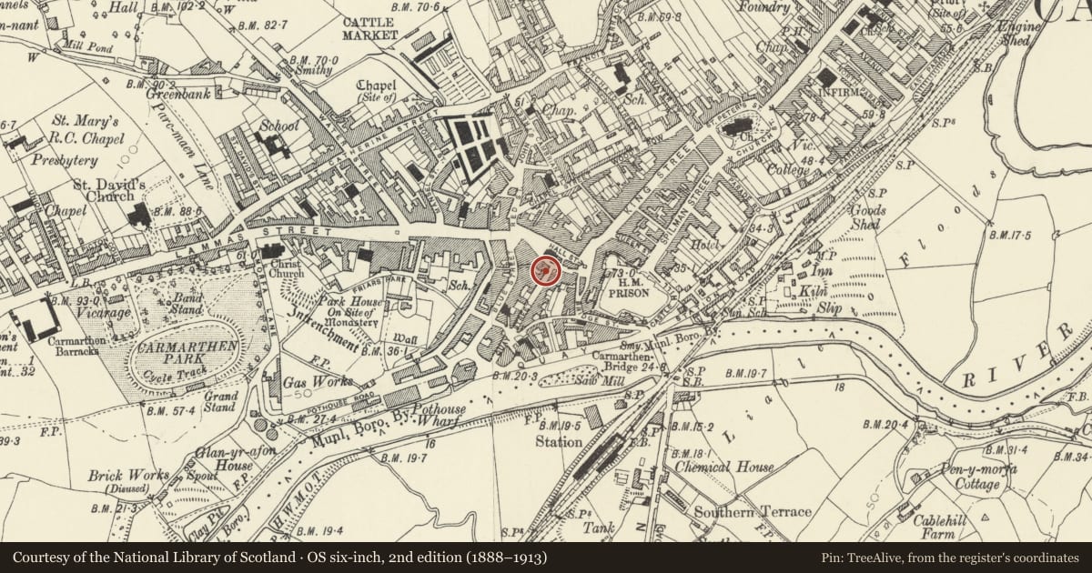
Slide toward Today to fade the historical sheet and see the modern map underneath.
David Rumsey Map Collection, Stanford LibrariesDavid Rumsey Map Collection, Stanford LibrariesDavid Rumsey Map Collection, Stanford LibrariesDavid Rumsey Map Collection, Stanford LibrariesDavid Rumsey Map Collection, Stanford Libraries
5 historical maps cover this location, the earliest the 1636 map "Cornubia : Devonia, Somersetus, Dorcestria, Wiltonia, Glocestria ..." (David Rumsey Map Collection, Stanford Libraries).
Historical maps covering this location
- 1636 · Cornubia : Devonia, Somersetus, Dorcestria, Wiltonia, Glocestria ... (David Rumsey Map Collection, Stanford Libraries)
- 1860 · 41. Caermathen. (David Rumsey Map Collection, Stanford Libraries)
- 1891 · Sheet 10. Ordnance Survey of England and Wales. . (David Rumsey Map Collection, Stanford Libraries)
- 1898 · 229 Carmarthen (Hills) (David Rumsey Map Collection, Stanford Libraries)
- 1901 · Sheet 14. (David Rumsey Map Collection, Stanford Libraries)
Cadw's description
Location
Situated some 10m SW of junction with St Mary's Street.
History
Terraced house probably of early to mid C18 origins, altered in C19. Marked on 1834 map. In later C20, before 1980, offices of Alex Gordon Partnership, architects. Restored in 1995 with loss of interiors including a good C18 staircase, offices 2002. The steep roof and stone end stacks suggest an similar date to Nos 2 and 3 opposite, though the building is to a much more modest or vernacular scale.
Exterior
Terraced house, steep slate roof with same eaves level as No 32, and large rubble stone external end stacks. Two storeys with attic and cellar, irregular facade of 4 bays. Two roof lights. Three 12-pane sashes to first floor, no window in right bay. Ground floor has no window in left bay, 16-pane sash in second bay, door in third and 12-pane sash in fourth. Two steps up to four-panel door. Raised plinth. Rewindowed since 1981 when there was a cellar opening with boarded doors beneath right window, now just small vent.
Rear wall of rubble stone is curved, with close eaves, C20 concrete tiles, and 4-pane sash each floor to right.
Interior
Interior all altered. In 1981 there was a mid to later C18 staircase with turned middle section similar to those in Spring Gardens.
Reason for designation
Included, notwithstanding loss of interior features, as a terraced house of character, but earlier to mid C18 origins in the best Georgian street in Carmarthen.
Nearby in the register
- 34 Quay StreetDomesticunder 1 mi
- 32 Quay StreetDomesticunder 1 mi
- 17 Guildhall SquareCommercialunder 1 mi
- 2 Quay StreetDomesticunder 1 mi
Other entries of the same register within about three miles of this one, by straight line.