Cof Cymru: National Historic Assets of Wales · Wales
Gates, piers & railings fronting Bathafarn Chapel & Bathafarn House
Ruthin, Denbighshire, Wales
A Grade II listed building in Market Street & Wynnstay Road, Ruthin, Denbighshire, designated on 30 December 2005.
The record
- Designation
- Listed building, Grade II
- Broad class
- No class recorded
- Date of designation
- 30 December 2005
- Locality
- Market Street & Wynnstay Road
- Town
- Ruthin
- Community
- Ruthin
- Unitary authority
- Denbighshire
- Country
- Wales
- Coordinates
- 53.11537, -3.30892
- Cadw reference
- 87330
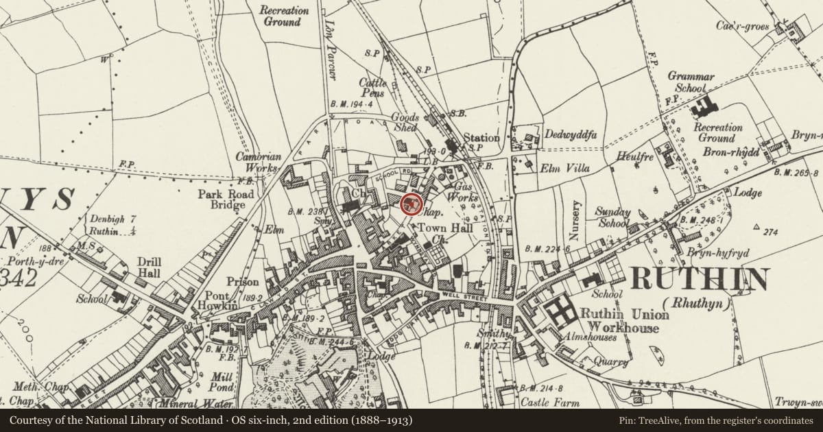
Slide toward Today to fade the historical sheet and see the modern map underneath.
David Rumsey Map Collection, Stanford LibrariesDavid Rumsey Map Collection, Stanford LibrariesDavid Rumsey Map Collection, Stanford LibrariesLlyfrgell Genedlaethol Cymru – The National Library of WalesDavid Rumsey Map Collection, Stanford Libraries
5 historical maps cover this location, the earliest the 1795 map "To Sir Watkin Williams-Wynn Bart ... the map of the six counties of North Wales is most humbly inscribed by his obedient humble servant" (Llyfrgell Genedlaethol Cymru – The National Library of Wales).
Historical maps covering this location
- 1795 · To Sir Watkin Williams-Wynn Bart ... the map of the six counties of North Wales is most… (Llyfrgell Genedlaethol Cymru – The National Library of Wales)
- 1883 · Watershed map England, Wales 3. (David Rumsey Map Collection, Stanford Libraries)
- 1898 · 108 Flint (Hills) (David Rumsey Map Collection, Stanford Libraries)
- 1898 · 108 Flint (Outline) (David Rumsey Map Collection, Stanford Libraries)
- 1901 · Sheet 9 and 10. (David Rumsey Map Collection, Stanford Libraries)
Cadw's description
Location
Boundary wall and railings fronting Bathafarn Chapel and Bathafarn House, with gateway to each property from Market Street.
History
Gates and railings probably contemporary with Bathafarn Chapel, a Wesleyan chapel built in 1869 by Richard Owens of Liverpool, and with the same detail. The iron work was made by the Phoenix Works, Rhuddlan.
Exterior
Low brick boundary wall with chamfered sandstone coping, which steps down from L to R, following the slope of the road. End piers, gate piers and pier at boundary of properties, of dressed sandstone with chamfered angles and brick panels, pyramidal capstones with moulded edges including incised circles and zig-zag decoration. Those to gateway of house read 'Bathafarn House', those to chapel are surmounted by former gas lamps, with short barley twist columns. Double cast iron gates to chapel, single gate to house, each in 3 bands with ogee decoration and scrollwork, and fleur de lis finials. A plaque is attached to the chapel gates reading 'John Williams / Phoenix Works / Rhuddlan'. To house, railings on flanking walls are the same as on the gates. To chapel, plain railings with attached scrollwork motifs, and fleur-de-lis finials. To R end, boundary wall returns to Mount Street as a plain red brick wall with triangular-section terracotta coping.
Reason for designation
Listed as well-detailed gates, piers and railings retaining their C19 character, and for group value with Bathafarn Chapel and Bathafarn House.
Nearby in the register
- Bathafarn HouseNo class recordedunder 1 mi
- Bathafarn Wesleyan Methodist ChapelReligious, Ritual and Funeraryunder 1 mi
- War MemorialNo class recordedunder 1 mi
- Christ's HospitalNo class recordedunder 1 mi
Other entries of the same register within about three miles of this one, by straight line.