Cof Cymru: National Historic Assets of Wales · Wales
The Old Wool Market
Haverfordwest, Pembrokeshire, Wales
A Grade II listed building in Haverfordwest, Pembrokeshire, designated on 14 December 1971.
The record
- Designation
- Listed building, Grade II
- Broad class
- Commercial
- Date of designation
- 14 December 1971
- Town
- Haverfordwest
- Community
- Haverfordwest
- Unitary authority
- Pembrokeshire
- Country
- Wales
- Coordinates
- 51.80051, -4.96682
- Cadw reference
- 87036
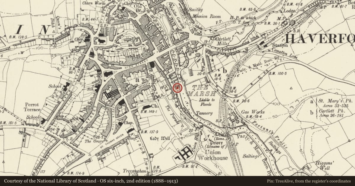
Slide toward Today to fade the historical sheet and see the modern map underneath.
David Rumsey Map Collection, Stanford LibrariesDavid Rumsey Map Collection, Stanford LibrariesDavid Rumsey Map Collection, Stanford LibrariesDavid Rumsey Map Collection, Stanford LibrariesDavid Rumsey Map Collection, Stanford Libraries
5 historical maps cover this location, the earliest the 1608 map "(13) Cambriae Typus." (David Rumsey Map Collection, Stanford Libraries).
Historical maps covering this location
- 1608 · (13) Cambriae Typus. (David Rumsey Map Collection, Stanford Libraries)
- 1636 · Cornubia : Devonia, Somersetus, Dorcestria, Wiltonia, Glocestria ... (David Rumsey Map Collection, Stanford Libraries)
- 1891 · Sheet 10. Ordnance Survey of England and Wales. . (David Rumsey Map Collection, Stanford Libraries)
- 1898 · 228 Haverfordwest (Hills) (David Rumsey Map Collection, Stanford Libraries)
- 1901 · Sheet 13. (David Rumsey Map Collection, Stanford Libraries)
Cadw's description
Location
Situated with gable ends to Quay Street and to the quay just N of the Bristol Trader inn.
History
Late C18 former wool market later used as a warehouse, converted to offices c. 2000. There are arches each end and two on S side, possibly originally open. A plaque of 1777 referring to the building of the Quay by J. Argust may also date the building.
Exterior
Warehouse, rubble stone with slate close eaved roof. Long building of two storeys and loft, with six-bay sides. E end to the quay has modern bargeboards, a big round arched former entry now glazed, with stone voussoirs, a first floor loading door, now glazed, with concrete head under sill of loft loading door with timber lintel. One window to each side of first floor door, with brick heads and stone keystones. Windows are part-louvred over 4-pane casements. S side has six first floor casement pair windows with cemented brick heads, and ground floor with two broad arched former entries alternated with two inserted big square headed entries, cemented around and with modern glazing. The arch to left has recessed rubble stone blocking, the arch to right flush rubble blocking of some antiquity, with inset blocked door with stone voussoirs. To right of first floor windows is a stone plaque: 'This Quay was rebuilt at the expense of this Corpn in the MAYORALTY of Wm Moore Esq 1777', signed below '? Argust'. Gable end to Quay St has modern bargeboards, stone steps up to left to adjoining warehouse and to a first floor side door. Loft door in gable with brick head, first floor door with brick head, altered with one side in brick, with window each side with brick heads. Ground floor big arched entry with stone voussoirs. Modern glazing to openings. Rear N wall has four upper windows with brick heads.
Interior
Interior altered as offices.
Reason for designation
Included for its special historic interest as a large late C18 warehouse, former wool market.
Nearby in the register
- The Candle StoresCommercialunder 1 mi
- The Bristol Trader InnCommercialunder 1 mi
- The Old QuayMaritimeunder 1 mi
- The Old GranaryCommercialunder 1 mi
Other entries of the same register within about three miles of this one, by straight line.