Cof Cymru: National Historic Assets of Wales · Wales
Bryn Teg
Llanarth, Monmouthshire, Wales
A Grade II listed building in Llanarth, Monmouthshire, designated on 27 January 2006.
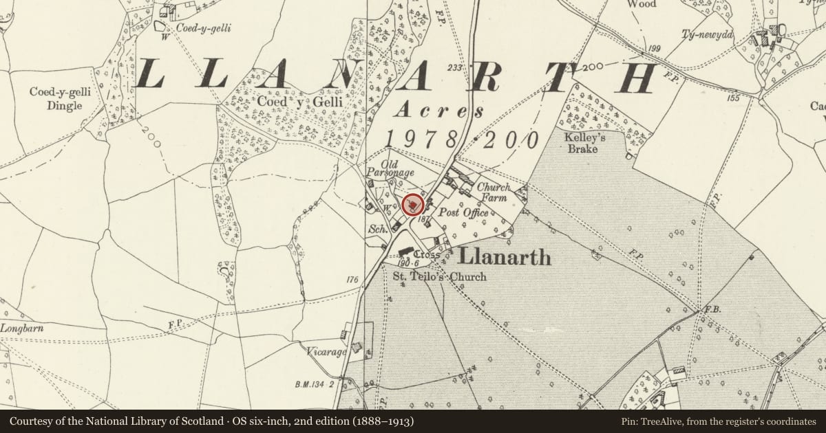
The record
- Designation
- Listed building, Grade II
- Broad class
- Domestic
- Date of designation
- 27 January 2006
- Locality
- Llanarth
- Community
- Llanarth
- Unitary authority
- Monmouthshire
- Country
- Wales
- Coordinates
- 51.79469, -2.90648
- Cadw reference
- 85515
Slide toward Today to fade the historical sheet and see the modern map underneath.
David Rumsey Map Collection, Stanford LibrariesDavid Rumsey Map Collection, Stanford LibrariesDavid Rumsey Map Collection, Stanford LibrariesDavid Rumsey Map Collection, Stanford LibrariesDavid Rumsey Map Collection, Stanford Libraries
5 historical maps cover this location, the earliest the 1608 map "(13) Cambriae Typus." (David Rumsey Map Collection, Stanford Libraries).
Historical maps covering this location
- 1608 · (13) Cambriae Typus. (David Rumsey Map Collection, Stanford Libraries)
- 1636 · Cornubia : Devonia, Somersetus, Dorcestria, Wiltonia, Glocestria ... (David Rumsey Map Collection, Stanford Libraries)
- 1830 · V.3:11-15:XV.Britisches Reich. A. Kon: England. a. England ab sich: Shire:15-17, 33 (David Rumsey Map Collection, Stanford Libraries)
- 1895 · Sheet 11. Ordnance Survey of England and Wales. (David Rumsey Map Collection, Stanford Libraries)
- 1901 · Sheet 14. (David Rumsey Map Collection, Stanford Libraries)
Cadw's description
Location
In Llanarth village, opposite the post-office, set back from the street behind a low stone wall with simple cock-and-hen copings.
History
Pair of Llanarth estate cottages, probably c1880.
Exterior
Pair of cottages in High-Victorian Gothic style, designed asymmetrically to read as a single dwelling. Flemishbond brickwork with some stone dressings, mainly tiled roofs with scallop bands, though Welsh slate on rear wing. 2 storeyed with attics, comprising long gabled range to right (no 2), with shorter range to left with half-hipped roof and rear wing (no 1). Main elevation facing the street is asymmetrically composed with tall gable to right, and smaller asymmetrical dormer gable to its left. Central doorway left of main gable (to no 1) with split boarded door with prominent hinges, and 4-light casement window (renewed), both under long lean-to porch or veranda, carried on timber brackets. Gable to right has 4-light mullioned and transomed window to ground floor, with shallow arched head; continuous string course above it, then 3-light casement to first floor, with brick relieving arch with stone kneelers and key; 2-light casement with simple brick arched head in attic. Return elevation to right has doorway with overlight towards centre, and windows similar to those of the front gable (4-light mullioned and transom with arched head with stone dressings to ground floor, 2-light casement with relieving arch above). 2 brick ridge stacks. Left hand gable return is rendered and has mainly modern windows; rear wing is separately roofed in Welsh slate and has brick stack on ridge.
Interior
Not inspected.
Reason for designation
Listed as a well-preserved pair of High Victorian estate cottages, boldly composed and detailed, forming part of a long series of building by the Llanarth estate, and contributing to the architectural character of the village.
Nearby in the register
- Former Post OfficeCommercialunder 1 mi
- Telephone Call-box (01873 840412)Communicationsunder 1 mi
- Church of Saint TeiloReligious, Ritual and Funeraryunder 1 mi
- Hen BersondyDomesticunder 1 mi
Other entries of the same register within about three miles of this one, by straight line.