Cof Cymru: National Historic Assets of Wales · Wales
Station House at Tan-y-bwlch Station
Maentwrog, Gwynedd, Wales
A Grade II listed building in Tan-y-bwlch, Maentwrog, Gwynedd, designated on 25 February 2005.
The record
- Designation
- Listed building, Grade II
- Broad class
- No class recorded
- Date of designation
- 25 February 2005
- Locality
- Tan-y-bwlch
- Community
- Maentwrog
- Unitary authority
- Gwynedd
- Country
- Wales
- Coordinates
- 52.95460, -4.01121
- Cadw reference
- 84020
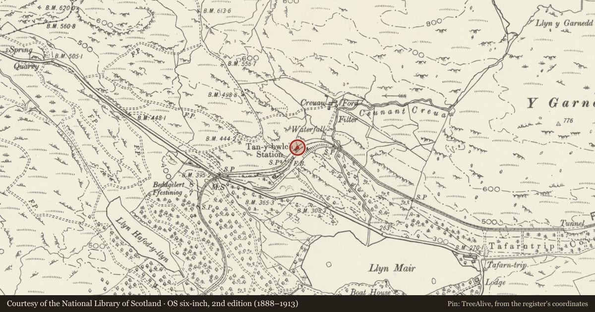
Slide toward Today to fade the historical sheet and see the modern map underneath.
David Rumsey Map Collection, Stanford LibrariesDavid Rumsey Map Collection, Stanford LibrariesDavid Rumsey Map Collection, Stanford LibrariesLlyfrgell Genedlaethol Cymru – The National Library of WalesDavid Rumsey Map Collection, Stanford Libraries
5 historical maps cover this location, the earliest the 1795 map "To Sir Watkin Williams-Wynn Bart ... the map of the six counties of North Wales is most humbly inscribed by his obedient humble servant" (Llyfrgell Genedlaethol Cymru – The National Library of Wales).
Historical maps covering this location
- 1795 · To Sir Watkin Williams-Wynn Bart ... the map of the six counties of North Wales is most… (Llyfrgell Genedlaethol Cymru – The National Library of Wales)
- 1883 · Watershed map England, Wales 3. (David Rumsey Map Collection, Stanford Libraries)
- 1896 · Sheet 7. Ordnance Survey of England and Wales. (David Rumsey Map Collection, Stanford Libraries)
- 1899 · 119 Snowdon (Hills) (David Rumsey Map Collection, Stanford Libraries)
- 1901 · Sheet 9 and 10. (David Rumsey Map Collection, Stanford Libraries)
Cadw's description
Location
Set back from the NE side of the B4410 on the northern approach to the small hamlet of Tan-y-bwlch.
History
In 1832 an Act of Parliament was obtained for the construction of the line between the slate quarries at Blaenau Ffestiniog down to the shipping wharfs at the new town of Porthmadoc. Passenger traffic started in 1865 and the line prospered for many years, but by the end of the century the decreasing demand for slate combined with the transfer of traffic via the newer links to Blaenau by L&NWR and GWR railways, led to a substantially reduced revenue for the Ffestiniog railway. Its use continued to be depleted until passenger services stopped in September 1939, and slate traffic in 1946. Passenger traffic was eventually resumed, and a service to Tan y bwlch station was restored in 1958. Whilst other buildings and structures at the station have been altered or rebuilt, the station house remains unchanged.
Exterior
Single storey station house built of roughly coursed rubble masonry; decorative slate roof with advanced eaves and verges, shaped barge boards and rectangular ridge stacks with capping. The principal elevation faces the railway, the central doorway under a slate roofed porch canopy; flanking windows are timber casements of 3-lights, 2 to each end of the range.
Interior
The interior was not inspected at the time of the survey (June/July 2003).
Reason for designation
Listed as a little altered early C19 station house of interest as an integral part of the Festiniog railway.
Nearby in the register
- Railway Bridge to W of Tan-y-bwlch StationTransportunder 1 mi
- Tafarn TripDomesticunder 1 mi
- Lodge to E of Plas Tan y BwlchDomesticunder 1 mi
- Former servant's quarters to rear of Plas Tan-y-bwlchNo class recordedunder 1 mi
Other entries of the same register within about three miles of this one, by straight line.