Cof Cymru: National Historic Assets of Wales · Wales
The Cardiff Arms PH and attached wing
Usk, Monmouthshire, Wales
A Grade II listed building in Usk, Monmouthshire, designated on 30 April 2004.
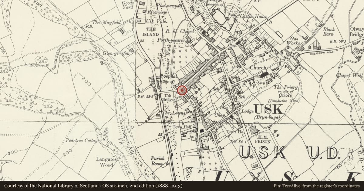
The record
- Designation
- Listed building, Grade II
- Broad class
- Commercial
- Date of designation
- 30 April 2004
- Locality
- Usk
- Town
- Usk
- Community
- Usk
- Unitary authority
- Monmouthshire
- Country
- Wales
- Coordinates
- 51.70188, -2.90604
- Cadw reference
- 82784
Slide toward Today to fade the historical sheet and see the modern map underneath.
David Rumsey Map Collection, Stanford LibrariesDavid Rumsey Map Collection, Stanford LibrariesDavid Rumsey Map Collection, Stanford LibrariesDavid Rumsey Map Collection, Stanford LibrariesDavid Rumsey Map Collection, Stanford Libraries
5 historical maps cover this location, the earliest the 1636 map "Cornubia : Devonia, Somersetus, Dorcestria, Wiltonia, Glocestria ..." (David Rumsey Map Collection, Stanford Libraries).
Historical maps covering this location
- 1636 · Cornubia : Devonia, Somersetus, Dorcestria, Wiltonia, Glocestria ... (David Rumsey Map Collection, Stanford Libraries)
- 1637 · The fourth table of England. Cornub. Devonia, Somerset etc. (David Rumsey Map Collection, Stanford Libraries)
- 1830 · V.3:11-15:XV.Britisches Reich. A. Kon: England. a. England ab sich: Shire:15-17, 33 (David Rumsey Map Collection, Stanford Libraries)
- 1895 · Sheet 11. Ordnance Survey of England and Wales. (David Rumsey Map Collection, Stanford Libraries)
- 1913 · Sheet 102. Newport. (David Rumsey Map Collection, Stanford Libraries)
Cadw's description
Location
A corner site, with elevation also to Bridge Street, close to the Bridge.
History
Part of the late C19 development at the SW end of Bridge Street. In an area to rear was formerly a Japanning works in the last quarter of the C18.
Exterior
Late Victorian PH. Built of red brick with render, brick and terracotta dressings, painted yellow; rear gable end is stone; slate roof with decorative ridge tiles incorporating three gabled dormers. Frontage to New Market Street of 4 bays, curved corner bay, and 2 bays to Bridge Street. New Market Street frontage has 2 dormers with small-pane upper sash windows with large scrolled side brackets; first floor has 3 segmental-headed margin glazed sashes with moulded painted surrounds and large intervening decorative quatrefoil panels, the storey defined by decorative moulded string courses above and below; ground floor has round-arched windows with painted surrounds and keystone, another quatrefoil panel and bar windows with etched glass; doorway centre left with plain fanlight and double panelled doors. Painted plinth. Corner bay has a very tall tiered tower-like parapet scrolled at sides; a wide recessed panel with painted inn sign at first floor level; blank ground floor. Bridge Street elevation similar to New Market Street, one dormer, a 2-window first floor range, ground floor window and second door. Attached to side of new Market Street frontage is a single storey shed range of limewashed rubble with slate roof and central double doors with painted sign 'Cardiff Arms' above; window inserted to right, a former smithy.
Reason for designation
Listed for Group Value with other listed buildings at the W end of Bridge Street and N end of New Market Street.
Nearby in the register
- 67 Bridge StreetCommercialunder 1 mi
- 59 Bridge StreetCommercialunder 1 mi
- 5 New Market StreetDomesticunder 1 mi
- Merlin CottageDomesticunder 1 mi
Other entries of the same register within about three miles of this one, by straight line.