Cof Cymru: National Historic Assets of Wales · Wales
40 Rating Row
Beaumaris, Isle of Anglesey, Wales
A Grade II listed building in Beaumaris, Isle of Anglesey, designated on 20 February 1978.
The record
- Designation
- Listed building, Grade II
- Broad class
- Domestic
- Date of designation
- 20 February 1978
- Locality
- Beaumaris
- Town
- Beaumaris
- Community
- Beaumaris
- Unitary authority
- Isle of Anglesey
- Country
- Wales
- Coordinates
- 53.26443, -4.09402
- Cadw reference
- 5652
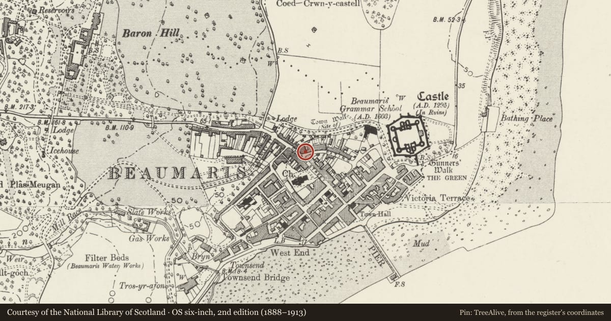
Slide toward Today to fade the historical sheet and see the modern map underneath.
David Rumsey Map Collection, Stanford LibrariesDavid Rumsey Map Collection, Stanford LibrariesDavid Rumsey Map Collection, Stanford LibrariesDavid Rumsey Map Collection, Stanford LibrariesDavid Rumsey Map Collection, Stanford Libraries
5 historical maps cover this location, the earliest the 1883 map "Watershed map England, Wales 3." (David Rumsey Map Collection, Stanford Libraries).
Historical maps covering this location
- 1883 · Watershed map England, Wales 3. (David Rumsey Map Collection, Stanford Libraries)
- 1896 · Sheet 7. Ordnance Survey of England and Wales. (David Rumsey Map Collection, Stanford Libraries)
- 1899 · 94 Beaumaris (Hills) (David Rumsey Map Collection, Stanford Libraries)
- 1901 · Sheet 9 and 10. (David Rumsey Map Collection, Stanford Libraries)
- 1919 · Sheet 41. Anglesey. (David Rumsey Map Collection, Stanford Libraries)
Cadw's description
Location
Fronting the street in a block of buildings near the NW end of Rating Row.
History
Probably an C18 house, whose interior detail suggests a vernacular plan of kitchen and parlour. It was remodelled in the C19 when the present fenestration was inserted and the ground plan was probably altered to include a central entrance hall. The house is shown on the 1829 town plan.
Exterior
A 2½-storey 4-window Georgian house of scribed roughcast, slate roof and roughcast end stacks. The entrance, to the R of centre, has a panelled door, of which the upper panels are fielded. Of a former doorcase, only the pediment has survived. On the R-hand side is a 12-pane window. To the L of the entrance are paired 12-pane horned sash windows, and a single similar window further L. The upper storey has three 12-pane hornless sash windows.
The rear is whitened render and has 2 single-storey flat-roofed projections. A 16-pane horizontal-sliding sash window lights the stair, and 2 gabled roof dormers have replacement windows. A gabled 1½-storey rear wing on the R side, shown on the 1829 plan, has replacement windows.
Interior
The room on the L side was probably originally a kitchen, and has a fireplace with timber lintel, and a joist-beam ceiling. The room on the R side, probably the parlour, has a C19 Tudor fireplace surround, and a stop-chamfered spine beam. A simple C19 straight stair is behind the room on the L.
Reason for designation
Listed for its special architectural interest as a late Georgian house retaining C19 character and detail, with earlier origin, and for its contribution to the historical integrity of Rating Row.
Nearby in the register
- 42 Rating RowDomesticunder 1 mi
- Victoria HouseDomesticunder 1 mi
- Ty AbelDomesticunder 1 mi
- Melvin CottageNo class recordedunder 1 mi
Other entries of the same register within about three miles of this one, by straight line.