Cof Cymru: National Historic Assets of Wales · Wales
Tanyrardd
Aberdaron, Gwynedd, Wales
A Grade II listed building in Rhiw, Pwllheli, Aberdaron, Gwynedd, designated on 19 October 1971.
The record
- Designation
- Listed building, Grade II
- Broad class
- Domestic
- Date of designation
- 19 October 1971
- Locality
- Rhiw
- Town
- Pwllheli
- Community
- Aberdaron
- Unitary authority
- Gwynedd
- Country
- Wales
- Coordinates
- 52.82982, -4.61489
- Cadw reference
- 4248
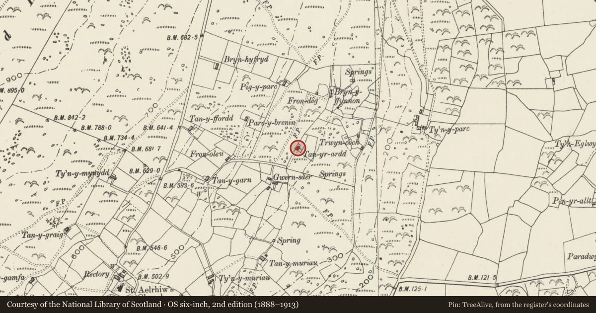
Slide toward Today to fade the historical sheet and see the modern map underneath.
David Rumsey Map Collection, Stanford LibrariesDavid Rumsey Map Collection, Stanford LibrariesDavid Rumsey Map Collection, Stanford LibrariesDavid Rumsey Map Collection, Stanford LibrariesDavid Rumsey Map Collection, Stanford Libraries
5 historical maps cover this location, the earliest the 1608 map "(13) Cambriae Typus." (David Rumsey Map Collection, Stanford Libraries).
Historical maps covering this location
- 1608 · (13) Cambriae Typus. (David Rumsey Map Collection, Stanford Libraries)
- 1830 · V.3:11-15:XV. Britisches Reich. A. Kon: England. b. Frstenthum Wales: Shire: 37-40 (David Rumsey Map Collection, Stanford Libraries)
- 1883 · Watershed map England, Wales 3. (David Rumsey Map Collection, Stanford Libraries)
- 1899 · 134 Pwllheli (Hills) (David Rumsey Map Collection, Stanford Libraries)
- 1901 · Sheet 9 and 10. (David Rumsey Map Collection, Stanford Libraries)
Cadw's description
Location
Situated on common land NW of Rhiw church, on N side of track from Gwern-saer to Bryn-ffynnon.
History
Earlier croglofft cottage, part of the group of cottages on the slope below the road including Tanyffordd, Tanygarn, Fronoleu, Pigyparc, Gwernsaer and Frondeg that represent the later phase of the encroachment process onto common land. This cottage still has the much bigger kitchen chimney, a feature that is not found in the mid C19 cottages, like Frondeg. Built before 1813, and marked on 1842 Rhiw Tithe map as owned by the Rev William Ellis, occupied by Salmon Rowlands, with 1 acre (0.4ha).
Exterior
Cottage, rubble stone whitewashed to front with roof of large slates and stone end-wall stacks with dripstones and pyramid capping. Large square stack to left end. Single storey, double fronted with C20 plate glass windows in original openings and C20 stable-door. Previous windows described in 1971 as one sash, one casement. Lean-to on left end with asbestos-sheet roof, rubble stone with one window and full-height door.
Interior
Retains elements of original layout with modern partial partition on the line of an original partition dividing the interior into a principal heated room, and a smaller room under the surviving croglofft. Main room has stone chimney breast with timber beam spanning original opening (now reduced with later fireplace inserted).
Reason for designation
Included as one of the best preserved of the group of croglofft cottages built on common land NW of Rhiw, a compact and largely complete group of commons-encroachment cottages on this still uncultivated hillside. As a group they form one of the best examples regionally of the process of settling marginal land in the C19.
Nearby in the register
- Outbuilding at GwernsaerDomesticunder 1 mi
- GwernsaerDomesticunder 1 mi
- Pigsty at FrondegDomesticunder 1 mi
- FrondegDomesticunder 1 mi
Other entries of the same register within about three miles of this one, by straight line.