Cof Cymru: National Historic Assets of Wales · Wales
Church of the Holy Trinity
Trellech United, Monmouthshire, Wales
A Grade II listed building in Whitebrook, Monmouth, Trellech United, Monmouthshire, designated on 28 February 2001.
The record
- Designation
- Listed building, Grade II
- Broad class
- Religious, Ritual and Funerary
- Date of designation
- 28 February 2001
- Locality
- Whitebrook
- Town
- Monmouth
- Community
- Trellech United
- Unitary authority
- Monmouthshire
- Country
- Wales
- Coordinates
- 51.75568, -2.67698
- Cadw reference
- 24917
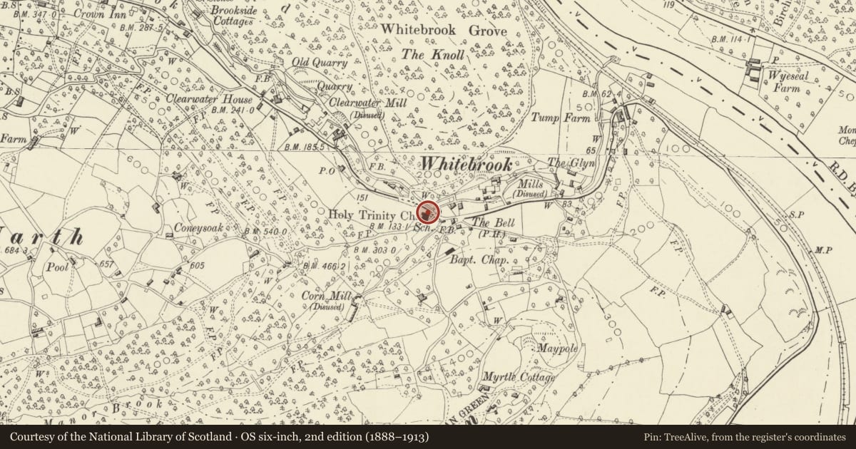
Slide toward Today to fade the historical sheet and see the modern map underneath.
David Rumsey Map Collection, Stanford LibrariesDavid Rumsey Map Collection, Stanford LibrariesDavid Rumsey Map Collection, Stanford LibrariesDavid Rumsey Map Collection, Stanford LibrariesDavid Rumsey Map Collection, Stanford Libraries
5 historical maps cover this location, the earliest the 1636 map "Cornubia : Devonia, Somersetus, Dorcestria, Wiltonia, Glocestria ..." (David Rumsey Map Collection, Stanford Libraries).
Historical maps covering this location
- 1636 · Cornubia : Devonia, Somersetus, Dorcestria, Wiltonia, Glocestria ... (David Rumsey Map Collection, Stanford Libraries)
- 1637 · The fourth table of England. Cornub. Devonia, Somerset etc. (David Rumsey Map Collection, Stanford Libraries)
- 1830 · V.3:11-15:XV.Britisches Reich. A. Kon: England. a. England ab sich: Shire:15-17, 33 (David Rumsey Map Collection, Stanford Libraries)
- 1895 · Sheet 11. Ordnance Survey of England and Wales. (David Rumsey Map Collection, Stanford Libraries)
- 1896 · 233 Monmouth (Hills) (David Rumsey Map Collection, Stanford Libraries)
Cadw's description
Location
On the south side of the road towards the eastern end of Whitebrook valley.
History
Small church of c1840 in the pre-ecclesiological lancet style with major alterations and the addition of a schoolroom on the south side, possibly in 1892. The conveyance of the land that the church is built on is dated 1838.
Exterior
The church is built of coursed squared red sandstone rubble with a Welsh slate roof, the schoolroom is rendered and painted. Single cell church with a west porch, probably added, and a schoolroom lean-to against the whole of the south wall. Gabled west end with two single light windows and a central gabled porch with a 4-centred head and small pointed windows in the return walls, original plank double doors. The main roof gable has a square bell-cote with an opening to each face, projecting eaves. The north wall has butresses with off-sets and two windows with Y-tracery. The east end has two windows as the west end. The schoolroom has a large 6 over 6 pane double sash at the east end and a small window and a 4-centred arch door at the west end, the south wall is blind.
Interior
The church appears to have been refitted, perhaps in 1892, with a large opening screen into the schoolroom, and an elaborately carved chancel screen known to have been done in 1892 by the Vicar, Joshua Stansfield, who also decorated the church at that time. The windows are 1840s coloured glass in diamond quarries. The roof is extremely elaborate in six bays with kingposts and other vertical struts all along the ties, boarded above.
Reason for designation
Included as an unusual example of a c1840 mission church in a newly populated industrial area with some interesting alterations of the1890s.
Nearby in the register
- Telephone Call-box (01600 860389)Communicationsunder 1 mi
- The BellDomesticunder 1 mi
- Cider Mill at Fern BankInstitutionalunder 1 mi
- Wye Valley MillhouseDomesticunder 1 mi
Other entries of the same register within about three miles of this one, by straight line.