Cof Cymru: National Historic Assets of Wales · Wales
Osbaston House
Monmouth, Monmouthshire, Wales
A Grade II listed building in Osbaston, Monmouth, Monmouthshire, designated on 15 August 1974.
The record
- Designation
- Listed building, Grade II
- Broad class
- Domestic
- Date of designation
- 15 August 1974
- Locality
- Osbaston
- Town
- Monmouth
- Community
- Monmouth
- Unitary authority
- Monmouthshire
- Country
- Wales
- Coordinates
- 51.82259, -2.72534
- Cadw reference
- 2370
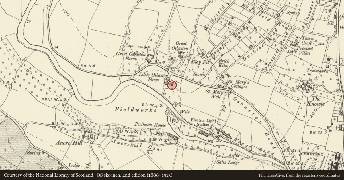
Slide toward Today to fade the historical sheet and see the modern map underneath.
David Rumsey Map Collection, Stanford LibrariesDavid Rumsey Map Collection, Stanford LibrariesDavid Rumsey Map Collection, Stanford LibrariesDavid Rumsey Map Collection, Stanford LibrariesDavid Rumsey Map Collection, Stanford Libraries
5 historical maps cover this location, the earliest the 1636 map "Cornubia : Devonia, Somersetus, Dorcestria, Wiltonia, Glocestria ..." (David Rumsey Map Collection, Stanford Libraries).
Historical maps covering this location
- 1636 · Cornubia : Devonia, Somersetus, Dorcestria, Wiltonia, Glocestria ... (David Rumsey Map Collection, Stanford Libraries)
- 1830 · V.3:11-15:XV.Britisches Reich. A. Kon: England. a. England ab sich: Shire:15-17, 33 (David Rumsey Map Collection, Stanford Libraries)
- 1895 · Sheet 11. Ordnance Survey of England and Wales. (David Rumsey Map Collection, Stanford Libraries)
- 1896 · 233 Monmouth (Hills) (David Rumsey Map Collection, Stanford Libraries)
- 1901 · Sheet 14. (David Rumsey Map Collection, Stanford Libraries)
Cadw's description
Location
About 1000m north of Monmouth Castle on the east bank of the river Monnow.
History
Early to mid C19 and externally little altered since apart from the addition of a wing and a porch in the late C20. The wing is not shown on the Tithe Map of 1843 and the house was then known as Little Osbaston.
Exterior
Completely stucco faced and painted with Welsh slate roofs. Double depth central entrance plan. Two storeys, three windows. Late C20 central glazed porch with plain doorway; 6 over 6 pane sashes on the ground floor and 3 over 6 pane sashes above. Hipped roof with two painted ridge stacks. Single bay wing added to right, one-and-a-half storeys with a 6 over 6 sash below and modern small paned casement in the roof above, another in right return. To the left a single storey wing with two 3-light windows and a door, clock turret on ridge, joins to the two storey coach house with casement windows and hipped roof.
Garden front of main block has the centre bay stepped forward under a barge-boarded gable. Central ground floor window has 6 over 9 panes to act as a doorway to the garden, tented canopy over; other windows are sashes as before.
Interior
Interior not seen at resurvey.
Reason for designation
Included for its special architectural interest as an early C19 villa which has retained its character.
Nearby in the register
- Osbaston WeirIndustrialunder 1 mi
- Salts LodgeDomesticunder 1 mi
- Vauxhall FarmhouseNo class recordedunder 1 mi
- Monnow MillIndustrialunder 1 mi
Other entries of the same register within about three miles of this one, by straight line.