Cof Cymru: National Historic Assets of Wales · Wales
Horeb Presbyterian Church including attached hall to right
Pentyrch, Cardiff, Wales
A Grade II listed building in Pen-y-garn, Pentyrch, Cardiff, designated on 31 January 2000.
The record
- Designation
- Listed building, Grade II
- Broad class
- Religious, Ritual and Funerary
- Date of designation
- 31 January 2000
- Locality
- Pen-y-garn
- Community
- Pentyrch
- Unitary authority
- Cardiff
- Country
- Wales
- Coordinates
- 51.53086, -3.29754
- Cadw reference
- 22821
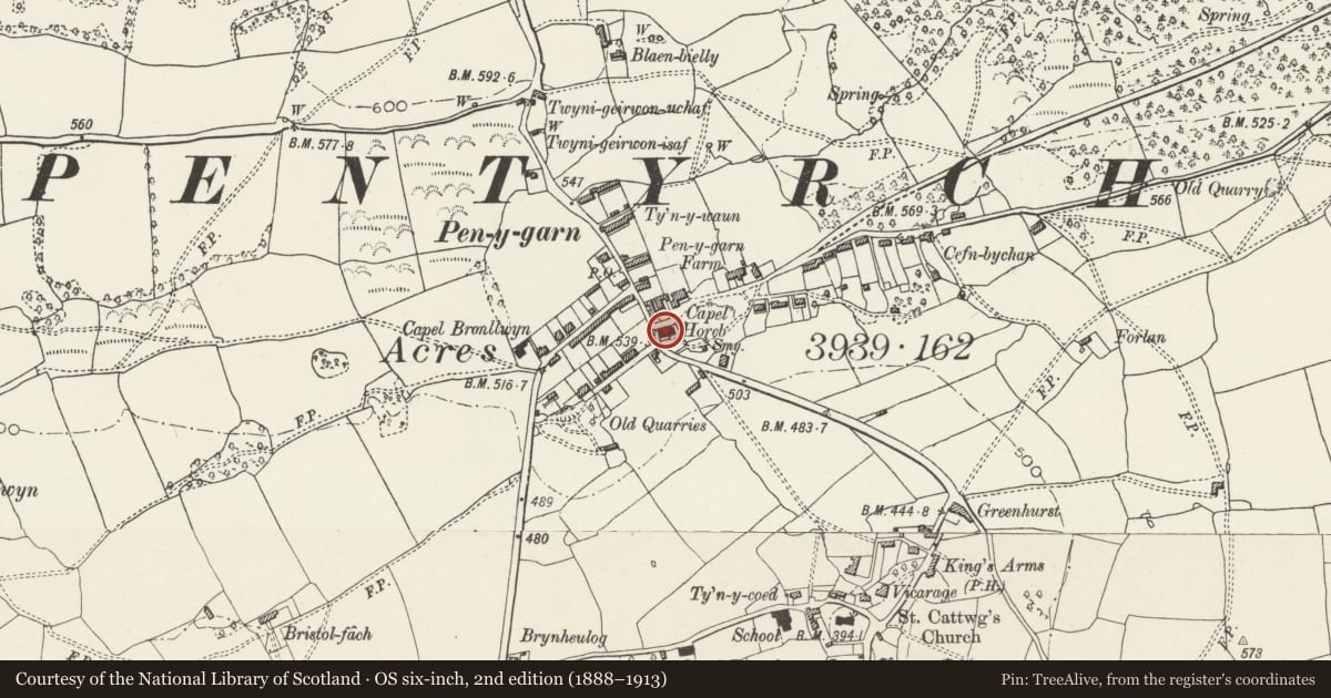
Slide toward Today to fade the historical sheet and see the modern map underneath.
David Rumsey Map Collection, Stanford LibrariesDavid Rumsey Map Collection, Stanford LibrariesDavid Rumsey Map Collection, Stanford LibrariesDavid Rumsey Map Collection, Stanford LibrariesDavid Rumsey Map Collection, Stanford Libraries
5 historical maps cover this location, the earliest the 1636 map "Cornubia : Devonia, Somersetus, Dorcestria, Wiltonia, Glocestria ..." (David Rumsey Map Collection, Stanford Libraries).
Historical maps covering this location
- 1636 · Cornubia : Devonia, Somersetus, Dorcestria, Wiltonia, Glocestria ... (David Rumsey Map Collection, Stanford Libraries)
- 1637 · The fourth table of England. Cornub. Devonia, Somerset etc. (David Rumsey Map Collection, Stanford Libraries)
- 1865 · England and Wales. England No. 6. (David Rumsey Map Collection, Stanford Libraries)
- 1895 · Sheet 11. Ordnance Survey of England and Wales. (David Rumsey Map Collection, Stanford Libraries)
- 1898 · 263 Cardiff (Hills) (David Rumsey Map Collection, Stanford Libraries)
Cadw's description
Location
In the hamlet of Pen-y-garn NW of Pentyrch, on the hillside at the junction with Heol Goch, the road to Gwaeold-y-garth, and set in a walled graveyard.
History
Calvinistic Methodist chapel built 1838, rebuilt 1862.
Exterior
Plain chapel with unusual 4-window gable-end facade and lower hall wing. Cement rendered with Welsh slate roof with overhanging eaves. Main S facing frontage has 4 identical round-headed gallery windows with multipane and margin glazing incorporating some coloured glass, a blind roundel in the apex and a small date plaque at centre, and to ground floor 2 doorways with boarded doors and margin glazed fanlights. Stepped back the 3-bay hall range has 9/4 pane sashes and a cambered headed doorway. Rear chapel elevation has a simple moulded cornice and 4 rectangular margin-glazed windows to each floor.
Interior
3- sided gallery with panelled front, supported on 5 cast-iron columns with deep panelled coving, the panelled pews with moulded ends long and curved round the angles. Woodwork is all in light toned grained paintwork. On the ground floor the panelled pews have doors; those to sides face inwards, not angled, with panelled dado. Panelled set fawr, panelled pulpit with simple bench with further panelling to rear rising to a scrolled pediment. Small vestibules with doorcases with part-glazed doors with margin glazing provide access to ground floor at preacher's end and gallery. Part scored render.
Reason for designation
Listed as a mid C19 chapel retaining much of its original appearance and in particular a finely panelled and pewed interior.
Nearby in the register
- Former Penuel ChapelReligious, Ritual and Funeraryunder 1 mi
- Church of St CatwgReligious, Ritual and Funeraryunder 1 mi
- Lychgate at church of St CatwgReligious, Ritual and Funeraryunder 1 mi
- The King's Arms Public HouseRecreationalunder 1 mi
Other entries of the same register within about three miles of this one, by straight line.