Cof Cymru: National Historic Assets of Wales · Wales
Ty Celyn, former kennel/stable building to Ty-Brith and attached wall
Usk, Monmouthshire, Wales
A Grade II listed building in Usk, Monmouthshire, designated on 1 April 1974.
The record
- Designation
- Listed building, Grade II
- Broad class
- Domestic
- Date of designation
- 1 April 1974
- Locality
- Usk
- Town
- Usk
- Community
- Usk
- Unitary authority
- Monmouthshire
- Country
- Wales
- Coordinates
- 51.70330, -2.90141
- Cadw reference
- 2199
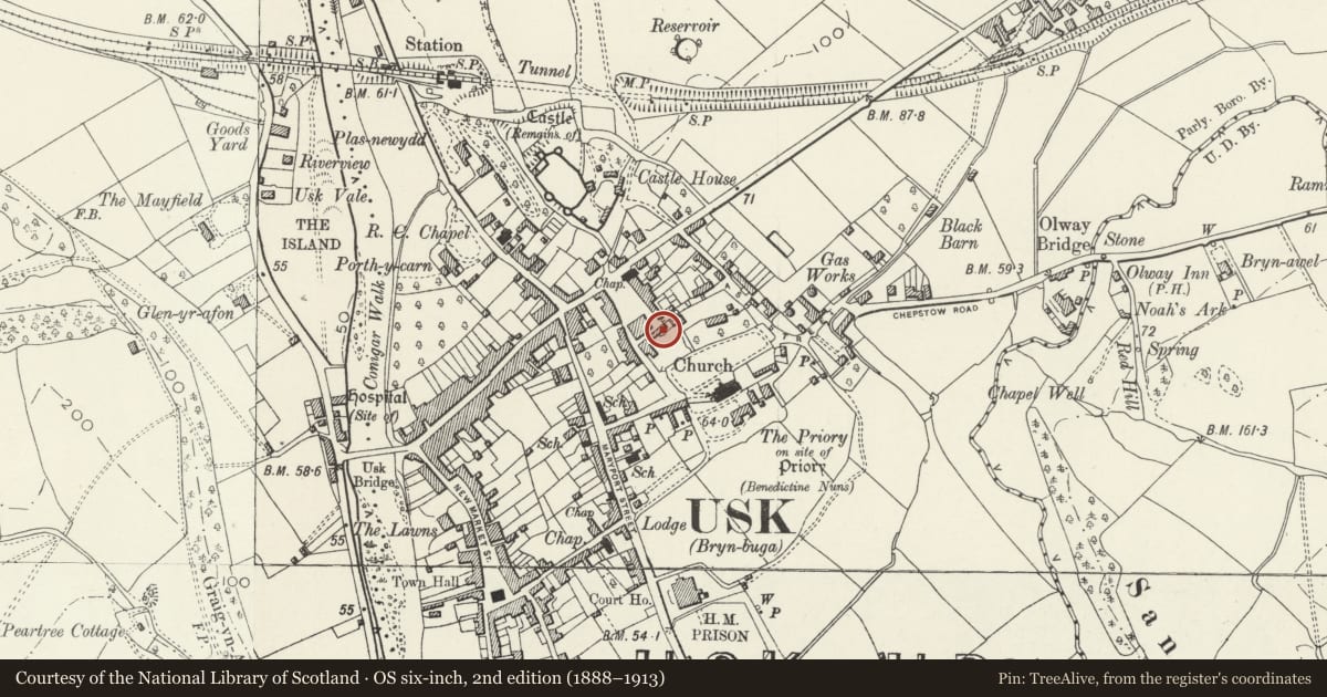
Slide toward Today to fade the historical sheet and see the modern map underneath.
David Rumsey Map Collection, Stanford LibrariesDavid Rumsey Map Collection, Stanford LibrariesDavid Rumsey Map Collection, Stanford LibrariesDavid Rumsey Map Collection, Stanford LibrariesDavid Rumsey Map Collection, Stanford Libraries
5 historical maps cover this location, the earliest the 1636 map "Cornubia : Devonia, Somersetus, Dorcestria, Wiltonia, Glocestria ..." (David Rumsey Map Collection, Stanford Libraries).
Historical maps covering this location
- 1636 · Cornubia : Devonia, Somersetus, Dorcestria, Wiltonia, Glocestria ... (David Rumsey Map Collection, Stanford Libraries)
- 1637 · The fourth table of England. Cornub. Devonia, Somerset etc. (David Rumsey Map Collection, Stanford Libraries)
- 1830 · V.3:11-15:XV.Britisches Reich. A. Kon: England. a. England ab sich: Shire:15-17, 33 (David Rumsey Map Collection, Stanford Libraries)
- 1895 · Sheet 11. Ordnance Survey of England and Wales. (David Rumsey Map Collection, Stanford Libraries)
- 1913 · Sheet 102. Newport. (David Rumsey Map Collection, Stanford Libraries)
Cadw's description
Location
Together with the side elevation of Ty Brith forms the S range of Twyn Square.
History
Early C19.
Exterior
Former stable/kennel range, now dwelling. Most prominent town elevation is to Twyn Square, a long range of rubble stone with hipped slate roof and brick lateral stacks. Two storeys. Three-window range of widely spaced small round-arched 6-pane sashes with brick dressings to first floor; segmental-arched with 9 panes to ground floor; sympathetically replaced glazing. Blocked segmental-arched doorway at right. Attached a stretch of stone wall with shallow coping, swept down from below eaves-level, matching that to right. The inner-facing elevation is quite different, stucco-rendered and painted with triple gables with decorative pierced barge-boards. Small apex lights with stone surrounds and hoodmoulds, first floor cross-framed windows with lattice glazing under square hoodmoulds, similar ground floor windows, a 4-window range; three lights to sides, all with yellow brick hoodmoulds. Central doorway with boarded door with decorative hinges and divided overlight; second boarded door to right.
Reason for designation
Listed as an integral part of the Ty Brith complex. Group value with this and other listed buildings in Twyn Square.
Nearby in the register
- Ty Brith, and attached courtyard wallDomesticunder 1 mi
- The Old BakeryDomesticunder 1 mi
- Former coach-house to Ty Brith (5 Denbury Mews) and attached wallTransportunder 1 mi
- Ty Brith CottageDomesticunder 1 mi
Other entries of the same register within about three miles of this one, by straight line.