Cof Cymru: National Historic Assets of Wales · Wales
White Hart Bridge (Canal Bridge No.143) including attached retaining wall
Talybont-on-Usk, Powys, Wales
A Grade II listed building in Talybont, Talybont-on-Usk, Powys, designated on 17 December 1998.
The record
- Designation
- Listed building, Grade II
- Broad class
- Transport
- Date of designation
- 17 December 1998
- Locality
- Talybont
- Community
- Talybont-on-Usk
- Unitary authority
- Powys
- Country
- Wales
- Coordinates
- 51.89418, -3.28792
- Cadw reference
- 21116
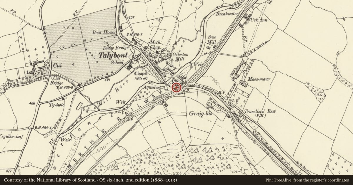
Slide toward Today to fade the historical sheet and see the modern map underneath.
David Rumsey Map Collection, Stanford LibrariesDavid Rumsey Map Collection, Stanford LibrariesDavid Rumsey Map Collection, Stanford LibrariesDavid Rumsey Map Collection, Stanford LibrariesDavid Rumsey Map Collection, Stanford Libraries
5 historical maps cover this location, the earliest the 1608 map "(13) Cambriae Typus." (David Rumsey Map Collection, Stanford Libraries).
Historical maps covering this location
- 1608 · (13) Cambriae Typus. (David Rumsey Map Collection, Stanford Libraries)
- 1636 · Cornubia : Devonia, Somersetus, Dorcestria, Wiltonia, Glocestria ... (David Rumsey Map Collection, Stanford Libraries)
- 1856 · 42. Brecon. (David Rumsey Map Collection, Stanford Libraries)
- 1896 · 214 Talgarth (Hills) (David Rumsey Map Collection, Stanford Libraries)
- 1901 · Sheet 14. (David Rumsey Map Collection, Stanford Libraries)
Cadw's description
Location
In the centre of Talybont village, to the rear of the White Hart Public House.
History
The Brecknock and Abergavenny Canal was promoted in 1792 to connect the upper Usk valley with the Monmouthshire Canal at Pontymoile and from there to the sea at Newport. First section, between Gilwern and Talybont, was cut between 1797 and 1799, with upper section between Talybont and Brecon opened in 1800, both sections engineered by Thomas Dadford. Lower section between Gilwern and Pontymoile completed 1812 and engineered by William Crosley. Linked to tramroads, the canal was an important artery for trade in iron, lime and coal. In 1865 the Brecknock and Abergavenny and the Monmouthshire Canals merged to become the Monmouthshire and Brecon Canal, which was later incorporated into the Great Western Railway. Many bridges had large cast iron weight restriction notices on poles erected at each end. Last toll was taken in 1933. Restoration of canal began 1964.
Exterior
Hump-back bridge of rubble sandstone. Segmental arch has thin voussoirs and low parapet with flat coping. The abutments curve outwards on both sides and the parapet has square end piers. On the E side is a cast iron plaque with the bridge number cast in relief in keystone position. The towpath passes under bridge on N side and has a stone kerb; on S side is a stringcourse roughly at water level.
This bridge rises to W and is reinforced with metal ribs under the vault. It defines the S border of the Talybont Basin and adjoins a long retaining wall which borders the Basin to S with weir below; to W is the aqueduct over the Caerfanell River. No string course visible on W side and only one pier NW. Concrete surface.
Reason for designation
One of a group of original Brecknock and Abergavenny Canal bridges.
Group value with other listed structures in Talybont village
Nearby in the register
- White Hart InnCommercialunder 1 mi
- Pair of railway bridges over road and canal at TalybontTransportunder 1 mi
- Talybont Aqueduct (Monmouthshire and Brecon Canal)Transportunder 1 mi
- Weighbridge CottageTransportunder 1 mi
Other entries of the same register within about three miles of this one, by straight line.