Cof Cymru: National Historic Assets of Wales · Wales
Meifod
Rossett, Wrexham, Wales
A Grade II listed building in Burton, Rossett, Wrexham, designated on 18 October 1996.
The record
- Designation
- Listed building, Grade II
- Broad class
- Domestic
- Date of designation
- 18 October 1996
- Locality
- Burton
- Community
- Rossett
- Unitary authority
- Wrexham
- Country
- Wales
- Coordinates
- 53.10704, -2.96112
- Cadw reference
- 17459
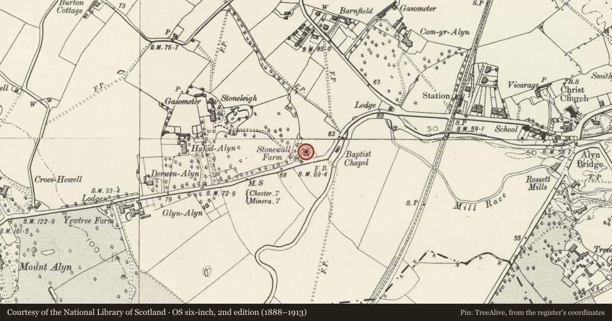
Slide toward Today to fade the historical sheet and see the modern map underneath.
David Rumsey Map Collection, Stanford LibrariesDavid Rumsey Map Collection, Stanford LibrariesDavid Rumsey Map Collection, Stanford LibrariesDavid Rumsey Map Collection, Stanford LibrariesDavid Rumsey Map Collection, Stanford Libraries
5 historical maps cover this location, the earliest the 1608 map "(13) Cambriae Typus." (David Rumsey Map Collection, Stanford Libraries).
Historical maps covering this location
- 1608 · (13) Cambriae Typus. (David Rumsey Map Collection, Stanford Libraries)
- 1637 · Particular description of Wales. Cambria seu Wallia (David Rumsey Map Collection, Stanford Libraries)
- 1883 · Watershed map England, Wales 3. (David Rumsey Map Collection, Stanford Libraries)
- 1898 · 108 Flint (Hills) (David Rumsey Map Collection, Stanford Libraries)
- 1901 · Sheet 9 and 10. (David Rumsey Map Collection, Stanford Libraries)
Cadw's description
Location
Situated to the north side of Llay Road and to the west of the River Alyn. Adjacent to the former Lodge to Stoneleigh House.
History
Date stone of 1818 identifies Meifod as one of the estate houses constructed during the stewardship of Trevalyn held by John Boydell. Hubbard claims that upper storey is later. No discernible evidence in the fabric to suggest such a claim and 1818 is entirely consistent with the building of such houses throughout Rossett, Gresford, and Marford, as Hubbard argues elsewhere.
Exterior
Two-storey, painted, pebble-dashed brick construction. Pitched slate roof. Cottage Orne style of the Picturesque movement. Symmetrically composed front elevation under central dentilated broken triangular pediment. Pediment encloses date stone of 1818. Brick dentilated cornice tops highly distinctive undulating, or convex, treatment of the facade. Purlins exposed to pediment and gable ends to east and west. Ogee-arched Gothick windows to ground floor with later uPVC windows inserted; similar square-headed windows to 1st floor. To east and west returns blind circular window with quatrefoil. Blocked ogee doorway to east, new chimney stacks, and rear extension with catslide roof suggest alteration in late C19/early C20.
Interior
Internal inspection not possible at time of 1995 re-survey.
Reason for designation
Listed, notwithstanding replacement windows, as an example, dated 1818, of the distinctive picturesque estate houses constructed during the Stewardship of Trevalyn held by John Boydell.
Nearby in the register
- The Stone HouseDomesticunder 1 mi
- 1 Yew Tree CottagesDomesticunder 1 mi
- 2 Yew Tree CottagesDomesticunder 1 mi
- Outbuilding range immediately E of Yew Tree FarmAgriculture and Subsistenceunder 1 mi
Other entries of the same register within about three miles of this one, by straight line.