Cof Cymru: National Historic Assets of Wales · Wales
Bonvilston Cottage
St. Nicholas and Bonvilston, Vale of Glamorgan, Wales
A Grade II listed building in Bonvilston, St. Nicholas and Bonvilston, Vale of Glamorgan, designated on 31 July 1995.
The record
- Designation
- Listed building, Grade II
- Broad class
- Domestic
- Date of designation
- 31 July 1995
- Locality
- Bonvilston
- Community
- St. Nicholas and Bonvilston
- Unitary authority
- Vale of Glamorgan
- Country
- Wales
- Coordinates
- 51.45734, -3.34861
- Cadw reference
- 16319
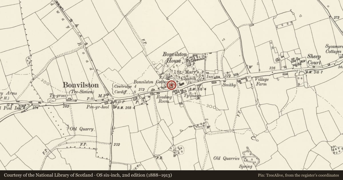
Slide toward Today to fade the historical sheet and see the modern map underneath.
David Rumsey Map Collection, Stanford LibrariesDavid Rumsey Map Collection, Stanford LibrariesDavid Rumsey Map Collection, Stanford LibrariesDavid Rumsey Map Collection, Stanford LibrariesDavid Rumsey Map Collection, Stanford Libraries
5 historical maps cover this location, the earliest the 1636 map "Cornubia : Devonia, Somersetus, Dorcestria, Wiltonia, Glocestria ..." (David Rumsey Map Collection, Stanford Libraries).
Historical maps covering this location
- 1636 · Cornubia : Devonia, Somersetus, Dorcestria, Wiltonia, Glocestria ... (David Rumsey Map Collection, Stanford Libraries)
- 1637 · The fourth table of England. Cornub. Devonia, Somerset etc. (David Rumsey Map Collection, Stanford Libraries)
- 1865 · England and Wales. England No. 6. (David Rumsey Map Collection, Stanford Libraries)
- 1895 · Sheet 11. Ordnance Survey of England and Wales. (David Rumsey Map Collection, Stanford Libraries)
- 1897 · 262 Pontypridd (Hills) (David Rumsey Map Collection, Stanford Libraries)
Cadw's description
Location
Located on the N side of the A48, to the W of Bonvilston Parish Church of St. Mary, set back of the road behind a high limestone rubble wall.
Exterior
Two-storey Regency house, rendered elevations and slated hipped roof with two gable stacks and three axial. Of oblong plan with central ridge and hipped wing running N/S at the W end. Bracketed eaves. Three bays wide, with three twelve pane sashes, with horns, to the front first floor. Three sets of French doors to the ground floor set behind colonnade of six Ionic columns with slated lean-to roof. The colonnade returns around the E elevation leading to the front entrance which is set back from the facade of the main house. The front door is four panelled with the lower two panels flush, set within wide reeded timber architrave. The rear elevation has three twelve pane sashes to first floor with sashes to ground floor and Roman Doric colonnade (possibly later) to the rear. Slate-hung downhill gable end. Projecting W wing has steeply pitched slated lean-to roof to ground floor, with French doors beneath. Substantially extended to the E and NE with late C19 and C20 accretions including self-contained annex to the E.
Interior
Not accessible at time of inspection (May 1995).
Reason for designation
Listed grade II as a good example of a large late Georgian house and for group value with the Parish Church and neighbouring listed items.
Nearby in the register
- Parish Church of St Mary the VirginReligious, Ritual and Funeraryunder 1 mi
- Churchuard Cross at Parish Church of St MaryReligious, Ritual and Funeraryunder 1 mi
- Ty Mawr (Great House)Domesticunder 1 mi
- Milestone opposite the Old Village Shop, BonvilstonNo class recordedunder 1 mi
Other entries of the same register within about three miles of this one, by straight line.