Cof Cymru: National Historic Assets of Wales · Wales
Former Town Hall
Hawarden, Flintshire, Wales
A Grade II listed building in Hawarden, Flintshire, designated on 16 November 1994.
The record
- Designation
- Listed building, Grade II
- Broad class
- Civil
- Date of designation
- 16 November 1994
- Community
- Hawarden
- Unitary authority
- Flintshire
- Country
- Wales
- Coordinates
- 53.18438, -3.02396
- Cadw reference
- 15065
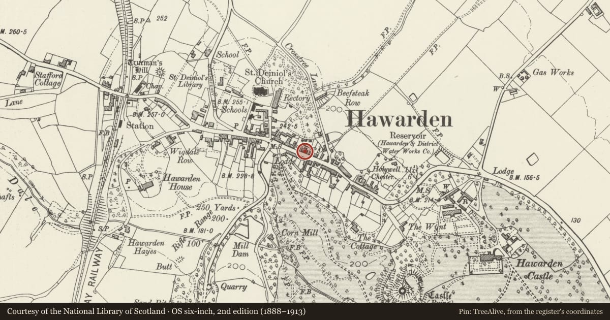
Slide toward Today to fade the historical sheet and see the modern map underneath.
David Rumsey Map Collection, Stanford LibrariesDavid Rumsey Map Collection, Stanford LibrariesDavid Rumsey Map Collection, Stanford LibrariesDavid Rumsey Map Collection, Stanford LibrariesLlyfrgell Genedlaethol Cymru – The National Library of Wales
5 historical maps cover this location, the earliest the 1795 map "To Sir Watkin Williams-Wynn Bart ... the map of the six counties of North Wales is most humbly inscribed by his obedient humble servant" (Llyfrgell Genedlaethol Cymru – The National Library of Wales).
Historical maps covering this location
- 1795 · To Sir Watkin Williams-Wynn Bart ... the map of the six counties of North Wales is most… (Llyfrgell Genedlaethol Cymru – The National Library of Wales)
- 1883 · Watershed map England, Wales 3. (David Rumsey Map Collection, Stanford Libraries)
- 1898 · 108 Flint (Hills) (David Rumsey Map Collection, Stanford Libraries)
- 1898 · 108 Flint (Outline) (David Rumsey Map Collection, Stanford Libraries)
- 1901 · Sheet 9 and 10. (David Rumsey Map Collection, Stanford Libraries)
Cadw's description
Location
On the street line.
Exterior
2 associated and adjoining ranges built in 1886 in playful Tudor style as a police station (to the R) and town hall (L range).
The Police Station: A 2-storey symmetrical, twin gabled building with narrow recessed central entrance bay. Of brick with painted stone detailing. Tiled roof with plain oversailing eaves and bargeboards. 3 simply moulded stacks. Simple, 3-light plain glazed windows to first floor of each flanking bay, with moulded mullions. Similar 6-light mullioned and transomed windows to ground floor. Continuous moulded brick dripcourses and 2 similar stringcourses. Plain moulded plinth. Central bay with narrow entrance. Depressed arched head with fluted keystone and moulded surround. Contemporary door with simple scrolled ironwork. First floor single-light window with moulded ogee head. Decorative stone relief plaques to both gables, that to the L bearing the date 1886. External clock on decorative iron scrolled bracket. An inserted stone plaque in the L bay records its erection in 1911.
Alleyway to R with contemporary flat-arched opening and stepped brick-coped wall running N.
Adjoining to the W the contemporary Town Hall.
Town Hall: Single-storey with large Dutch gable to the W. Of 2 bays, the R one advanced and both with catslide roofs. Central dormer with timber-framed gable and plain eaves, containing a 3-light leaded window. Each bay with a 3-light mullioned window to the L of a door, that of the L bay now blocked and rebuilt as a window. Contemporary door to R with ironwork and mouldings as before.
Moulded plinth, mullions and window reveals. Renaissance grotesque decoration in the W gable pediment. Lead coping to gable. 10-light mullioned and transomed leaded window beneath.
Modern brick extensions to rear.
Reason for designation
Included for group value with other items in Glynne Way.
Nearby in the register
- Former Police StationCivilunder 1 mi
- 26 Glynne WayDomesticunder 1 mi
- 28 Glynne WayDomesticunder 1 mi
- 24 Glynne WayDomesticunder 1 mi
Other entries of the same register within about three miles of this one, by straight line.