Cof Cymru: National Historic Assets of Wales · Wales
26 Glynne Way
Hawarden, Flintshire, Wales
A Grade II listed building in Hawarden, Flintshire, designated on 16 November 1994.
The record
- Designation
- Listed building, Grade II
- Broad class
- Domestic
- Date of designation
- 16 November 1994
- Community
- Hawarden
- Unitary authority
- Flintshire
- Country
- Wales
- Coordinates
- 53.18424, -3.02409
- Cadw reference
- 15042
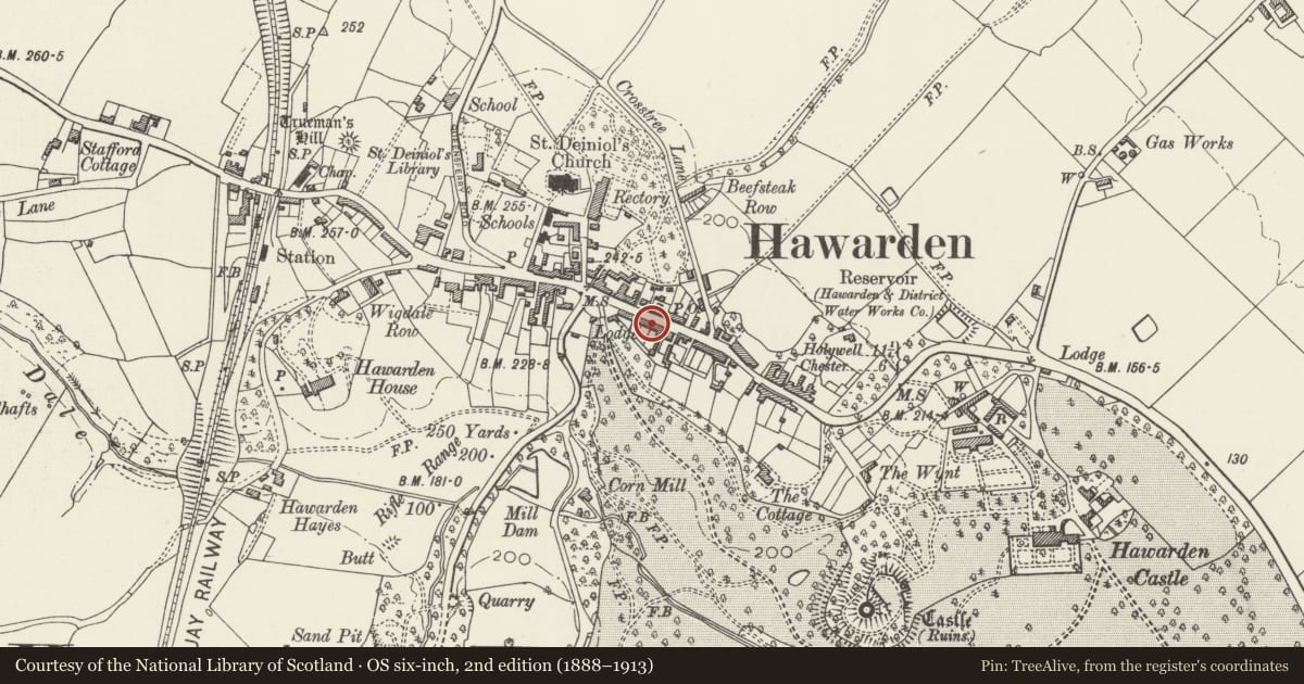
Slide toward Today to fade the historical sheet and see the modern map underneath.
David Rumsey Map Collection, Stanford LibrariesDavid Rumsey Map Collection, Stanford LibrariesDavid Rumsey Map Collection, Stanford LibrariesDavid Rumsey Map Collection, Stanford LibrariesLlyfrgell Genedlaethol Cymru – The National Library of Wales
5 historical maps cover this location, the earliest the 1795 map "To Sir Watkin Williams-Wynn Bart ... the map of the six counties of North Wales is most humbly inscribed by his obedient humble servant" (Llyfrgell Genedlaethol Cymru – The National Library of Wales).
Historical maps covering this location
- 1795 · To Sir Watkin Williams-Wynn Bart ... the map of the six counties of North Wales is most… (Llyfrgell Genedlaethol Cymru – The National Library of Wales)
- 1883 · Watershed map England, Wales 3. (David Rumsey Map Collection, Stanford Libraries)
- 1898 · 108 Flint (Hills) (David Rumsey Map Collection, Stanford Libraries)
- 1898 · 108 Flint (Outline) (David Rumsey Map Collection, Stanford Libraries)
- 1901 · Sheet 9 and 10. (David Rumsey Map Collection, Stanford Libraries)
Cadw's description
Location
Located immediately to the E of the castle entrance, opposite the Glynne Arms.
Exterior
An early C19, 2-storey terrace range of 14 cottages, each of one bay and with paired entrances. The main front of flush, uncoursed sandstone with tooled sandstone dressings. Continuous shallow-pitched slate roof with coped and shaped gable to the W. Plain eaves cornice. Contemporary twin square chimney stacks serving Nos 4 and 6, with moulded caps, off-set on a square base. All other stacks of dark factory brick and of octagonal design. Each cottage retains its contemporary door, of 3 vertical panels approached by 2 steps (mostly replaced). Plain chamfered
doorcases. No. 30 has a plain rectangular fanlight. No. 4 has a wide, flat-arched cellar light. Otherwise each unit has single aligned ground and first floor windows of 2 lights and 2 panes. Upper windows are slightly narrower than lower ones. All with plain chamfered lintels, cills and reveals; all cills now painted. No. 30 has a later 3-light, 6-pane ground floor window, with wooden, grained lintel (this relates to a late C19 remodelling as a saddlers' shop). W gable with stone mullioned windows to ground and first floor, of 3 and 2 lights respectively, each with moulded and returned label.
Except Nos 4-10, rear elevations are of red brick with dentilated eaves, and each cottage has a later rear extension. Nos 4 - 10 are of sandstone throughout, and a break can be detected between Nos 10 and 12. This suggests that Nos 4-10 were built first and that the terrace was subsequently continued to the same design. Presumably, however, the time gap between the original 4-unit construction and the additions to the E cannot of been long.
Reason for designation
Good group value in a prominent position within the village.
Nearby in the register
- 24 Glynne WayDomesticunder 1 mi
- 28 Glynne WayDomesticunder 1 mi
- 22 Glynne WayDomesticunder 1 mi
- 30 Glynne WayDomesticunder 1 mi
Other entries of the same register within about three miles of this one, by straight line.