Cof Cymru: National Historic Assets of Wales · Wales
Train Shed at Holyhead Station
Holyhead, Isle of Anglesey, Wales
A Grade II listed building in Holyhead, Isle of Anglesey, designated on 25 July 1994.
The record
- Designation
- Listed building, Grade II
- Broad class
- Transport
- Date of designation
- 25 July 1994
- Community
- Holyhead
- Unitary authority
- Isle of Anglesey
- Country
- Wales
- Coordinates
- 53.30820, -4.63033
- Cadw reference
- 14739
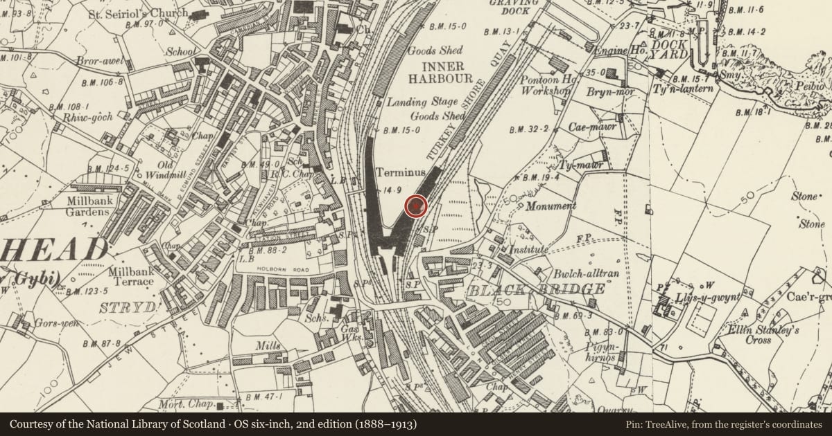
Slide toward Today to fade the historical sheet and see the modern map underneath.
David Rumsey Map Collection, Stanford LibrariesDavid Rumsey Map Collection, Stanford LibrariesDavid Rumsey Map Collection, Stanford LibrariesDavid Rumsey Map Collection, Stanford LibrariesDavid Rumsey Map Collection, Stanford Libraries
5 historical maps cover this location, the earliest the 1799 map "Ireland." (David Rumsey Map Collection, Stanford Libraries).
Historical maps covering this location
- 1799 · Ireland. (David Rumsey Map Collection, Stanford Libraries)
- 1883 · Watershed map England, Wales 3. (David Rumsey Map Collection, Stanford Libraries)
- 1899 · 93 Holyhead (Hills) (David Rumsey Map Collection, Stanford Libraries)
- 1901 · Sheet 9 and 10. (David Rumsey Map Collection, Stanford Libraries)
- 1919 · Sheet 41. Anglesey. (David Rumsey Map Collection, Stanford Libraries)
Cadw's description
Location
On E side of inner angle of Holyhead inner harbour.
History
Development of station and hotel by LNWR 1876 to 1880 consisted of hotel at apex of inner harbour flanked by arrival (E) and departure (W) platforms. Covered by sheds with Euston type roofs. Hotel closed 1950's demolished with W platform circa 1979, leaving this former arrivals platform. W part of site subsequently redeveloped.
Exterior
Long curving train shed (approximately 300m long) in red brick with stone cornice and dressings, string courses of moulded yellow brick; roof covered in modern opaque and translucent corrugated materials, long ridge lantern. E side of shed consist of series of elliptical arches grouped in 18 bays of three articulted by pilasters, each bay has broader centra; arch with narrower arch to each side; four of these groups are open for access, others open only in lunettes for ventilation (some alterations to arches at S end).
Narrower NE end of shed, 3 bay of 3 arches in same style, modern brick gable end
W side of shed originally open to quay. Roof supported on iron columns on octagonal plinths, but many of these now encased in mid C20 brick service buildings (buffets etc). Towards SW end 14 arches of wall of former hotel remain in situ supporting roof. Red brick with stone dressings on stone plinth. Four groups of 3 segmentally arched windows, white glazed bricks to jambs, buff ceramic patent stone to heads and keystones. Between first 2 window groups.large doorway in same style; smaller doorway to centre in same style. Openings blocked in modern red brick.
Euston tpye iron roof, W side supported on cast iron brackets with fretted leaf decorationspringing from columns and lattice girders (similar brackets supported lost canopt to Quayside ). E side of roof sits on wall and ahed. Rooftrusses consist of framework of wrought - Iron tie bars of round or T section, cental sedtio Central section which encompasses ridge ventilator has round-sectioned cross bars and tensioners and further cast- iron brackets with leaf pattern used as ridge pieces. Platforms modernised in concrete with concrete or tarmac surfaces.
Reason for designation
Included for hisoric importance as remaining part of the major rebuilding of Holyhead Station. Believed to be the longest station train shed in Wales.
Nearby in the register
- Clock Turret in Station ApproachGardens, Parks and Urban Spacesunder 1 mi
- Plas AlltranDomesticunder 1 mi
- 2 Turkey Shore RoadDomesticunder 1 mi
- 1 Turkey Shore RoadDomesticunder 1 mi
Other entries of the same register within about three miles of this one, by straight line.