Cof Cymru: National Historic Assets of Wales · Wales
Wellfield
Llanelli, Carmarthenshire, Wales
A Grade II listed building in Llanelli, Carmarthenshire, designated on 12 March 1992.
The record
- Designation
- Listed building, Grade II
- Broad class
- Domestic
- Date of designation
- 12 March 1992
- Community
- Llanelli
- Unitary authority
- Carmarthenshire
- Country
- Wales
- Coordinates
- 51.68609, -4.16725
- Cadw reference
- 11937
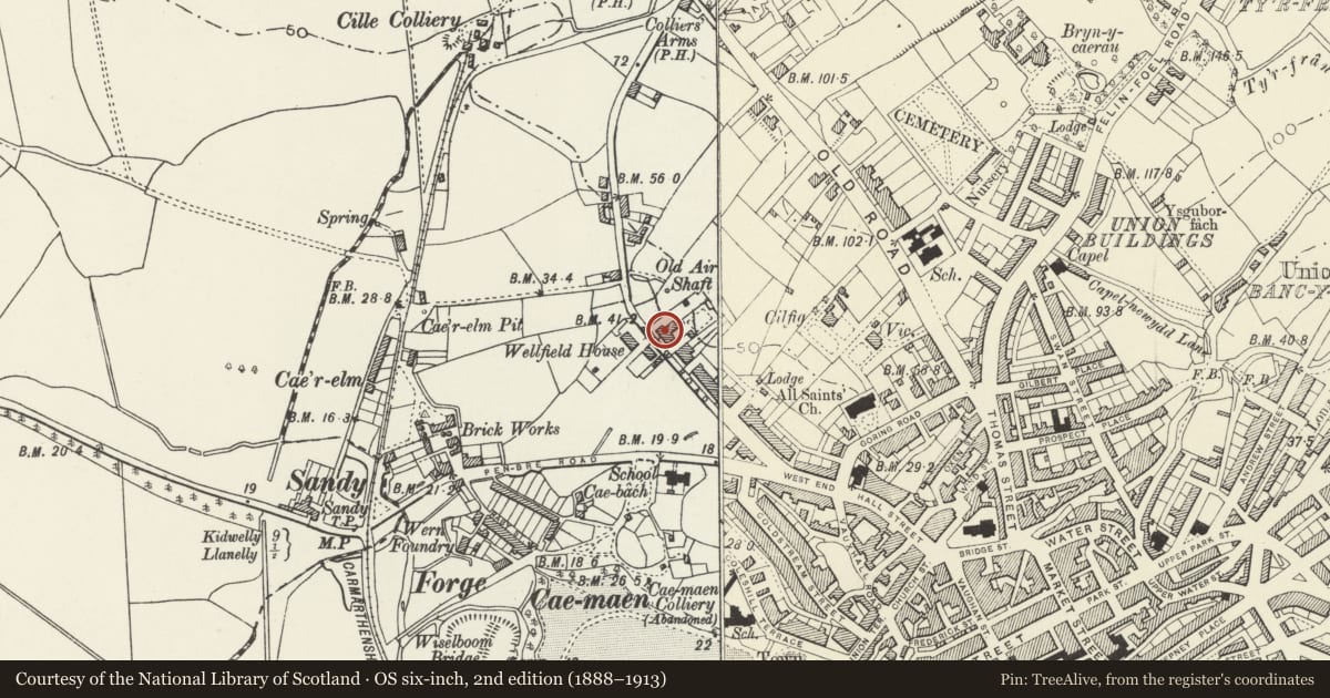
Slide toward Today to fade the historical sheet and see the modern map underneath.
David Rumsey Map Collection, Stanford LibrariesDavid Rumsey Map Collection, Stanford LibrariesNational Library of ScotlandDavid Rumsey Map Collection, Stanford LibrariesDavid Rumsey Map Collection, Stanford Libraries
5 historical maps cover this location, the earliest the 1636 map "Cornubia : Devonia, Somersetus, Dorcestria, Wiltonia, Glocestria ..." (David Rumsey Map Collection, Stanford Libraries).
Historical maps covering this location
- 1636 · Cornubia : Devonia, Somersetus, Dorcestria, Wiltonia, Glocestria ... (David Rumsey Map Collection, Stanford Libraries)
- 1637 · The fourth table of England. Cornub. Devonia, Somerset etc. (David Rumsey Map Collection, Stanford Libraries)
- 1891 · Sheet 10. Ordnance Survey of England and Wales. . (David Rumsey Map Collection, Stanford Libraries)
- 1920 · Sheet 100. Llanelly. (David Rumsey Map Collection, Stanford Libraries)
- 1963 · Map No. 4 - Local Government Commission for Wales : [Definitive maps showing proposed… (National Library of Scotland)
Cadw's description
Location
Situated just back from street-line some 100 m north west of junction with Harries Avenue.
Exterior
Circa 1830-40 semi-detached pair of villas, stucco with painted stone dressings and slate or imitation slate roofs behind parapets. A mirrored pair with 2-window centre and slightly advanced and bowed one-window sides. Modern extensions beyond. Centre has deep parapet with applied simple pediment, dentilled to right half (No 58) but not to left. Two first-floor sashes, original marginal glazing bars to No 60, plastic to No 58; broad sill band with upper part raised. Full-length ground floor windows, with original marginal glazing to No 60, plastic to No 58. Wings are slightly lower with broad curved projection, high parapet, dentilled cornice to No 58, plain raised course to Noá60, similar first floor sashes, plastic to No 58, sill-band carried across, and ground floor similar full-length window to No 60. No 58 has door with
circa 1900 segmental hood on brackets.
No 58 has 2 window range to right with first floor sill band but otherwise much modernised. Hipped concrete tile roof. No 60 has circa 1900 2-storey range to left with half-timbered gable to left bay.
Low rubble stone garden wall to No 60, rendered wall to No 58.
Reason for designation
Included (despite alterations) as distinctive early C19 semi-detached pair in Regency style, rare in Llanelli.
Nearby in the register
- RavenscourtDomesticunder 1 mi
- Craig HouseDomesticunder 1 mi
- 47 including Gates and Railings to ForecourtDomesticunder 1 mi
- 45 including Gates and Railings to ForecourtDomesticunder 1 mi
Other entries of the same register within about three miles of this one, by straight line.