Sites and Monuments Record · Ireland
Souterrain
Drumlohan, County Waterford, Ireland
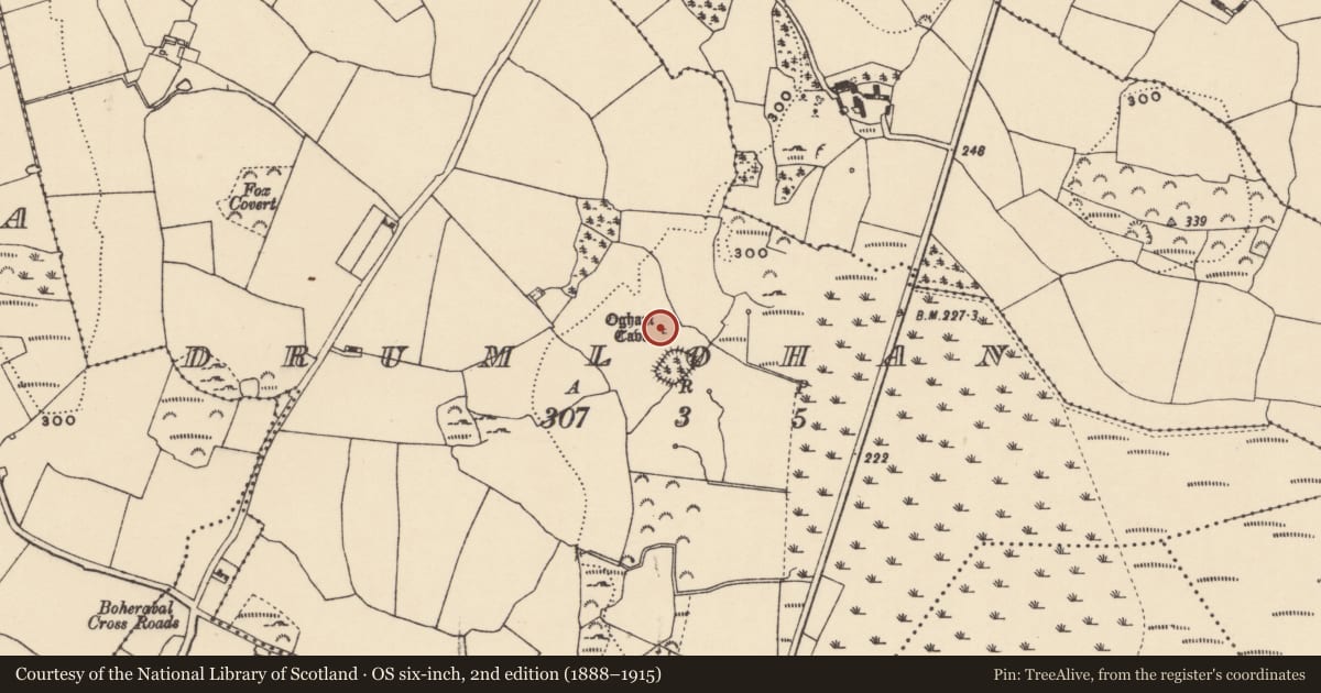
The record
- Townland
- Drumlohan
- County
- Waterford
- Country
- Ireland
- First-edition OS map
- Not indicated
- Latest-edition OS map
- Ogham Cave
- Coordinates
- 52.16328, -7.46535
- SMR number
- WA024-033004-
Slide toward Today to fade the historical sheet and see the modern map underneath.
David Rumsey Map Collection, Stanford LibrariesDavid Rumsey Map Collection, Stanford LibrariesDavid Rumsey Map Collection, Stanford LibrariesDavid Rumsey Map Collection, Stanford Libraries
4 historical maps cover this location, the earliest the 1790 map "Composite: Ireland." (David Rumsey Map Collection, Stanford Libraries).
Historical maps covering this location
- 1790 · Composite: Ireland. (David Rumsey Map Collection, Stanford Libraries)
- 1882 · Ireland (southern half). (David Rumsey Map Collection, Stanford Libraries)
- 1891 · Ireland 16 (David Rumsey Map Collection, Stanford Libraries)
- 1904 · Sheet 13. (David Rumsey Map Collection, Stanford Libraries)
This record in the National Monuments Service's Historic Environment Viewer ↗
The National Monuments Service's description
Discovered during the removal of the outer bank of church site (WA024-033001-) at N in 1868 (Williams 1868-9). Rectangular chamber (dims. 3.35m x 1.5m; H at discovery 1.2m) with orthostatic walls and roofed with eight lintels. Ten ogham stones (WA024-033006- to WA024-033015-), which were utilised as lintels and sidestones, are preserved at the site.
The inscriptions have been read by Macalister (1945, vol. 1, 267-77) as: 1, MANU MAGUNO GATI MOCOI MACORBO; 2, CALUNOVIC[A] MAQI MUCOI LIT[ENI]; 3, MAQI-INI[...MAQI QE]TTEAS; 4, CUNALEGEA MAQI C[...]SALAR CELI AVI QVECI; 5, BIGU MAQI LAG [...]; 6, BIR MAQI MUCOI ROTTIS; 7, ...] MAQI NE[TACUN]AS; 8, DENAVEC[A MU]COI MEDALO; 9, BRO[INION]AS; 10, SOVALINI/ DEAGOS MAQI MUCO[I...]NAI. (Brash 1866-9; Rhys 1899; Kirwan 1985; 1987; Harbison 1992, 325)
The above description is derived from the published 'Archaeological Inventory of County Waterford' (Dublin: Stationery Office, 1999). In certain instances the entries have been revised and updated in the light of recent research.
Compiled by: Michael Moore.
Date of upload/revision: 9th May, 2011.
This monument is subject to a preservation order made under the National Monuments Acts 1930 to 2014 (PO no. 12/1933).
References
Kirwan, E.M. 1987 Drumlohan: a survey of its antiquities. Decies, no. 35, 33-40.
Kirwan, E.M. 1985 The ogham stones at Drumlohan reconsidered. Decies, no. 29, 6-12.
Macalister, R.A.S. 1945 Corpus inscriptionum insularum celticarum. Dublin. Stationery Office.
Harbison, P. 1992 The high crosses of Ireland: an iconographical and photographic survey, 3 vols. Dublin. Royal Irish Academy. Bonn. Dr. Rudolf Habelt GMBH.
Rhys, P. 1899 The Drumloghan ogams. Journal of the Royal Society of Antiquaries of Ireland 29, 390-403.
Brash, R.R. 1868-9 On the Seskinan ogham inscriptions. County of Waterford. Journal of the Royal Society of Antiquaries of Ireland 10, 118-30.
Williams, W. 1868-9 On an ogham chamber at Drumloghan, in the County of Waterford. Journal of the Royal Society of Antiquaries of Ireland 10, 35-9.
Nearby in the register
- Ogham stoneunder 1 mi
- Ogham stoneunder 1 mi
- Ogham stoneunder 1 mi
- Ogham stoneunder 1 mi
Other entries of the same register within about three miles of this one, by straight line.