Sites and Monuments Record · Ireland
Enclosure
Kilbrannel, County Tipperary South, Ireland
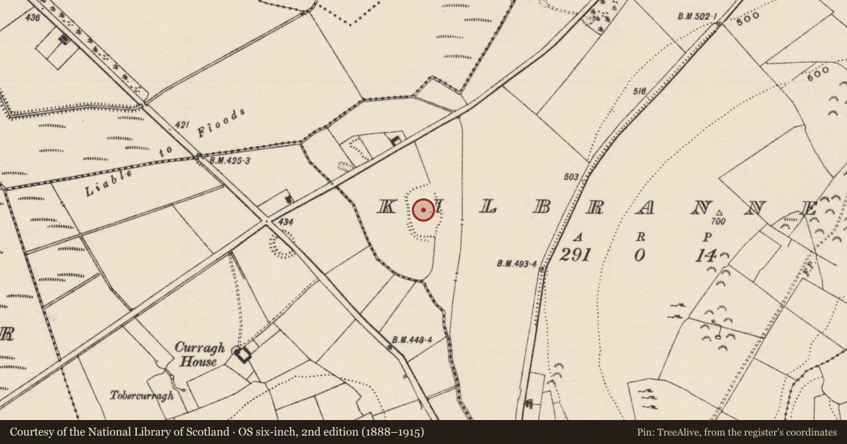
The record
- Townland
- Kilbrannel
- County
- Tipperary South
- Country
- Ireland
- First-edition OS map
- Indicated
- Latest-edition OS map
- Hachured
- Coordinates
- 52.58309, -7.67953
- SMR number
- TS054-028----
Slide toward Today to fade the historical sheet and see the modern map underneath.
David Rumsey Map Collection, Stanford LibrariesDavid Rumsey Map Collection, Stanford LibrariesDavid Rumsey Map Collection, Stanford LibrariesDavid Rumsey Map Collection, Stanford Libraries
4 historical maps cover this location, the earliest the 1790 map "Composite: Ireland." (David Rumsey Map Collection, Stanford Libraries).
Historical maps covering this location
- 1790 · Composite: Ireland. (David Rumsey Map Collection, Stanford Libraries)
- 1869 · Ireland. (David Rumsey Map Collection, Stanford Libraries)
- 1891 · Ireland 16 (David Rumsey Map Collection, Stanford Libraries)
- 1904 · Sheet 13. (David Rumsey Map Collection, Stanford Libraries)
This record in the National Monuments Service's Historic Environment Viewer ↗
The National Monuments Service's description
In grassland on an E-facing slope of N-S ridge in upland area with good views in all directions. Low flat wetland and drain to E of enclosure at base of ridge on top of which the monument is located, stream on other side to W. Large roughly D-shaped area (int. dims. 90m N-S; 60m E-W) enclosed by an earthen bank (top Wth 1.5m; base Wth 4m; int. H 0.4m; ext. H 1-1.5m) and wide external dry fosse (base Wth 3m; top Wth 6m; ext. D 0.7m ) visible from S to W only. Internal bank visible from S through W to N elsewhere it has been reduced to a scarp or destroyed as at N to NE. Enclosing bank intersected by a field bank at E where the bank has been reduced to a tree-lined scarp (H 0.8m). Berm (Wth 8m; ext. H 0.5m) feature running parallel to scarp along base of ridge on E side. Possible drainage feature. No entrance feature visible. Straight side at E defined by a tree-lined scarp (L 85m). Unusual shape and size of enclosure would suggest these is not a ringfort. Modern bungalows to N of site between monument and road.
Compiled by: Jean Farrelly
Date of upload: 26 August 2011
Nearby in the register
- Ringfort - rathunder 1 mi
- Road - road/trackwayunder 1 mi
- Moated siteunder 1 mi
- Enclosureunder 1 mi
Other entries of the same register within about three miles of this one, by straight line.