Sites and Monuments Record · Ireland
Megalithic tomb - portal tomb
Drumanone, County Roscommon, Ireland
The record
- Townland
- Drumanone
- County
- Roscommon
- Country
- Ireland
- First-edition OS map
- Druids Altar
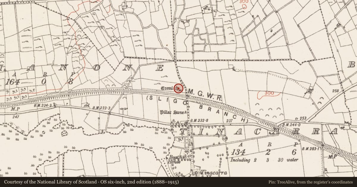
- Latest-edition OS map
- Cromlech
- Coordinates
- 53.97014, -8.35436
- SMR number
- RO005-015----
Slide toward Today to fade the historical sheet and see the modern map underneath.
David Rumsey Map Collection, Stanford LibrariesDavid Rumsey Map Collection, Stanford LibrariesDavid Rumsey Map Collection, Stanford LibrariesDavid Rumsey Map Collection, Stanford Libraries
4 historical maps cover this location, the earliest the 1790 map "Composite: Ireland." (David Rumsey Map Collection, Stanford Libraries).
Historical maps covering this location
- 1790 · Composite: Ireland. (David Rumsey Map Collection, Stanford Libraries)
- 1811 · Ireland. (David Rumsey Map Collection, Stanford Libraries)
- 1869 · Ireland. (David Rumsey Map Collection, Stanford Libraries)
- 1891 · Ireland 16 (David Rumsey Map Collection, Stanford Libraries)
This record in the National Monuments Service's Historic Environment Viewer ↗
The National Monuments Service's description
Situated at the W end of a low E-W rise, c. 200m N of what was the E end of Lower Lough Gara which is now reclaimed. Rectangular chamber (int. dims.2.2m NW-SE; 1.95m NE-SW) facing NE defined by two sidestones and a backstone with two portal stones (H 1.75m; 2.2m) and the septal stone (H 1.9m). The roofstone (dims. 4m NE-SW; 3m NW-SE; T c. 0.7m) is in situ, and a slight grass-covered cairn (dims. c. 7m NW-SE; c. 6m NE-SW) surrounds the stones. Standing stone (RO005-016----) is c. 100m to the S. (de Valera and Ó Nualláin 1972, 32,33)
It has been known and described from the early 19th century (Weld 1832, 278; D'Alton 1845, 81-2; Borlase 1897, vol. 1, 195-7; Clarke 1899, Ó Nualláin 1983, 100) and was excavated and conserved in 1954 (Topp 1962) when cremated human remains, a polished stone axe, two Bann flakes and a chert core were recovered (Herity 1964, 130).
See the attached view from the E
Compiled by: Michael Moore
Date of upload: 24 August 2010
See linked document with details from Ruaidhrí de Valera and Seán Ó Nualláin, Survey of the Megalithic Tombs of Ireland. Volume III. Counties Galway, Roscommon, Leitrim, Longford, Westmeath, Laoighis, Offaly, Kildare, Cavan. (Dublin: Stationery Office, 1972).
References
D'Alton, J. 1845 The history of Ireland: from the earliest period to the year 1245. 2 vol. Dublin, Author.
de Valera, R. and Ó Nualláin, S. 1972 Survey of the megalithic tombs of Ireland, vol. 3, Counties Galway, Roscommon, Leitrim, Longford, Westmeath, Laoighis, Offaly, Kildare, Cavan. Dublin. Stationery Office.
Borlase, W.C. 1897 The Dolmens of Ireland, 3 vols. London. Chapman and Hall.
Clarke, Rev. F.E. 1899 Notes on the Tinnecarra cromlech near Boyle. Proceedings of the Royal Irish Academy 5C, 374-6.
Ó Nualláin, S. 1983 Irish portal tombs, topography, siting and distribution. Journal of the Royal Society of Antiquaries of Ireland 113, 75-105.
Herity, M. 1964 The finds from the Irish portal dolmens. Journal of the Royal Society of Antiquaries of Ireland 94, pt. 2, 123-44.
Weld, I. 1832 Statistical survey of the county Roscommon. Dublin, Royal Dublin Society
Topp, C. 1962 The portal dolmen of Dromanone - Co. Roscommon. Bulletin of the Institute of Archaeology 3, 38-46.
Nearby in the register
- Standing stoneunder 1 mi
- Settlement platformunder 1 mi
- Settlement platformunder 1 mi
- Settlement platformunder 1 mi
Other entries of the same register within about three miles of this one, by straight line.