Sites and Monuments Record · Ireland
Enclosure
Rathlackan, County Mayo, Ireland
The record
- Townland
- Rathlackan
- County
- Mayo
- Country
- Ireland
- First-edition OS map
- Indicated
- Latest-edition OS map
- Childrens burial Ground
- Coordinates
- 54.29191, -9.25726
- SMR number
- MA008-001001-
Slide toward Today to fade the historical sheet and see the modern map underneath.
David Rumsey Map Collection, Stanford LibrariesDavid Rumsey Map Collection, Stanford LibrariesDavid Rumsey Map Collection, Stanford LibrariesDavid Rumsey Map Collection, Stanford Libraries
4 historical maps cover this location, the earliest the 1790 map "Composite: Ireland." (David Rumsey Map Collection, Stanford Libraries).
Historical maps covering this location
- 1790 · Composite: Ireland. (David Rumsey Map Collection, Stanford Libraries)
- 1841 · Ireland. (David Rumsey Map Collection, Stanford Libraries)
- 1869 · Ireland. (David Rumsey Map Collection, Stanford Libraries)
- 1891 · Ireland 16 (David Rumsey Map Collection, Stanford Libraries)
This record in the National Monuments Service's Historic Environment Viewer ↗
The National Monuments Service's description
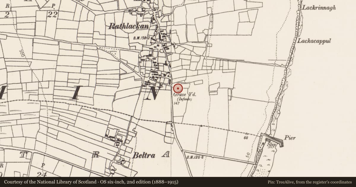
Located on a terrace on an E-facing slope, overlooking Lackan Bay, at the SE edge of the hamlet of Rathlackan.
This enclosure is indicated as ‘Grave Yard’ on the 1838 OS 6-inch map, where it is depicted as a roughly square enclosure, with a rectangular structure or building (MA008-001003-) in the centre; on the 1922 edition it is shown as circular in plan, marked as ‘Children’s Burial Ground’, and the building is not shown.
Circular area (39m N–S; 37.5m E–W) defined by a bank (Wth 3.2m; int. H 0.6m; ext. H 1m at NW) faced in parts with dry-stone walling. The stone facing occurs on both the interior and exterior faces of the bank; at NW it takes the form of a kerb of large stones on the inner face. Some of the stone facing appears to be the result of incorporation of the enclosure into a system of later field walls. There is a break (Wth 6m) in the bank at W, but no clearly defined entrance feature.
The interior appears slightly raised relative to exterior ground level. A low square platform in the centre of the interior may be the foundations of a building/church (MA008-001003-). According to local tradition, the enclosure was used as a children’s burial ground (MA008-001002-), and was traditionally known as ‘Killwee’ (Aldridge 1969, 85).
Compiled by: Jane O'Shaughnessy
Date of upload: 1 July 2019
References
Aldridge, R.B. 1969 Notes on children's burial grounds in Mayo. Journal of the Royal Society of Antiquaries of Ireland 99, 83-87.
Nearby in the register
- Children's burial groundunder 1 mi
- Churchunder 1 mi
- Buildingunder 1 mi
- Middenunder 1 mi
Other entries of the same register within about three miles of this one, by straight line.