Sites and Monuments Record · Ireland
Cross - High cross
Kilfenora, County Clare, Ireland
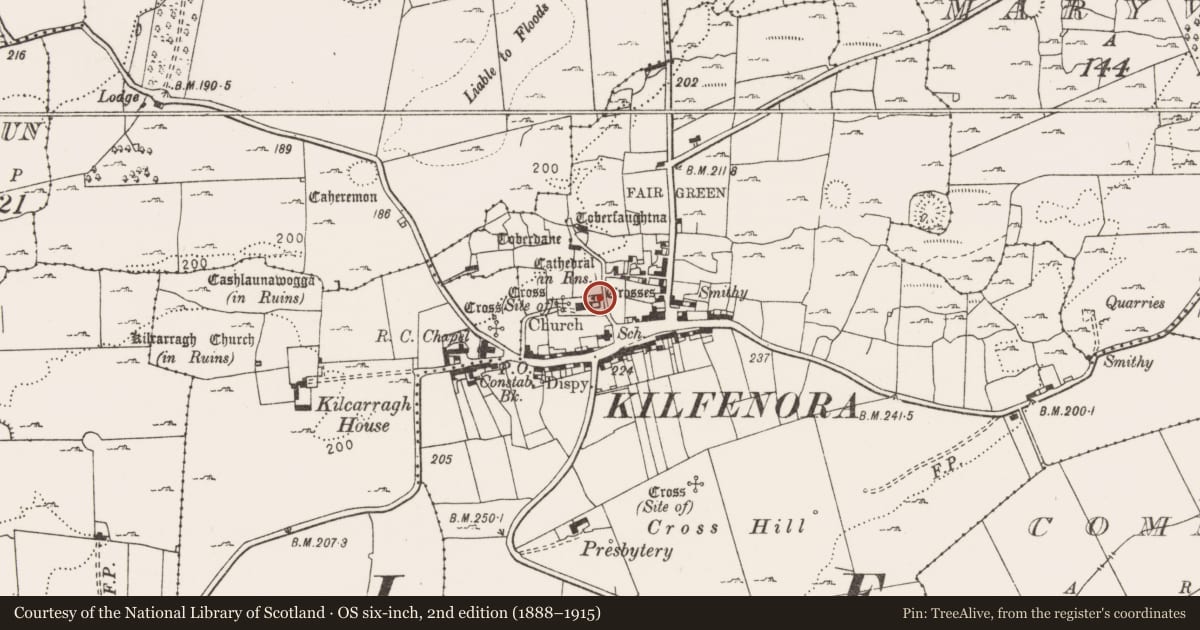
The record
- Townland
- Kilfenora
- County
- Clare
- Country
- Ireland
- First-edition OS map
- Cross
- Latest-edition OS map
- S.S. (Site of) (1916)
- Coordinates
- 52.99073, -9.21682
- SMR number
- CL016-015006-
Slide toward Today to fade the historical sheet and see the modern map underneath.
David Rumsey Map Collection, Stanford LibrariesDavid Rumsey Map Collection, Stanford LibrariesDavid Rumsey Map Collection, Stanford LibrariesDavid Rumsey Map Collection, Stanford Libraries
4 historical maps cover this location, the earliest the 1753 map "Mappa geographica Regni Hiberniae" (David Rumsey Map Collection, Stanford Libraries).
Historical maps covering this location
- 1753 · Mappa geographica Regni Hiberniae (David Rumsey Map Collection, Stanford Libraries)
- 1790 · Composite: Ireland. (David Rumsey Map Collection, Stanford Libraries)
- 1869 · Ireland. (David Rumsey Map Collection, Stanford Libraries)
- 1891 · Ireland 16 (David Rumsey Map Collection, Stanford Libraries)
This record in the National Monuments Service's Historic Environment Viewer ↗
The National Monuments Service's description
Erected c. 2006 in the middle of the ‘sacristy’ situated N of the chancel in Kilfenora Cathedral (CL016-015002-) due to weathering. Listed in the SMR (1992) and the RMP (1996) as ‘Cross’. This is the 12th-century high cross known as the ‘Doorty’ cross which formerly stood in the graveyard (CL016-015003-) W of the church. It was one of originally 6 limestone high crosses at Kilfenora, five of which are still there (see CL016-015005-, CL016-015007-, CL016-015008-, and CL016-015013-) and one of which was moved to Killaloe in 1821 (CL045-033009-). This cross is constructed from fragments found c. 1956 and later. The lower part was used upside-down by the Doorty family as a tombstone, hence the name. The cross (H 2.83m; Wth 0.75m across the arms) has a tapering shaft (Wth 0.56m at the bottom; T 0.19m) and has an imperforate uneven ringed head. Harbison (1992, vol. 1, 114-15) describes the carved images as follows: E face (now facing W), lower portion: Two clerics, likely to be St. Anthony and St. Paul linking arms, one holding a drop-headed crozier, the other a T-headed one, over a winged beast. Upper portion: An unidentified bishop or abbot (possibly St. Fachtnan, the founder of the church at Kilfenora). S face (now facing N): Above a single human head is a figure with right hand down by the side and with the left hand placed across the chest, holding a book. Above is interlace. W face (now facing E), lower portion: A horseman on top of a shingled roof with ornamental scrolls interlaced by a narrow-bodied animal above. Upper portion: A badly worn crucified Christ. N face (now facing S): An irregular interlace on the shaft surmounted by a chequer-board pattern. (See Harbison 1992 for detailed description.) This is a national monument in State care, no. 8. (de Paor, 1955-6, 55-8)
The following images have been uploaded:
CL016-015006-_01.jpg The Doorty cross, E face (after Harbison) in its former location in the graveyard.
CL016-015006-_02.jpg The lower portion of the E face (after Harbison) of the Doorty cross now housed in the cathedral.
CL016-015006-_03.jpg The Doorty cross, W face (after Harbison) in the glass-roofed 'sacristy' of the cathedral.
CL026-015006-_04.jpg The Doorty cross, S face (after Harbison).
Compiled by: Mary Tunney
Date of upload: 19 September 2017
References
Harbison, P. 1992 The high crosses of Ireland: an iconographical and photographic survey, 3 vols. Dublin. Royal Irish Academy. Bonn. Dr. Rudolf Habelt GMBH.
De Paor, L. 1955 The limestone crosses of Clare and Aran. Journal of the Galway Archaeological and Historical Society 26, 53-71.
Nearby in the register
- Cross - High crossunder 1 mi
- Cross - High crossunder 1 mi
- Cross - High crossunder 1 mi
- Wall monumentunder 1 mi
Other entries of the same register within about three miles of this one, by straight line.