Cof Cymru: National Historic Assets of Wales · Wales
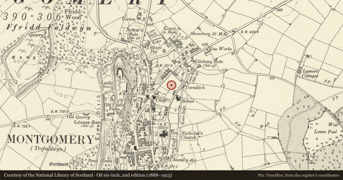
Montgomery Medieval Town, Part adjacent to Westmead, School Lane
Montgomery, Powys, Wales
A scheduled monument in Montgomery, Powys, recorded as Town (Medieval).
The record
- Designation
- Scheduled monument
- Site type
- Town
- Period
- Medieval
- Date of designation
- 4 January 1993
- Community
- Montgomery
- Unitary authority
- Powys
- Country
- Wales
- Coordinates (centre of the scheduled area)
- 52.56315, -3.14618
- SAM number
- MG221
- Cadw record number
- 2649
Slide toward Today to fade the historical sheet and see the modern map underneath.
David Rumsey Map Collection, Stanford LibrariesDavid Rumsey Map Collection, Stanford LibrariesDavid Rumsey Map Collection, Stanford LibrariesLlyfrgell Genedlaethol Cymru – The National Library of WalesDavid Rumsey Map Collection, Stanford Libraries
5 historical maps cover this location, the earliest the 1637 map "Particular description of Wales. Cambria seu Wallia" (David Rumsey Map Collection, Stanford Libraries).
Historical maps covering this location
- 1637 · Particular description of Wales. Cambria seu Wallia (David Rumsey Map Collection, Stanford Libraries)
- 1795 · To Sir Watkin Williams-Wynn Bart ... the map of the six counties of North Wales is most… (Llyfrgell Genedlaethol Cymru – The National Library of Wales)
- 1883 · Watershed map England, Wales 3. (David Rumsey Map Collection, Stanford Libraries)
- 1899 · 165 Montgomery (Hills) (David Rumsey Map Collection, Stanford Libraries)
- 1901 · Sheet 14. (David Rumsey Map Collection, Stanford Libraries)
Cadw's description
Summary description and reason for designation
The following provides a general description of the scheduled monument.
The monument consists of a town, dating to the medieval period. An evaluation excavation in 1992 revealed evidence related to medieval settlement including remains of timber-framed buildings, with pottery dateable to 13th/14th centuries.
The monument is of national importance for its potential to enhance our knowledge of Roman/medieval urban organisation and of the growth of towns. The monument forms an important element within the wider medieval context and the structure itself may be expected to contain archaeological information in regard to chronology, building techniques and functional detail.
The scheduled area comprises the remains described and areas around them within which related evidence may be expected to survive.
Nearby in the register
- White CroftDomesticunder 1 mi
- Montgomery Primary SchoolEducationunder 1 mi
- No. 4 Cross HousesDomesticunder 1 mi
- No. 3 Cross HousesDomesticunder 1 mi
Other entries of the same register within about three miles of this one, by straight line.