Cof Cymru: National Historic Assets of Wales · Wales
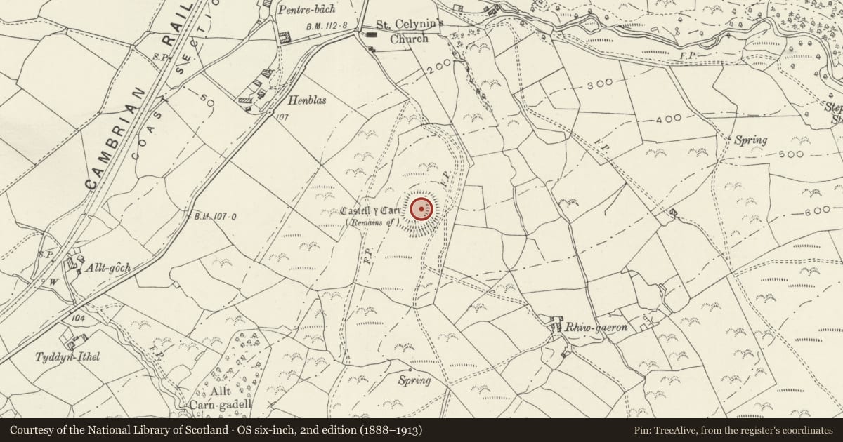
Castell y Gaer
Llangelynin, Gwynedd, Wales
A scheduled monument in Llangelynin, Gwynedd, recorded as Hillfort (Prehistoric).
The record
- Designation
- Scheduled monument
- Site type
- Hillfort
- Period
- Prehistoric
- Community
- Llangelynin
- Unitary authority
- Gwynedd
- Country
- Wales
- Coordinates (centre of the scheduled area)
- 52.66061, -4.08315
- SAM number
- ME053
- Cadw record number
- 216
Slide toward Today to fade the historical sheet and see the modern map underneath.
David Rumsey Map Collection, Stanford LibrariesDavid Rumsey Map Collection, Stanford LibrariesDavid Rumsey Map Collection, Stanford LibrariesLlyfrgell Genedlaethol Cymru – The National Library of WalesDavid Rumsey Map Collection, Stanford Libraries
5 historical maps cover this location, the earliest the 1795 map "To Sir Watkin Williams-Wynn Bart ... the map of the six counties of North Wales is most humbly inscribed by his obedient humble servant" (Llyfrgell Genedlaethol Cymru – The National Library of Wales).
Historical maps covering this location
- 1795 · To Sir Watkin Williams-Wynn Bart ... the map of the six counties of North Wales is most… (Llyfrgell Genedlaethol Cymru – The National Library of Wales)
- 1883 · Watershed map England, Wales 3. (David Rumsey Map Collection, Stanford Libraries)
- 1896 · Sheet 7. Ordnance Survey of England and Wales. (David Rumsey Map Collection, Stanford Libraries)
- 1899 · 149 Barmouth (Hills) (David Rumsey Map Collection, Stanford Libraries)
- 1901 · Sheet 9 and 10. (David Rumsey Map Collection, Stanford Libraries)
Cadw's description
Summary description and reason for designation
The following provides a general description of the Scheduled Monument.
The monument comprises the remains of a hillfort, which probably dates to the Iron Age period (c. 800 BC - AD 74, the Roman conquest of Wales). Hillforts are usually located on hilltops and surrounded by a single or multiple earthworks of massive proportions. Hillforts must have formed symbols of power within the landscape, while their function may have had as much to do with ostentation and display as defence. Castell-y-Gaer occupies a small rounded spur on the south side of the Afon Gwril. The central enclosure is a rather rectilinear oval, about 60m north-south by 30-44m, defined by scarps above steep natural slopes on the west and north, and enclosed on the south and east by a robbed and disturbed stony bank c.6.0m across. Outside this, still on the south and east, is a further line of defence which takes the form of a second bank outside a ditch on the south, but which peters out to be little more than a platform with a scarped outer edge further north. The southern end of the scarp runs outside the northern end of the bank on the east side, forming the outer portion of a complex entrance which runs a short distance to the south between the two lines of defences before crossing into the inner enclosure. Around the southern arc a further ditch is present outside the second bank.
The monument is of national importance for its potential to enhance our knowledge of later prehistoric defensive organisation and settlement. The site forms an important element within the wider later prehistoric context and within the surrounding landscape. The site is well preserved and retains considerable archaeological potential. There is a strong probability of the presence of evidence relating to chronology, building techniques and functional detail.
The scheduled area comprises the remains described and areas around them within which related evidence may be expected to survive.
Nearby in the register
- Service building and garage at Ty Gwyn, including attached courtyard wallsNo class recordedunder 1 mi
- Ty Gwyn Outdoor Education CentreNo class recordedunder 1 mi
- Church of St CelyninNo class recordedunder 1 mi
- Llwyngwril war memorialNo class recordedunder 1 mi
Other entries of the same register within about three miles of this one, by straight line.