Cof Cymru: National Historic Assets of Wales · Wales
Bachwen Burial Chamber
Clynnog, Gwynedd, Wales
A scheduled monument in Clynnog, Gwynedd, recorded as Chambered Long Cairn (Prehistoric).
The record
- Designation
- Scheduled monument
- Site type
- Chambered Long Cairn
- Period
- Prehistoric
- Community
- Clynnog
- Unitary authority
- Gwynedd
- Country
- Wales
- Coordinates (centre of the scheduled area)
- 53.01891, -4.37525
- SAM number
- CN008
- Cadw record number
- 3155
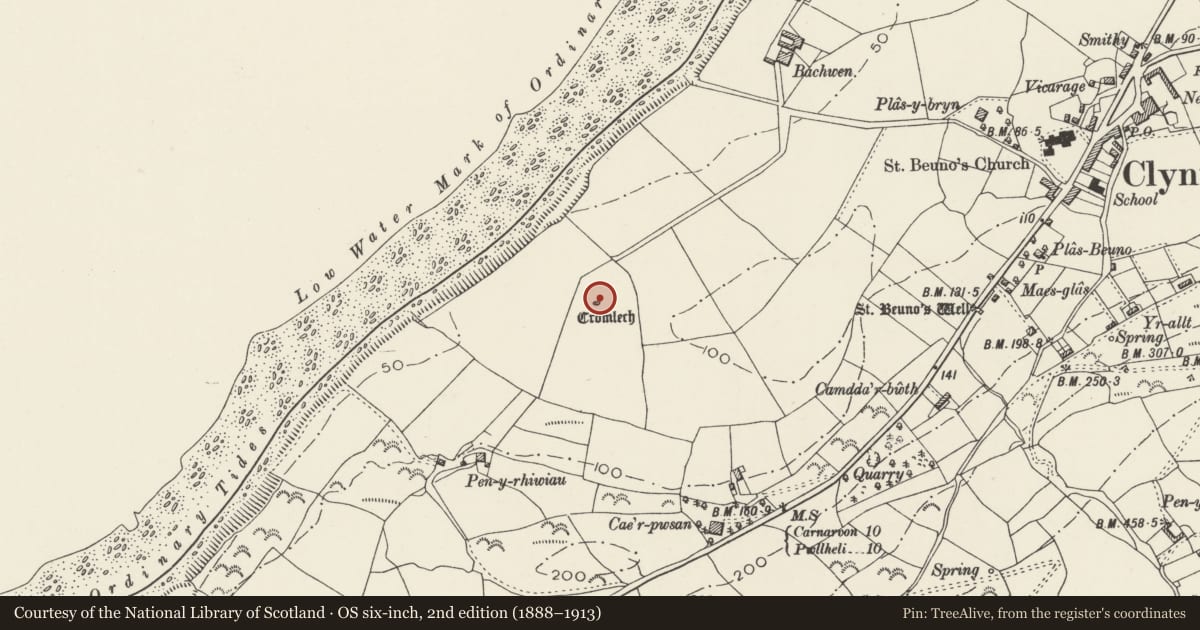
Slide toward Today to fade the historical sheet and see the modern map underneath.
David Rumsey Map Collection, Stanford LibrariesDavid Rumsey Map Collection, Stanford LibrariesDavid Rumsey Map Collection, Stanford LibrariesDavid Rumsey Map Collection, Stanford LibrariesLlyfrgell Genedlaethol Cymru – The National Library of Wales
5 historical maps cover this location, the earliest the 1795 map "To Sir Watkin Williams-Wynn Bart ... the map of the six counties of North Wales is most humbly inscribed by his obedient humble servant" (Llyfrgell Genedlaethol Cymru – The National Library of Wales).
Historical maps covering this location
- 1795 · To Sir Watkin Williams-Wynn Bart ... the map of the six counties of North Wales is most… (Llyfrgell Genedlaethol Cymru – The National Library of Wales)
- 1883 · Watershed map England, Wales 3. (David Rumsey Map Collection, Stanford Libraries)
- 1896 · Sheet 7. Ordnance Survey of England and Wales. (David Rumsey Map Collection, Stanford Libraries)
- 1899 · 118 Nevin (Hills) (David Rumsey Map Collection, Stanford Libraries)
- 1901 · Sheet 9 and 10. (David Rumsey Map Collection, Stanford Libraries)
Cadw's description
Summary description and reason for designation
The following provides a general description of the Scheduled Monument.
The monument consists of the remains of a chambered long cairn, dating to early Neolithic (c.4,200BC - 3,000BC). A long cairn is a roughly rectangular or trapezoidal mound of stone, usually between 25m and 120m long, with a length exceeding twice its greatest width. The mound may be edged with a timber or stone revetment, and they contain one or more stone or wooden burial chambers at one end.
This small tomb is aligned east to west and stands in the centre of a field overlooking the sea. It consists of four uprights, c.1.1m high supporting a triangular capstone whose maximum dimensions are 2.5m long, 1.3m wide and 0.5m thick. The southern upright of the chamber is a modern replacement. A raised area around the stones denotes the remains of cairn material. The monument is best known for its decorated capstone with 110 cup-marks and two shallow grooves. Eight other cups occur on the east side of the capstone. The chamber was excavated in 1876; nothing of interest was recorded during that excavation.
The monument is of national importance for its potential to enhance our knowledge of prehistoric burial and ritual practices. The features are an important relic of a prehistoric funerary and ritual landscape and retain significant environmental and structural evidence. Chambered long cairns may be part of a larger cluster of monuments and their importance can further enhanced by their group value.
The scheduled area comprises the remains described and areas around them.
Nearby in the register
- Ffynnon BeunoWater Supply and Drainageunder 1 mi
- St Beuno's WellHoly Wellunder 1 mi
- Maes-glasDomesticunder 1 mi
- Former SW wing of BodfasarnDomesticunder 1 mi
Other entries of the same register within about three miles of this one, by straight line.