Cof Cymru: National Historic Assets of Wales · Wales
Carmarthen House
Carmarthen, Carmarthenshire, Wales
A Grade II listed building in Dark Gate, Carmarthen, Carmarthenshire, designated on 19 May 1981.
The record
- Designation
- Listed building, Grade II
- Broad class
- Commercial
- Date of designation
- 19 May 1981
- Locality
- Dark Gate
- Community
- Carmarthen
- Unitary authority
- Carmarthenshire
- Country
- Wales
- Coordinates
- 51.85632, -4.30857
- Cadw reference
- 9443
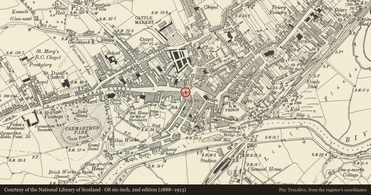
Slide toward Today to fade the historical sheet and see the modern map underneath.
David Rumsey Map Collection, Stanford LibrariesDavid Rumsey Map Collection, Stanford LibrariesDavid Rumsey Map Collection, Stanford LibrariesDavid Rumsey Map Collection, Stanford LibrariesDavid Rumsey Map Collection, Stanford Libraries
5 historical maps cover this location, the earliest the 1636 map "Cornubia : Devonia, Somersetus, Dorcestria, Wiltonia, Glocestria ..." (David Rumsey Map Collection, Stanford Libraries).
Historical maps covering this location
- 1636 · Cornubia : Devonia, Somersetus, Dorcestria, Wiltonia, Glocestria ... (David Rumsey Map Collection, Stanford Libraries)
- 1860 · 41. Caermathen. (David Rumsey Map Collection, Stanford Libraries)
- 1891 · Sheet 10. Ordnance Survey of England and Wales. . (David Rumsey Map Collection, Stanford Libraries)
- 1898 · 229 Carmarthen (Hills) (David Rumsey Map Collection, Stanford Libraries)
- 1901 · Sheet 14. (David Rumsey Map Collection, Stanford Libraries)
Cadw's description
Location
Situated on junction with Mill Steet, attached to No 8 to left.
History
Town house probably of mid to later C18 date, much altered, now commercial premises. Once known as Gellingham House, it was described in will of Morgan Lewis and in advert for sale in 1812, and partly rebuilt in 1844 for Dr J.P. Watkins, though the lost interior features suggest the fabric remained mostly of C18 date. In 1914 occupied by Cash & Co, bootsellers, from 1959 Messrs Burgess jewellers in the ground floor, the shop extended to first floor in 1982, and all interior detail mentioned in 1981 listing lost.
A photograph of 1937 on premises shows that the house once had an eaves cornice and was of five bays, with windows in centre.
Exterior
End terrace commercial premises. Painted stucco with close-eaved slate roof and left end stack, right stack removed since 1981. Three storeys, four bays. Two hipped sash dormers and moulded eaves cornice removed since 1981. Windows are grouped in pairs each side, (former central windows lost) 4-pane sashes to upper floors, square to top floor, set well below eaves. Thin sill band at second floor. Ground floor formerly 2 shopfronts, late C19 to early C20 to left, C20 to right, now all one late C20 . Windowless stuccoed end walls. Lower rear wing of 3 storeys and attic, with eaves roof. Two bays, set to centre right, 4-pane attic sash in centre under eaves, 2 12-pane horned sashes to second floor and one to first floor right. Blocked low door to ground floor right and narrow louvred window to right again.
Rear right of main building is rubble stone with altered window to each upper floor, brickwork between and above windows.
Interior
The interior listed in 1981 has been lost with possible exception of attic. The 1981 description listed: fielded 6-panel doors with L-hinges. C18 staircase in early to mid C18 London style with turned balusters, moulded rail and continuous pulvinated string from first floor to attic; dado panelling above wall string. In E second floor room, mid C18 fireplace with eared architrave. On first floor, W room with C18 cornice with modillions and dentils, late C19 fireplace with eared C18 overmantel, C18 cupboards in W wall incorporating semi-circular arched cupboard with shaped shelves. E room with C18 cornice. Attic in need of attention.
Reason for designation
Included despite alterations since 1981 as remnant of a C18 town house of group value with Nos 8-9 Dark Gate.
Nearby in the register
- 8-9Commercialunder 1 mi
- 1Domesticunder 1 mi
- 36 Blue StreetDomesticunder 1 mi
- 11 Guildhall SquareCommercialunder 1 mi
Other entries of the same register within about three miles of this one, by straight line.