Cof Cymru: National Historic Assets of Wales · Wales
Stable & Coach-house to rear of Wynnstay Arms Hotel
Ruthin, Denbighshire, Wales
A Grade II listed building in Well Street, Ruthin, Denbighshire, designated on 30 December 2005.
The record
- Designation
- Listed building, Grade II
- Broad class
- No class recorded
- Date of designation
- 30 December 2005
- Locality
- Well Street
- Town
- Ruthin
- Community
- Ruthin
- Unitary authority
- Denbighshire
- Country
- Wales
- Coordinates
- 53.11355, -3.30848
- Cadw reference
- 87350
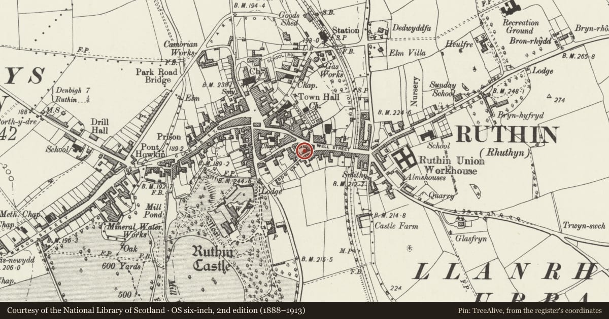
Slide toward Today to fade the historical sheet and see the modern map underneath.
David Rumsey Map Collection, Stanford LibrariesDavid Rumsey Map Collection, Stanford LibrariesLlyfrgell Genedlaethol Cymru – The National Library of WalesDavid Rumsey Map Collection, Stanford LibrariesDavid Rumsey Map Collection, Stanford Libraries
5 historical maps cover this location, the earliest the 1795 map "To Sir Watkin Williams-Wynn Bart ... the map of the six counties of North Wales is most humbly inscribed by his obedient humble servant" (Llyfrgell Genedlaethol Cymru – The National Library of Wales).
Historical maps covering this location
- 1795 · To Sir Watkin Williams-Wynn Bart ... the map of the six counties of North Wales is most… (Llyfrgell Genedlaethol Cymru – The National Library of Wales)
- 1830 · V.3:11-15:XV. Britisches Reich. A. Kon: England. b. Frstenthum Wales: Shire: 37-40 (David Rumsey Map Collection, Stanford Libraries)
- 1883 · Watershed map England, Wales 3. (David Rumsey Map Collection, Stanford Libraries)
- 1898 · 108 Flint (Hills) (David Rumsey Map Collection, Stanford Libraries)
- 1901 · Sheet 9 and 10. (David Rumsey Map Collection, Stanford Libraries)
Cadw's description
Location
Facing E into the rear courtyard of the hotel which has a cobbled floor. The hotel fronts Well Street, but access to the courtyard is from Dog Lane.
History
Probably late-C18 to early-C19 in its current form. The range probably replaces earlier buildings in the yard, the hotel itself dating back to the late C16. Shown on the Ordnance Survey of 1874.
Exterior
Single-storey stable and coach-house range constructed of coursed limestone on a rubble plinth under an old slate roof, hipped to S end. The masonry blocks are largest at the base, becoming progressively smaller towards eaves. The front has stable to L and carriage bays to R. Stable has boarded door to R and window opening to L, both under segmental heads of stone voussoirs; further window opening to S end, immediately under the eaves; both window openings are boarded over. To R of stable, 2 carriage bays divided by a stone pier, each containing double boarded doors and timber lintels immediately under the eaves. Second stone pier to R, beyond which are 2 pairs of double boarded doors immediately under the eaves and separated by a timber post. North end is adjoined by a higher stone range; rear abuts boundary wall to library.
Interior
Interior not inspected.
Reason for designation
Listed as a stable and coach-house block with distinctive stone-work, retaining original character, and part of a group with the Wynnstay Arms Hotel.
Nearby in the register
- Wynnstay Arms HotelCommercialunder 1 mi
- WayfarerCommercialunder 1 mi
- Police Station including forecourt walls & railings.No class recordedunder 1 mi
- Ruthin LibraryCivilunder 1 mi
Other entries of the same register within about three miles of this one, by straight line.