Cof Cymru: National Historic Assets of Wales · Wales
The Fishguard Arms Inn
Haverfordwest, Pembrokeshire, Wales
A Grade II listed building in Haverfordwest, Pembrokeshire, designated on 1 July 1974.
The record
- Designation
- Listed building, Grade II
- Broad class
- Commercial
- Date of designation
- 1 July 1974
- Town
- Haverfordwest
- Community
- Haverfordwest
- Unitary authority
- Pembrokeshire
- Country
- Wales
- Coordinates
- 51.80382, -4.96919
- Cadw reference
- 87041
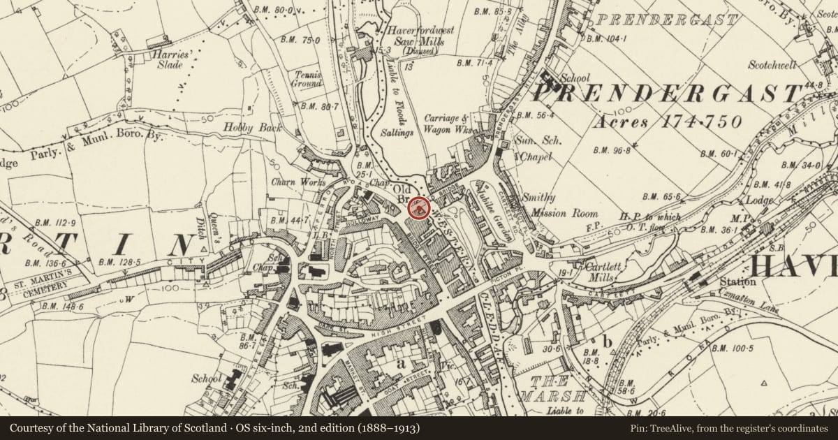
Slide toward Today to fade the historical sheet and see the modern map underneath.
David Rumsey Map Collection, Stanford LibrariesDavid Rumsey Map Collection, Stanford LibrariesDavid Rumsey Map Collection, Stanford LibrariesDavid Rumsey Map Collection, Stanford LibrariesDavid Rumsey Map Collection, Stanford Libraries
5 historical maps cover this location, the earliest the 1608 map "(13) Cambriae Typus." (David Rumsey Map Collection, Stanford Libraries).
Historical maps covering this location
- 1608 · (13) Cambriae Typus. (David Rumsey Map Collection, Stanford Libraries)
- 1636 · Cornubia : Devonia, Somersetus, Dorcestria, Wiltonia, Glocestria ... (David Rumsey Map Collection, Stanford Libraries)
- 1891 · Sheet 10. Ordnance Survey of England and Wales. . (David Rumsey Map Collection, Stanford Libraries)
- 1898 · 228 Haverfordwest (Hills) (David Rumsey Map Collection, Stanford Libraries)
- 1901 · Sheet 13. (David Rumsey Map Collection, Stanford Libraries)
Cadw's description
Location
Situated at right end of short terraced row, also known as Old Bridge, at SW corner of the Old Bridge.
History
Early to mid C19 large inn in short terraced row, presumably on ancient site by the Old Bridge. Marked as an inn on 1888 O.S. In Sir Richard Colt Hoare's c.1800 view of the Old Bridge the inn may be the building shown with catslide roofs over eaves-breaking upper windows.
Exterior
Inn, painted stucco with slate close-eaved roof and small brick left end stack. Gutter carried on corbels. Three storeys, four bays, the second bay had only the original door (which in 1974 had chamfered jambs, flush-panelled 6-panel door and traceried overlight), since replaced by a window to match those to left and right. The other three bays have original square 6-pane sashes to top floor, renewed plate glass first floor sashes, of slightly different lengths, that to left bay the shortest, and ground floor smaller plate-glass sash windows of even size. Left end gable faces river and has one-window range with door to left.
Interior
Ground floor interior altered.
Reason for designation
Included for its special architectural interest in an important position at an abutment of the Old Bridge.
Nearby in the register
- 45 Bridge StreetDomesticunder 1 mi
- 43 Bridge StreetDomesticunder 1 mi
- Telephone Call-box on NW abutment of Old BridgeCommunicationsunder 1 mi
- The Old BridgeTransportunder 1 mi
Other entries of the same register within about three miles of this one, by straight line.