Cof Cymru: National Historic Assets of Wales · Wales
21 Pencei (Cornhill)
Porthmadog, Gwynedd, Wales
A Grade II listed building in Porthmadog, Gwynedd, designated on 1 April 1974.
The record
- Designation
- Listed building, Grade II
- Broad class
- No class recorded
- Date of designation
- 1 April 1974
- Locality
- Porthmadog
- Town
- Porthmadog
- Community
- Porthmadog
- Unitary authority
- Gwynedd
- Country
- Wales
- Coordinates
- 52.92410, -4.13056
- Cadw reference
- 85326
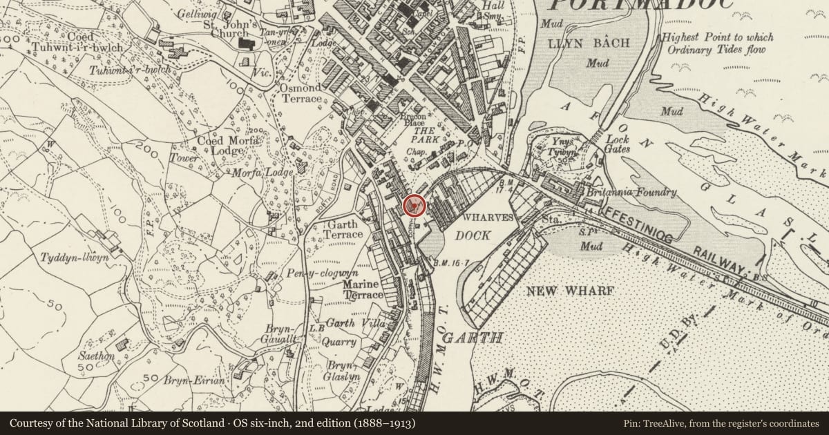
Slide toward Today to fade the historical sheet and see the modern map underneath.
David Rumsey Map Collection, Stanford LibrariesDavid Rumsey Map Collection, Stanford LibrariesDavid Rumsey Map Collection, Stanford LibrariesLlyfrgell Genedlaethol Cymru – The National Library of WalesDavid Rumsey Map Collection, Stanford Libraries
5 historical maps cover this location, the earliest the 1795 map "To Sir Watkin Williams-Wynn Bart ... the map of the six counties of North Wales is most humbly inscribed by his obedient humble servant" (Llyfrgell Genedlaethol Cymru – The National Library of Wales).
Historical maps covering this location
- 1795 · To Sir Watkin Williams-Wynn Bart ... the map of the six counties of North Wales is most… (Llyfrgell Genedlaethol Cymru – The National Library of Wales)
- 1883 · Watershed map England, Wales 3. (David Rumsey Map Collection, Stanford Libraries)
- 1896 · Sheet 7. Ordnance Survey of England and Wales. (David Rumsey Map Collection, Stanford Libraries)
- 1899 · 119 Snowdon (Hills) (David Rumsey Map Collection, Stanford Libraries)
- 1901 · Sheet 9 and 10. (David Rumsey Map Collection, Stanford Libraries)
Cadw's description
Location
On the corner of Cornhill and Lombard Street.
History
Cornhill is the group of buildings around the original Porthmadog harbour (Cornhill Wharf), which was built 1821-4. It became the commercial centre of the port and in 1833 Samuel Lewis noted that 'many good houses have been built, and a considerable trade is now carried on'. Buildings in Cornhill included houses, shops, bank, offices and workshops. In 1886 there were sail makers, 2 block and spar makers, 2 public houses, 4 grocers, butcher, ironmonger and a shipsmith. In addition, the Bwlch-y-Slate Quarry Co, Carnarvonshire & Merionethshire Steamship Co, Workmen's Benefit Building Society, Davies Brothers Slate Merchants, Parry & Co and Prichard Brothers ship brokers all had offices in Cornhill.
No 21 was built in the second quarter of the C19 and shown on the 1842 Tithe map, 1871 Tremadog estate plan and 1888 Ordnance Survey.
Exterior
A 3-storey corner house built in a range with No 20 Cornhill and Nos 1-3 Lombard Street, of whitened scribed roughcast, slate roof hipped to the corner, and stone end stack to the longer Lombard Street front. Single-window fronts to Cornhill and Lombard Street have 2-pane sash windows. The entrance is in the corner, splayed in the lower storey and corbelled out above. It has a replacement half-glazed door. In the Lombard Street elevation, 'Lombard Street' is inscribed into the roughcast, although now painted over.
Interior
Not inspected.
Reason for designation
Listed for its special architectural interest as part of a prominent building in the commercial centre of the port retaining definite C19 character, and for its contribution to the historical integrity of Porthmadog harbour.
Nearby in the register
- 20 Pencei (Cornhill)Domesticunder 1 mi
- Cadw Mei Ce and houseNo class recordedunder 1 mi
- 19 Pencei (Cornhill)No class recordedunder 1 mi
- AwelforNo class recordedunder 1 mi
Other entries of the same register within about three miles of this one, by straight line.