Cof Cymru: National Historic Assets of Wales · Wales
17 Sgwar y Farchnad (High Street)
Porthmadog, Gwynedd, Wales
A Grade II listed building in Tremadog, Porthmadog, Gwynedd, designated on 30 March 1951.
The record
- Designation
- Listed building, Grade II
- Broad class
- No class recorded
- Date of designation
- 30 March 1951
- Locality
- Tremadog
- Community
- Porthmadog
- Unitary authority
- Gwynedd
- Country
- Wales
- Coordinates
- 52.93995, -4.14086
- Cadw reference
- 85319
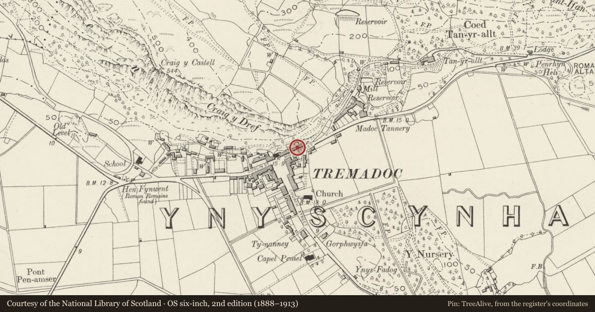
Slide toward Today to fade the historical sheet and see the modern map underneath.
David Rumsey Map Collection, Stanford LibrariesDavid Rumsey Map Collection, Stanford LibrariesDavid Rumsey Map Collection, Stanford LibrariesLlyfrgell Genedlaethol Cymru – The National Library of WalesDavid Rumsey Map Collection, Stanford Libraries
5 historical maps cover this location, the earliest the 1795 map "To Sir Watkin Williams-Wynn Bart ... the map of the six counties of North Wales is most humbly inscribed by his obedient humble servant" (Llyfrgell Genedlaethol Cymru – The National Library of Wales).
Historical maps covering this location
- 1795 · To Sir Watkin Williams-Wynn Bart ... the map of the six counties of North Wales is most… (Llyfrgell Genedlaethol Cymru – The National Library of Wales)
- 1883 · Watershed map England, Wales 3. (David Rumsey Map Collection, Stanford Libraries)
- 1896 · Sheet 7. Ordnance Survey of England and Wales. (David Rumsey Map Collection, Stanford Libraries)
- 1899 · 119 Snowdon (Hills) (David Rumsey Map Collection, Stanford Libraries)
- 1901 · Sheet 9 and 10. (David Rumsey Map Collection, Stanford Libraries)
Cadw's description
Location
One of a pair of houses fronting the street to the E of Market Square.
History
Tremadog was the creation of William Madocks (1773-1828), the first phase of which was built in the first decade of the C19 century. Nos 15-17 High Street were built in the mid C19 and are shown on the 1871 Tremadog estate plan and 1888 Ordnance Survey.
Exterior
Belongs to a group of 15-17 High Street, Tremadog.
A pair of 2-storey double-fronted houses, of large blocks of local quarried stone laid in regular courses, renewed slate roof with added skylights, and stone stacks to the centre and L. No 15 has a central half-glazed door and top-hung windows replaced in original openings. No 17 has a replacement half-glazed door and 2-pane sash windows in original openings. Both have a blind central window in the upper storey.
Interior
Not inspected.
Reason for designation
Listed as one of a pair of houses, notable for its distinctive use of local stone, retaining definite C19 regional character and for its contribution to the historical integrity of Tremadog.
Nearby in the register
- BodlondebDomesticunder 1 mi
- 19 Sgwar y Farchnad (High Street)Domesticunder 1 mi
- 21 Sgwar y Farchnad (High Street)No class recordedunder 1 mi
- 13 Sgwar y Farchnad (High Street)No class recordedunder 1 mi
Other entries of the same register within about three miles of this one, by straight line.