Cof Cymru: National Historic Assets of Wales · Wales
Lodge of Haberdashers' Monmouth School for Girls
Monmouth, Monmouthshire, Wales
A Grade II listed building in Monmouth, Monmouthshire, designated on 16 May 2002.
The record
- Designation
- Listed building, Grade II
- Broad class
- Domestic
- Date of designation
- 16 May 2002
- Locality
- Monmouth
- Town
- Monmouth
- Community
- Monmouth
- Unitary authority
- Monmouthshire
- Country
- Wales
- Coordinates
- 51.81687, -2.71282
- Cadw reference
- 85209
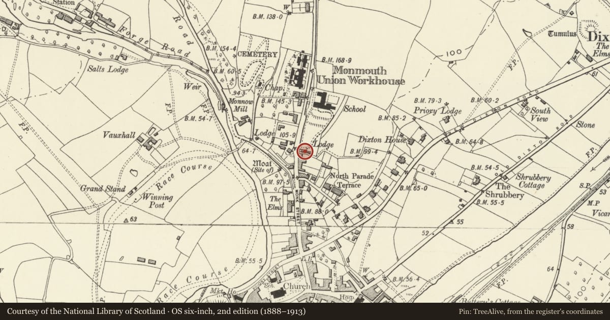
Slide toward Today to fade the historical sheet and see the modern map underneath.
David Rumsey Map Collection, Stanford LibrariesDavid Rumsey Map Collection, Stanford LibrariesDavid Rumsey Map Collection, Stanford LibrariesDavid Rumsey Map Collection, Stanford LibrariesDavid Rumsey Map Collection, Stanford Libraries
5 historical maps cover this location, the earliest the 1636 map "Cornubia : Devonia, Somersetus, Dorcestria, Wiltonia, Glocestria ..." (David Rumsey Map Collection, Stanford Libraries).
Historical maps covering this location
- 1636 · Cornubia : Devonia, Somersetus, Dorcestria, Wiltonia, Glocestria ... (David Rumsey Map Collection, Stanford Libraries)
- 1830 · V.3:11-15:XV.Britisches Reich. A. Kon: England. a. England ab sich: Shire:15-17, 33 (David Rumsey Map Collection, Stanford Libraries)
- 1895 · Sheet 11. Ordnance Survey of England and Wales. (David Rumsey Map Collection, Stanford Libraries)
- 1896 · 233 Monmouth (Hills) (David Rumsey Map Collection, Stanford Libraries)
- 1901 · Sheet 14. (David Rumsey Map Collection, Stanford Libraries)
Cadw's description
Location
On east side of road, at lower entrance to the school grounds, about 200m south of main school building.
History
Contemporary with the main school building which was opened formally on 25th October 1897; architect Henry Stock. The lodge has been little altered since.
Exterior
Squared red-brown sandstone rubble with Bath stone dressings, tile-hung first floor; plain-tiled roof with stone chimneys. Group consisting of lodge with attached gates and piers. Two storey lodge L-shaped backs onto lane to south. Generally mullion-and-transom windows. Main block has, facing north, an advanced gabled block with 3-light mullion-and-transom window in slightly projecting oriel; ground floor open to form two bays of verandah which extends to left in front of recessed single-storey block with a further two bays, verandah on timber posts standing on dwarf wall. To right of gable, in angle, further bay of verandah with curving tiled roof covering entrance doorway. Ground floor to right has 2-light window. West end has 3-light mullion-and-transom window to each floor, the upper one again in a slight oriel. The rear elevation has a roughly central gable with 2-light window on upper floor, 2-light window below. To left, 2-light window set across storeys, small mullioned window below. To right of gable, slightly advanced one-window block with tall stone chimney and stepped parapet.
Interior
Not inspected at resurvey.
Reason for designation
Included for its special interest as a well-preserved group of late C19 school lodge, gatepiers and gates which have definite character. Group value with listed main building at school.
Nearby in the register
- Entrance Screen, Gates and Gatepiers to Haberdashers' Monmouth School for GirlsEducationunder 1 mi
- 20 Hereford RoadNo class recordedunder 1 mi
- 18 Hereford RoadNo class recordedunder 1 mi
- 16 Hereford RoadNo class recordedunder 1 mi
Other entries of the same register within about three miles of this one, by straight line.