Cof Cymru: National Historic Assets of Wales · Wales
Plas Gywair
Llangywer, Gwynedd, Wales
A Grade II listed building in Llangower, Bala, Llangywer, Gwynedd, designated on 31 January 2005.
The record
- Designation
- Listed building, Grade II
- Broad class
- Domestic
- Date of designation
- 31 January 2005
- Locality
- Llangower, Bala
- Community
- Llangywer
- Unitary authority
- Gwynedd
- Country
- Wales
- Coordinates
- 52.87581, -3.62956
- Cadw reference
- 83589
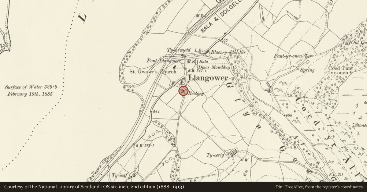
Slide toward Today to fade the historical sheet and see the modern map underneath.
David Rumsey Map Collection, Stanford LibrariesDavid Rumsey Map Collection, Stanford LibrariesLlyfrgell Genedlaethol Cymru – The National Library of WalesDavid Rumsey Map Collection, Stanford LibrariesDavid Rumsey Map Collection, Stanford Libraries
5 historical maps cover this location, the earliest the 1795 map "To Sir Watkin Williams-Wynn Bart ... the map of the six counties of North Wales is most humbly inscribed by his obedient humble servant" (Llyfrgell Genedlaethol Cymru – The National Library of Wales).
Historical maps covering this location
- 1795 · To Sir Watkin Williams-Wynn Bart ... the map of the six counties of North Wales is most… (Llyfrgell Genedlaethol Cymru – The National Library of Wales)
- 1830 · V.3:11-15:XV. Britisches Reich. A. Kon: England. b. Frstenthum Wales: Shire: 37-40 (David Rumsey Map Collection, Stanford Libraries)
- 1883 · Watershed map England, Wales 3. (David Rumsey Map Collection, Stanford Libraries)
- 1899 · 136 Bala (Hills) (David Rumsey Map Collection, Stanford Libraries)
- 1901 · Sheet 9 and 10. (David Rumsey Map Collection, Stanford Libraries)
Cadw's description
Location
Located in the hamlet of Llangower, in an elevated position above the B4403 and at the junction with a minor country road leading to Pantymarch.
History
Probably late C18 farmhouse and former rectory, possibly built when the church of St. Gwawr was rebuilt/restored. Recorded in the tithe apportionment of the parish as the Rectory, occupied by Reverend Hugh Jones. The house has been substantially altered internally in the latter part of the C20; the interior features (including several walls) were removed when the property was purchased in the 1970s and then changed again in 1991, when some of the internal walls were re-instated, the porch was also added at this date. Two C19 farm ranges to N of house.
Exterior
Two storey Georgian rectory, roughly square in plan and with storeyed wing at the rear (S) corner. Built of rubble masonry, the principal range, which overlooks the lake to NW, roughly coursed and with large stones as quoins and lintels. Shallow pitched hipped slate roof with advanced eaves and verges; large stone stacks with dripstones and capping. The principal elevation is a 2-window range with 16-pane hornless sash windows, the 1st floor windows under gabled half dormers; there are similar windows in the lateral walls. The entrance is to the R (NE) end of the rear wall, under a single pitched modern porch with lancet windows to each lateral wall. There is scattered fenestration across the rear elevation, a mix of styles including a small paned sash above the porch, a round headed leaded light stair window and several modern timber casements.
Interior
The interior could not be inspected at the time of the survey but is said, by the present owner, to have been substantially altered in recent years.
Reason for designation
Listed as a Georgian rectory which retains a good traditional character in the retention of plan, form and much original fenestration, particularly in the principal elevation.
Nearby in the register
- Church of St. GwawrReligious, Ritual and Funeraryunder 1 mi
- Pont LlangowerTransportunder 1 mi
- Ty-CerrigDomesticunder 1 mi
- FfynnongowerDomesticunder 1 mi
Other entries of the same register within about three miles of this one, by straight line.