Cof Cymru: National Historic Assets of Wales · Wales
Clydach Aqueduct on Tennant Canal
Dyffryn Clydach, Neath Port Talbot, Wales
A Grade II listed building in Neath Abbey, Neath, Dyffryn Clydach, Neath Port Talbot, designated on 22 December 2003.
The record
- Designation
- Listed building, Grade II
- Broad class
- Transport
- Date of designation
- 22 December 2003
- Locality
- Neath Abbey
- Town
- Neath
- Community
- Dyffryn Clydach
- Unitary authority
- Neath Port Talbot
- Country
- Wales
- Coordinates
- 51.66023, -3.82483
- Cadw reference
- 82339
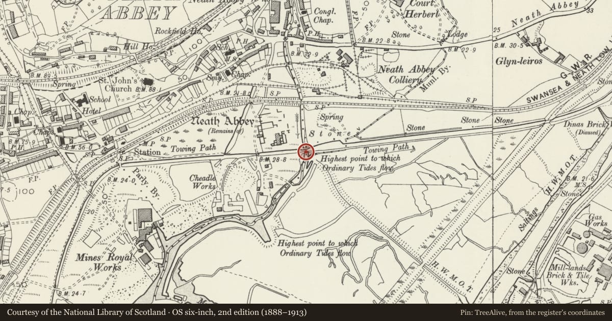
Slide toward Today to fade the historical sheet and see the modern map underneath.
David Rumsey Map Collection, Stanford LibrariesDavid Rumsey Map Collection, Stanford LibrariesDavid Rumsey Map Collection, Stanford LibrariesDavid Rumsey Map Collection, Stanford LibrariesDavid Rumsey Map Collection, Stanford Libraries
5 historical maps cover this location, the earliest the 1636 map "Cornubia : Devonia, Somersetus, Dorcestria, Wiltonia, Glocestria ..." (David Rumsey Map Collection, Stanford Libraries).
Historical maps covering this location
- 1636 · Cornubia : Devonia, Somersetus, Dorcestria, Wiltonia, Glocestria ... (David Rumsey Map Collection, Stanford Libraries)
- 1637 · The fourth table of England. Cornub. Devonia, Somerset etc. (David Rumsey Map Collection, Stanford Libraries)
- 1865 · England and Wales. England No. 6. (David Rumsey Map Collection, Stanford Libraries)
- 1891 · Sheet 10. Ordnance Survey of England and Wales. . (David Rumsey Map Collection, Stanford Libraries)
- 1897 · 247 Swansea (Hills) (David Rumsey Map Collection, Stanford Libraries)
Cadw's description
Location
Situated crossing the River Clydach just SE of Neath Abbey ruins.
History
Canal aqueduct built 1821 to carry the Tennant Canal over the River Clydach. The engineer was William Kirkhouse and the associated sluices on the SW side were part of the ill-fated Neath floating dock scheme. The canal opened in 1824 from the Neath Canal at Aberdulais to Port Tennant, Swansea. Traffic declined from the 1860s due to competition with railways but the canal did not close to commercial traffic until 1934.
Exterior
Canal aqueduct, rubble stone, two arches with cutwater between. Arches are segmental with thin stone voussoirs. On S side are rubble stone parapets with coping of curved slag blocks to centre and abutments splayed out each side in quadrant curves. To W is sluice gate with sandstone steps through right angle to river and rusticated pillars. No parapets on N side which is heavily repaired with cement.
Reason for designation
Included as a major historic feature of an important Welsh canal.
Nearby in the register
- Bridge over River Clydach to S of Neath AbbeyTransportunder 1 mi
- Bridge over Tennant Canal to S of entrance to Neath AbbeyTransportunder 1 mi
- Neath AbbeyAbbeyunder 1 mi
- The Smiths ArmsCommercialunder 1 mi
Other entries of the same register within about three miles of this one, by straight line.