Cof Cymru: National Historic Assets of Wales · Wales
Taff Vale Railway Bridge at Abercynon
Abercynon, Rhondda Cynon Taff, Wales
A Grade II listed building in Abercynon, Rhondda Cynon Taff, designated on 12 December 2002.
The record
- Designation
- Listed building, Grade II
- Broad class
- No class recorded
- Date of designation
- 12 December 2002
- Locality
- Abercynon
- Community
- Abercynon
- Unitary authority
- Rhondda Cynon Taff
- Country
- Wales
- Coordinates
- 51.64550, -3.32594
- Cadw reference
- 80763
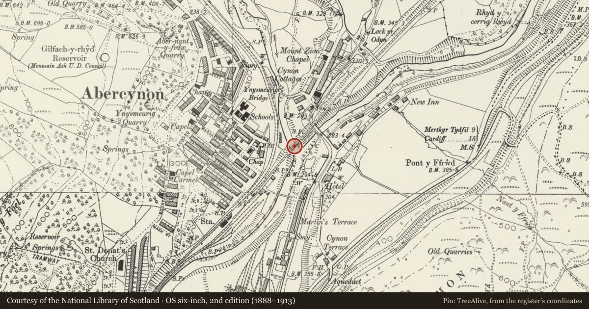
Slide toward Today to fade the historical sheet and see the modern map underneath.
David Rumsey Map Collection, Stanford LibrariesDavid Rumsey Map Collection, Stanford LibrariesDavid Rumsey Map Collection, Stanford LibrariesDavid Rumsey Map Collection, Stanford LibrariesDavid Rumsey Map Collection, Stanford Libraries
5 historical maps cover this location, the earliest the 1636 map "Cornubia : Devonia, Somersetus, Dorcestria, Wiltonia, Glocestria ..." (David Rumsey Map Collection, Stanford Libraries).
Historical maps covering this location
- 1636 · Cornubia : Devonia, Somersetus, Dorcestria, Wiltonia, Glocestria ... (David Rumsey Map Collection, Stanford Libraries)
- 1637 · The fourth table of England. Cornub. Devonia, Somerset etc. (David Rumsey Map Collection, Stanford Libraries)
- 1865 · England and Wales. England No. 6. (David Rumsey Map Collection, Stanford Libraries)
- 1895 · Sheet 11. Ordnance Survey of England and Wales. (David Rumsey Map Collection, Stanford Libraries)
- 1906 · 249 Newport (Hills) (David Rumsey Map Collection, Stanford Libraries)
Cadw's description
Location
Crossing Afon Cynon very near its confluence with Afon Taf, immediately E of the town.
History
The Taff Vale Railway was the original and leading independent railway of the region, opening up access between the iron and coal-producing Valleys and Cardiff, with its main outlet on Bute West Dock. The congestion on the Glamorganshire Canal of the 1830s was the stimulus and its promoters were ironmasters Sir John Josiah Guest head of Dowlais Ironworks and Walter Coffin who developed coal-mining in the Rhondda. It was engineered by Isambard Kingdom Brunel and received Royal Assent in 1836. The Cardiff to Navigation House at Abercynon section opened in 1840, onward to Merthyr in 1841. At first a single track, the doubling to Navigation House was achieved in 1847. The original line is 24.5 miles (39.4 km) long; it subsequently developed a number of branches. The route in this area follows the left bank of the Taff, here crossing the River Cynon. A short distance to N the line also crossed the former Glamorganshire Canal where an aqueduct took the canal over the River Taff, in the area still overlooked by the Navigation House Hotel. This was an important centre with Navigation House formerly housing the company offices, one of the major canal feeders entering from the NE and The Basin sited to N. North of Abercynon, the original railway route was through a tunnel to Incline Top; this was demolished in 1864 and replaced by a cutting. A comparison between the Tithe Map of 1842 and the First Edition OS map 1875 shows adjustments made to the line at Abercynon; these took place in 1861.
Exterior
A skewed railway bridge of two unequal arches. Built of coursed rock-faced stone, incorporating the conglomerate Radyr stone in the rounded coping to the parapet. Voussoirs extend round the complete arch to the base of the river pier and abutments; projecting course at track level. Three tiers of horizontal railings. Arch to N is taller and wider.
Reason for designation
Listed as a large river bridge of the historically pioneering Taff Vale Railway.
Nearby in the register
- Memorial ClockNo class recordedunder 1 mi
- Lock HouseDomesticunder 1 mi
- Quakers Yard Railway ViaductTransport1 mi
- Victoria Bridge, Penydarren TramroadNo class recorded1 mi
Other entries of the same register within about three miles of this one, by straight line.