Cof Cymru: National Historic Assets of Wales · Wales
Merrion Court
Castlemartin, Pembrokeshire, Wales
A Grade II listed building in Warren, Castlemartin, Pembrokeshire, designated on 14 May 1970.
The record
- Designation
- Listed building, Grade II
- Broad class
- Domestic
- Date of designation
- 14 May 1970
- Locality
- Warren
- Community
- Castlemartin
- Unitary authority
- Pembrokeshire
- Country
- Wales
- Coordinates
- 51.63562, -4.98095
- Cadw reference
- 6034
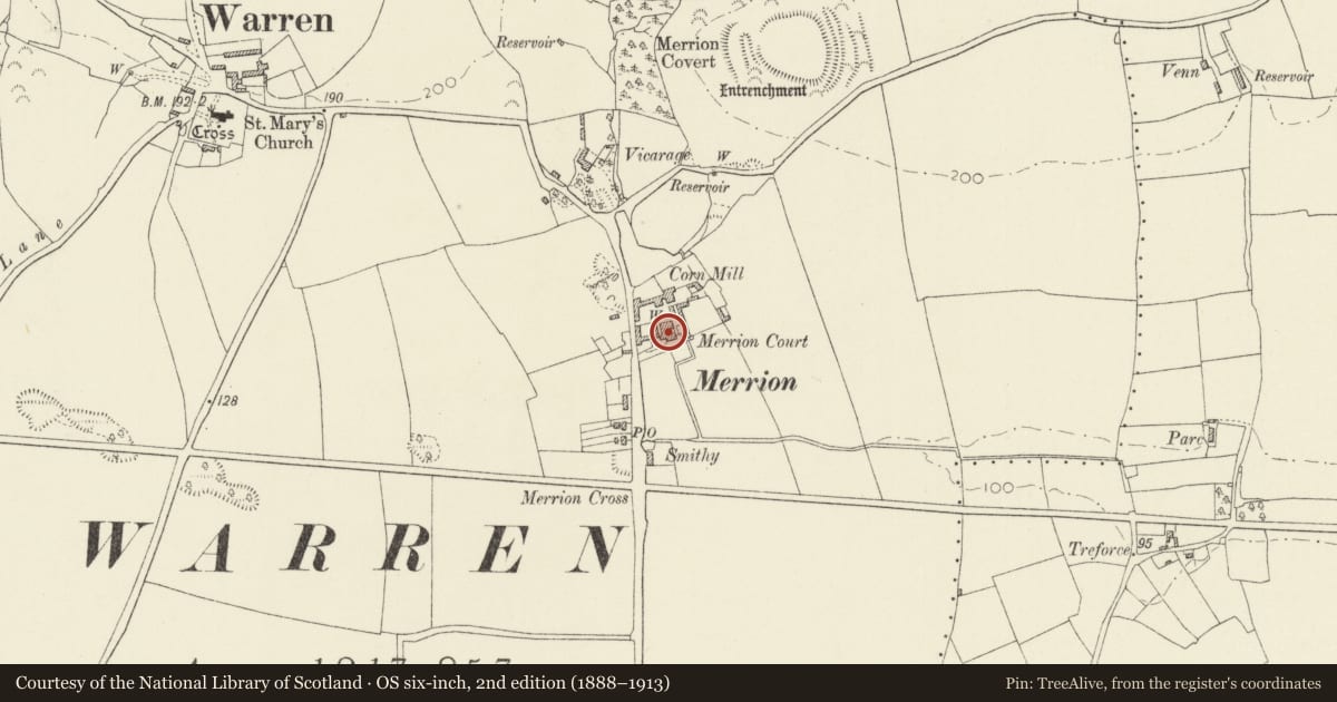
Slide toward Today to fade the historical sheet and see the modern map underneath.
David Rumsey Map Collection, Stanford LibrariesDavid Rumsey Map Collection, Stanford LibrariesDavid Rumsey Map Collection, Stanford LibrariesDavid Rumsey Map Collection, Stanford LibrariesDavid Rumsey Map Collection, Stanford Libraries
5 historical maps cover this location, the earliest the 1636 map "Cornubia : Devonia, Somersetus, Dorcestria, Wiltonia, Glocestria ..." (David Rumsey Map Collection, Stanford Libraries).
Historical maps covering this location
- 1636 · Cornubia : Devonia, Somersetus, Dorcestria, Wiltonia, Glocestria ... (David Rumsey Map Collection, Stanford Libraries)
- 1637 · The fourth table of England. Cornub. Devonia, Somerset etc. (David Rumsey Map Collection, Stanford Libraries)
- 1865 · England and Wales. England No. 6. (David Rumsey Map Collection, Stanford Libraries)
- 1891 · Sheet 10. Ordnance Survey of England and Wales. . (David Rumsey Map Collection, Stanford Libraries)
- 1898 · 245 Pembroke (Hills) (David Rumsey Map Collection, Stanford Libraries)
Cadw's description
Location
0.2 km N of Merrion Army Camp.
Exterior
History: Fenton in 1811 describes Merrion Court as a manor belonging to Lord Cawdor, in ruins. The new house and farm may date from about the time when leased to Lieut. Brown in 1820.
House: Early C19 house facing S with a rear wing and outbuildings. Single storey extension at W. The house two storeys, three windows range. A central arch-headed doorway, within a large hipped-roofed porch with window at front and external door at W. Recessed sash windows without horns, three and six pane sashes above, six pane sashes beneath. Thin glazing bars. Rubble masonry with rough-cast render, except for corners and window surrounds which are edged with smooth render. Hipped roof in asbestos slates. End chimneys. A large chimney at W has been further widened with an additional flue. Rear wing also has sash windows, one tucked partly behind the main range rear wall, the main range having been deepened subsequently by about 2 m.
Outbuildings: A small courtyard at rear with dairy at N. Barred windows to the dairy. At the angle where the rear wing of the house meets the dairy block there is a corn drying kiln with a drying floor and a granary with hopper above. Stable and pigeon-loft to N.
Good quality house of an important tenant holding on the Stackpole Estate, with interesting outbuildings.
References: Fenton, Historical Tour through Pembrokeshire 1811 (1903 ed.) 223
Howells, Pembrokeshire County History IV (1993) 81
Nearby in the register
- Outbuildings to Merrion CourtAgriculture and Subsistenceunder 1 mi
- Merrion Court Granary Range and MillIndustrialunder 1 mi
- Merrion CampEnclosureunder 1 mi
- Cross in St. Mary's ChurchyardReligious, Ritual and Funeraryunder 1 mi
Other entries of the same register within about three miles of this one, by straight line.