Cof Cymru: National Historic Assets of Wales · Wales
Maes Caled
Dolgellau, Gwynedd, Wales
A Grade II listed building in Dolgellau, Gwynedd, designated on 19 June 1990.
The record
- Designation
- Listed building, Grade II
- Broad class
- Domestic
- Date of designation
- 19 June 1990
- Community
- Dolgellau
- Unitary authority
- Gwynedd
- Country
- Wales
- Coordinates
- 52.74182, -3.89313
- Cadw reference
- 5105
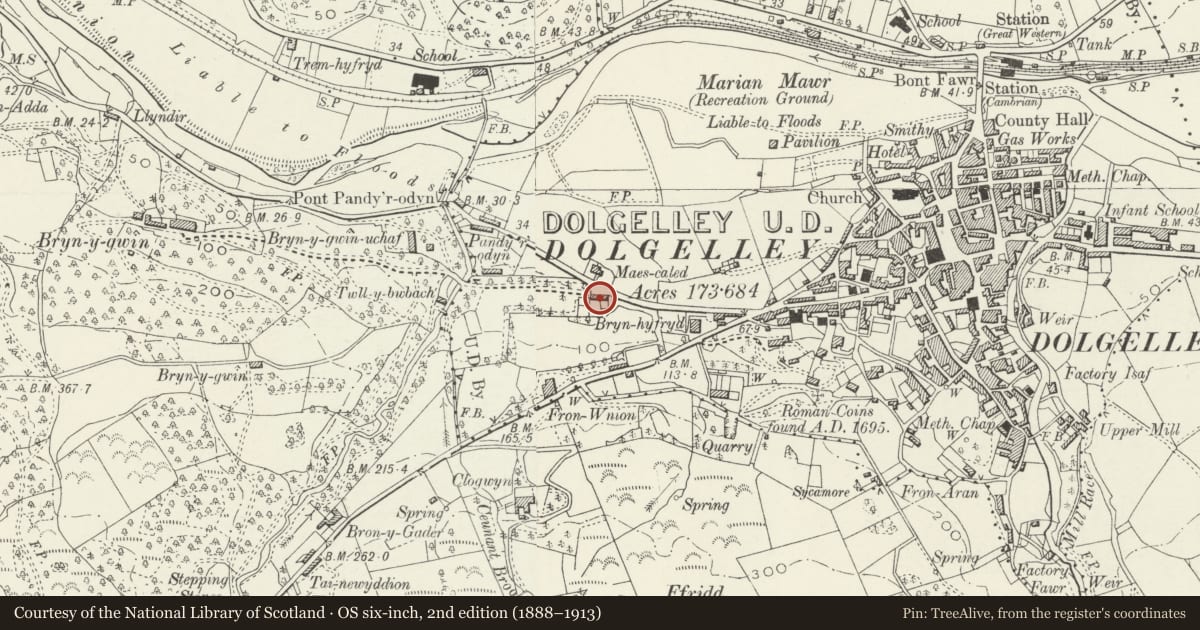
Slide toward Today to fade the historical sheet and see the modern map underneath.
David Rumsey Map Collection, Stanford LibrariesDavid Rumsey Map Collection, Stanford LibrariesLlyfrgell Genedlaethol Cymru – The National Library of WalesDavid Rumsey Map Collection, Stanford LibrariesDavid Rumsey Map Collection, Stanford Libraries
5 historical maps cover this location, the earliest the 1795 map "To Sir Watkin Williams-Wynn Bart ... the map of the six counties of North Wales is most humbly inscribed by his obedient humble servant" (Llyfrgell Genedlaethol Cymru – The National Library of Wales).
Historical maps covering this location
- 1795 · To Sir Watkin Williams-Wynn Bart ... the map of the six counties of North Wales is most… (Llyfrgell Genedlaethol Cymru – The National Library of Wales)
- 1830 · V.3:11-15:XV. Britisches Reich. A. Kon: England. b. Frstenthum Wales: Shire: 37-40 (David Rumsey Map Collection, Stanford Libraries)
- 1883 · Watershed map England, Wales 3. (David Rumsey Map Collection, Stanford Libraries)
- 1896 · Sheet 7. Ordnance Survey of England and Wales. (David Rumsey Map Collection, Stanford Libraries)
- 1901 · Sheet 9 and 10. (David Rumsey Map Collection, Stanford Libraries)
Cadw's description
Location
Set back from the main Towyn Road along the line of the former drive to Bryn-yr-Odyn.
History
l832 with Cl8 origins. Currently 3 cottages, that on the right formerly being the lodge to Bryn-yr-Odyn.
Exterior
l+ storey, 3 window elevation with gable to centre. Coursed rubble masonry. Moderately pitched slate roof, deep eaves and exposed purlins on brackets with corbels. Twin diagonal stone flue stacks on rectangular base, water tabling.
Raking dormer to left, 2 light casement windows. Canted oriel to gable, moulded stone bracket, fishscale slate roof, modern glazing. Victorian Gothic open gabled timber porch on stone sidewalls to centre. Paired Tudor arches, billet moulded tie-beam, scalloped bargeboards, fishscale slates. Paired, diagonally planked Victorian doors with decorative straps. Moulded returned label over 3 round arched lights to dressed stone window at left. Similar label over modern window to right. Similar 2 light dressed stone to extreme right.
Cambered arched 3 light window to right gable end, round arched lights. Ashlar closed porch to left. Shouldered gable parapet on kneelers over pointed doorway, with l832 datestone to apex. Fishscale slate roof, 2álight mullion and transom window to right, label. Ashlar gatepiers with stepped caps to former gateway at left.
Reason for designation
Group value with Nos l and 2 adjoining.
Nearby in the register
- Maes CaledDomesticunder 1 mi
- Maes CaledDomesticunder 1 mi
- Maes CaledDomesticunder 1 mi
- Maes CaledDomesticunder 1 mi
Other entries of the same register within about three miles of this one, by straight line.