Cof Cymru: National Historic Assets of Wales · Wales
Bryn Mair
Dolgellau, Gwynedd, Wales
A Grade II listed building in Dolgellau, Gwynedd, designated on 19 June 1990.
The record
- Designation
- Listed building, Grade II
- Broad class
- Domestic
- Date of designation
- 19 June 1990
- Community
- Dolgellau
- Unitary authority
- Gwynedd
- Country
- Wales
- Coordinates
- 52.74108, -3.88829
- Cadw reference
- 5024
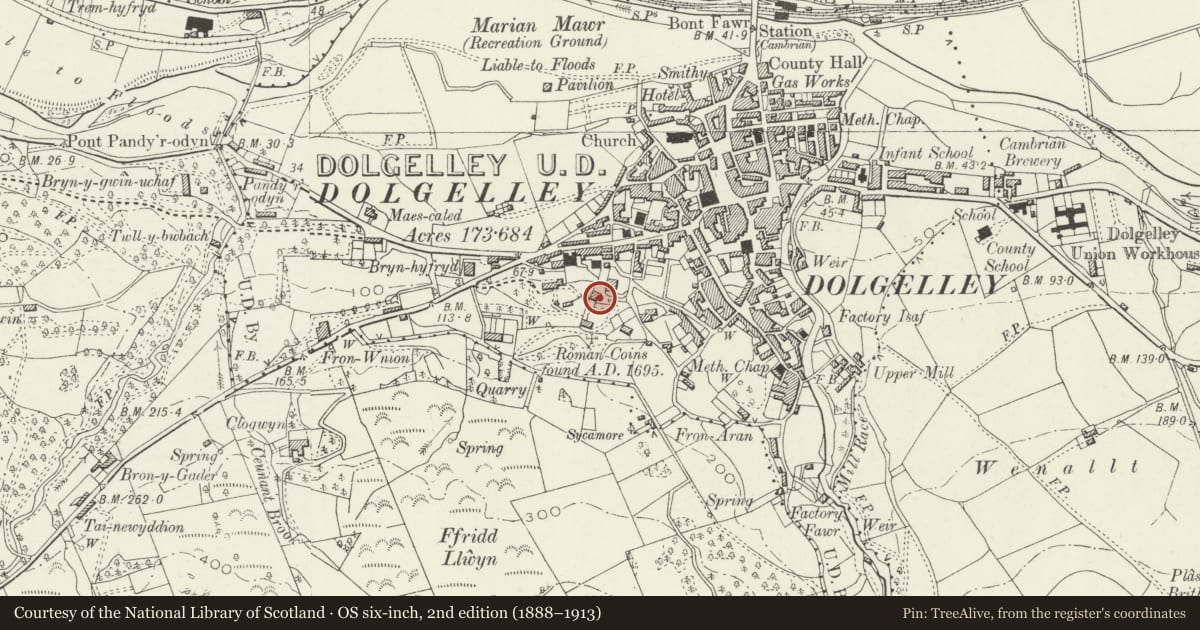
Slide toward Today to fade the historical sheet and see the modern map underneath.
David Rumsey Map Collection, Stanford LibrariesDavid Rumsey Map Collection, Stanford LibrariesLlyfrgell Genedlaethol Cymru – The National Library of WalesDavid Rumsey Map Collection, Stanford LibrariesDavid Rumsey Map Collection, Stanford Libraries
5 historical maps cover this location, the earliest the 1795 map "To Sir Watkin Williams-Wynn Bart ... the map of the six counties of North Wales is most humbly inscribed by his obedient humble servant" (Llyfrgell Genedlaethol Cymru – The National Library of Wales).
Historical maps covering this location
- 1795 · To Sir Watkin Williams-Wynn Bart ... the map of the six counties of North Wales is most… (Llyfrgell Genedlaethol Cymru – The National Library of Wales)
- 1830 · V.3:11-15:XV. Britisches Reich. A. Kon: England. b. Frstenthum Wales: Shire: 37-40 (David Rumsey Map Collection, Stanford Libraries)
- 1883 · Watershed map England, Wales 3. (David Rumsey Map Collection, Stanford Libraries)
- 1896 · Sheet 7. Ordnance Survey of England and Wales. (David Rumsey Map Collection, Stanford Libraries)
- 1901 · Sheet 9 and 10. (David Rumsey Map Collection, Stanford Libraries)
Cadw's description
Location
Set away from the Lane in its own grounds, reached via a drive just S of where Bryn Teg meets Love Lane.
History
l838.
Exterior
3 storey and cellar, 2 window house. Coursed, squared rubble masonry. Gently pitched quarry slate roof. Deep boarded eaves and verges. Ashlar stacks, flues grouped on bases, moulded caps.
Right hand gabled bay advanced, with narrow outshot to centre, gablet to left. l6 pane sash windows to 2nd floor; 20 pane sashes to lst floor, stone lintels 20 pane sash to ground floor right. Original doorway obscured by modern single storey, flat roofed, stone extension. Victorian sashes to side of central outshot.
Garden front similar with broader advanced gabled bay to right, gablet to left. l6 pane sash windows to 2nd floor; 20 pane sashes to lst floor, stone lintels. Glazing bars removed to sash window at ground floor right.
Canted bay with corniced top to left, l2 pane front sash, narrow sash side lights.
Rear elevation with outshot to centre housing staircase, gabled dormer to roof over.
Narrow alley alongside left side of house, slate slabs to hillside form roof, originally 2 storey, contained privy's etc. Entrance doorway off hillside at 2nd floor level, gabled hood on brackets.
Interior
Depressed hall arch, panelled soffit and pilasters. Good contemporary stair, square newels, strapwork finials and pendants, alternating turned and sinuous balusters, moulded tread ends. 6 panel doors, deep panelled splays, moulded architraves. Panelled shutters, chimneypieces, buffet recess.
Nearby in the register
- Coach House to Bryn MairDomesticunder 1 mi
- Stable Tables & Loose Box to Bryn MairDomesticunder 1 mi
- Gatepiers & Walls to entrance to Bryn MairDomesticunder 1 mi
- Gates to BrynffynnonDomesticunder 1 mi
Other entries of the same register within about three miles of this one, by straight line.