Cof Cymru: National Historic Assets of Wales · Wales
Old Board School at Llawrybettws
Llandderfel, Gwynedd, Wales
A Grade II listed building in Glan-yr-Afon, Bala, Llandderfel, Gwynedd, designated on 20 October 1966.
The record
- Designation
- Listed building, Grade II
- Broad class
- Domestic
- Date of designation
- 20 October 1966
- Locality
- Glan-yr-Afon
- Town
- Bala
- Community
- Llandderfel
- Unitary authority
- Gwynedd
- Country
- Wales
- Coordinates
- 52.97112, -3.45415
- Cadw reference
- 4664
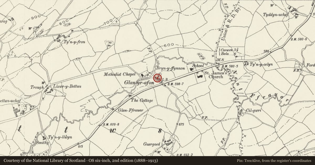
Slide toward Today to fade the historical sheet and see the modern map underneath.
David Rumsey Map Collection, Stanford LibrariesDavid Rumsey Map Collection, Stanford LibrariesLlyfrgell Genedlaethol Cymru – The National Library of WalesDavid Rumsey Map Collection, Stanford LibrariesDavid Rumsey Map Collection, Stanford Libraries
5 historical maps cover this location, the earliest the 1795 map "To Sir Watkin Williams-Wynn Bart ... the map of the six counties of North Wales is most humbly inscribed by his obedient humble servant" (Llyfrgell Genedlaethol Cymru – The National Library of Wales).
Historical maps covering this location
- 1795 · To Sir Watkin Williams-Wynn Bart ... the map of the six counties of North Wales is most… (Llyfrgell Genedlaethol Cymru – The National Library of Wales)
- 1830 · V.3:11-15:XV. Britisches Reich. A. Kon: England. b. Frstenthum Wales: Shire: 37-40 (David Rumsey Map Collection, Stanford Libraries)
- 1883 · Watershed map England, Wales 3. (David Rumsey Map Collection, Stanford Libraries)
- 1898 · 120 Corwen (Hills) (David Rumsey Map Collection, Stanford Libraries)
- 1901 · Sheet 9 and 10. (David Rumsey Map Collection, Stanford Libraries)
Cadw's description
Location
In the centre of the small village group, on the E side of the lane.
History
Early C19 school hall, formerly the Old Board School of Llawrybettws.
Exterior
Tall, single-storeyed rectangular former school hall. Of local rubble construction (originally rendered) with old slate roof and tiled ridge; plain bargeboards and projecting verges to the R gable; modern wire netting. The building has 3 segmentally-arched windows to each side, with projecting sills and rough-dressed voussoirs; these have labels made of narrow stones in the local vernacular fashion. The R gable end has a shallow projecting chimney with reduced stack; segmentally-arched, deeply-recessed entrance to the L; single arched window to the L gable, as before. All openings were boarded up at the time of survey.
Interior
The interior was not inspected at the time of survey, though is recorded as having a King Post and tie beam roof.
Reason for designation
Listed for its special interest as an early C19 former village school.
Nearby in the register
- Llawrybettws ChapelReligious, Ritual and Funeraryunder 1 mi
- Church of Saint James the GreatReligious, Ritual and Funeraryunder 1 mi
- Barn at Ty MawrAgriculture and Subsistenceunder 1 mi
- Ty MawrDomesticunder 1 mi
Other entries of the same register within about three miles of this one, by straight line.