Cof Cymru: National Historic Assets of Wales · Wales
Lodge, formerly for Brynkir
Dolbenmaen, Gwynedd, Wales
A Grade II listed building in Brynkir, Dolbenmaen, Gwynedd, designated on 19 October 1971.
The record
- Designation
- Listed building, Grade II
- Broad class
- Domestic
- Date of designation
- 19 October 1971
- Locality
- Brynkir
- Town
- Dolbenmaen
- Community
- Dolbenmaen
- Unitary authority
- Gwynedd
- Country
- Wales
- Coordinates
- 52.96691, -4.20639
- Cadw reference
- 4289
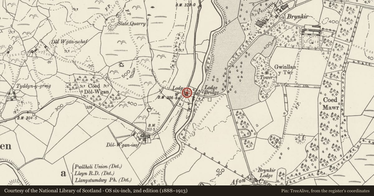
Slide toward Today to fade the historical sheet and see the modern map underneath.
David Rumsey Map Collection, Stanford LibrariesDavid Rumsey Map Collection, Stanford LibrariesLlyfrgell Genedlaethol Cymru – The National Library of WalesDavid Rumsey Map Collection, Stanford LibrariesDavid Rumsey Map Collection, Stanford Libraries
5 historical maps cover this location, the earliest the 1795 map "To Sir Watkin Williams-Wynn Bart ... the map of the six counties of North Wales is most humbly inscribed by his obedient humble servant" (Llyfrgell Genedlaethol Cymru – The National Library of Wales).
Historical maps covering this location
- 1795 · To Sir Watkin Williams-Wynn Bart ... the map of the six counties of North Wales is most… (Llyfrgell Genedlaethol Cymru – The National Library of Wales)
- 1830 · V.3:11-15:XV. Britisches Reich. A. Kon: England. b. Frstenthum Wales: Shire: 37-40 (David Rumsey Map Collection, Stanford Libraries)
- 1883 · Watershed map England, Wales 3. (David Rumsey Map Collection, Stanford Libraries)
- 1896 · Sheet 7. Ordnance Survey of England and Wales. (David Rumsey Map Collection, Stanford Libraries)
- 1901 · Sheet 9 and 10. (David Rumsey Map Collection, Stanford Libraries)
Cadw's description
Location
The lodge stands in the lower end of Cwm Pennant, on the W side of where the road from Golan crosses the Afon Dwyfor and in the angle of the road from Dolbenmaen.
History
The building was built by the Brynkir Estate in the early C19 as a lodge at the start of the driveway to old Brynkir Hall.
Exterior
Built in rubble stonework and painted white, with a low pitched hipped slate roof and wide eaves. Central chimney stack. Two storeys, 3 bays, a central boarded door and flanking casement windows with Gothick style intersecting iron glazing bars 4 lights wide, all recessed on the ground floor behind rubble segmental arches. On the first floor a blind central panel, and flanking 12-paned sash windows, all similarly recessed, their heads directly below the eaves. A service outshut along the full length of the rear.
Reason for designation
Included as a well-preserved lodge, a good specimen of the Gothick style applied to a park lodge, and fashionable at that period.
Nearby in the register
- Lodge BridgeTransportunder 1 mi
- Twr GwynllanGardens, Parks and Urban Spacesunder 1 mi
- Pont BrynkirTransportunder 1 mi
- MilestoneTransportunder 1 mi
Other entries of the same register within about three miles of this one, by straight line.