Cof Cymru: National Historic Assets of Wales · Wales
Bwthyn Rhosyn (Rose Cottage)
Llandwrog, Gwynedd, Wales
A Grade II listed building in Llandwrog, Caernarfon, Gwynedd, designated on 29 May 1968.
The record
- Designation
- Listed building, Grade II
- Broad class
- Domestic
- Date of designation
- 29 May 1968
- Locality
- Llandwrog
- Town
- Caernarfon
- Community
- Llandwrog
- Unitary authority
- Gwynedd
- Country
- Wales
- Coordinates
- 53.07895, -4.31338
- Cadw reference
- 3780
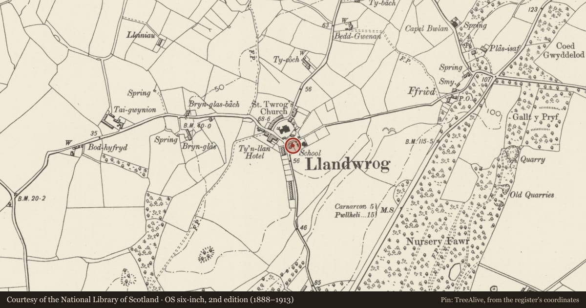
Slide toward Today to fade the historical sheet and see the modern map underneath.
David Rumsey Map Collection, Stanford LibrariesDavid Rumsey Map Collection, Stanford LibrariesDavid Rumsey Map Collection, Stanford LibrariesDavid Rumsey Map Collection, Stanford LibrariesLlyfrgell Genedlaethol Cymru – The National Library of Wales
5 historical maps cover this location, the earliest the 1795 map "To Sir Watkin Williams-Wynn Bart ... the map of the six counties of North Wales is most humbly inscribed by his obedient humble servant" (Llyfrgell Genedlaethol Cymru – The National Library of Wales).
Historical maps covering this location
- 1795 · To Sir Watkin Williams-Wynn Bart ... the map of the six counties of North Wales is most… (Llyfrgell Genedlaethol Cymru – The National Library of Wales)
- 1883 · Watershed map England, Wales 3. (David Rumsey Map Collection, Stanford Libraries)
- 1896 · Sheet 7. Ordnance Survey of England and Wales. (David Rumsey Map Collection, Stanford Libraries)
- 1899 · 118 Nevin (Hills) (David Rumsey Map Collection, Stanford Libraries)
- 1901 · Sheet 9 and 10. (David Rumsey Map Collection, Stanford Libraries)
Cadw's description
Location
Located in the centre of the village at T-junction immediately north-west of the school; rubblestone wall in front with stone-on-edge coping and iron gate.
History
The cottage is dated 1835 and appears to be one of the earliest of the buildings erected by the third Lord Newborough in the first phase of the replanning of Llandwrog as an estate village between the 1830s and c1860. Shown on 1840 Tithe Map.
Exterior
Single-storey cottage. Picturesque Gothic style typical of the earlier buildings in the replanned village. Irregularly coursed rubblestone with ashlar dressings to outer arch of porch and reddish brown brick window surrounds and chimney stacks; slate roof with coped verges and deep overhanging eaves with slate soffits. Central gabled porch with datestone "1835" above outer depressed pointed arch; ledged inner door with glazed panel to timber tympanum; 3-light timber mullioned and transomed window with cambered head and dripmould to either side of porch; integral end stacks and ridge stack to left of porch, all with rendered bases and moulded capping with chimney pots. Narrow lean-to and lower ranges to rear.
Interior
Interior not inspected at time of Survey.
Reason for designation
Included as a largely unaltered cottage of Picturesque style, forming an integral part of this important early Victorian planned village. Llandwrog is among the best-preserved such villages in this part of Wales from this period.
Nearby in the register
- Horse Drinking TroughWater Supply and Drainageunder 1 mi
- Caer EglwysDomesticunder 1 mi
- No.3 Tai'r Ysgol (School Cottages)Domesticunder 1 mi
- No.2 Tai'r Ysgol (School Cottages)Domesticunder 1 mi
Other entries of the same register within about three miles of this one, by straight line.