Cof Cymru: National Historic Assets of Wales · Wales
Former Stable Block of Drybridge House
Monmouth, Monmouthshire, Wales
A Grade II listed building in Overmonnow, Monmouth, Monmouthshire, designated on 6 March 1991.
The record
- Designation
- Listed building, Grade II
- Broad class
- Domestic
- Date of designation
- 6 March 1991
- Locality
- Overmonnow
- Town
- Monmouth
- Community
- Monmouth
- Unitary authority
- Monmouthshire
- Country
- Wales
- Coordinates
- 51.80919, -2.72315
- Cadw reference
- 2853
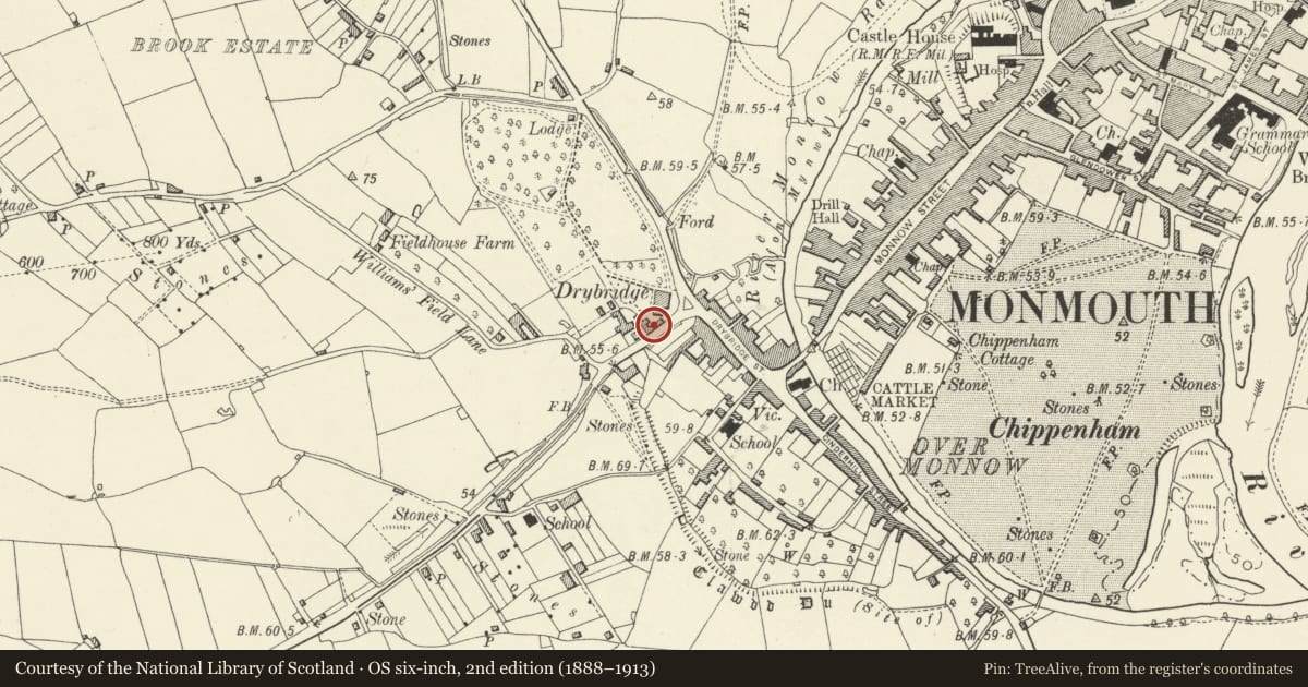
Slide toward Today to fade the historical sheet and see the modern map underneath.
David Rumsey Map Collection, Stanford LibrariesDavid Rumsey Map Collection, Stanford LibrariesDavid Rumsey Map Collection, Stanford LibrariesDavid Rumsey Map Collection, Stanford LibrariesDavid Rumsey Map Collection, Stanford Libraries
5 historical maps cover this location, the earliest the 1636 map "Cornubia : Devonia, Somersetus, Dorcestria, Wiltonia, Glocestria ..." (David Rumsey Map Collection, Stanford Libraries).
Historical maps covering this location
- 1636 · Cornubia : Devonia, Somersetus, Dorcestria, Wiltonia, Glocestria ... (David Rumsey Map Collection, Stanford Libraries)
- 1830 · V.3:11-15:XV.Britisches Reich. A. Kon: England. a. England ab sich: Shire:15-17, 33 (David Rumsey Map Collection, Stanford Libraries)
- 1895 · Sheet 11. Ordnance Survey of England and Wales. (David Rumsey Map Collection, Stanford Libraries)
- 1896 · 233 Monmouth (Hills) (David Rumsey Map Collection, Stanford Libraries)
- 1901 · Sheet 14. (David Rumsey Map Collection, Stanford Libraries)
Cadw's description
Location
Located along side road to Dingestow and forming side of service yard to south of main house.
History
Picturesque later C19 range of stables with lofts over, probably contemporary with the re-working of the house and thus c1867.
Exterior
Built of red brick in English bond with stone rubble plinth, Welsh slate roof. Partly two storeyed. Various windows including 3 over 6 pane sash, cross-gabled heads to boarded loading-doors, twin ground-floor doors. Roof with timber clock turret capped by hipped slate roof and weathervane. Vents to ends, moulded timber brackets to oversailing eaves. One-storey attached ranges with end finials, eaves as before; slender wallhead chimney over mullioned windows facing road. A further contemporary red brick building to north-west of group. Rear elevation not seen.
Interior
Interior not seen at resurvey.
Reason for designation
Included for its special interest as an outbuilding of definite character having group value with the associated Drybridge house.
Nearby in the register
- Bridges Community centre (formerly Drybridge House)Health and Welfareunder 1 mi
- 6 Drybridge TerraceNo class recordedunder 1 mi
- 7 Drybridge TerraceNo class recordedunder 1 mi
- 5 Drybridge TerraceNo class recordedunder 1 mi
Other entries of the same register within about three miles of this one, by straight line.