Cof Cymru: National Historic Assets of Wales · Wales
The Old Cider Mill
Wye Valley, Monmouthshire, Wales
A Grade II listed building in Tintern Parva, Chepstow, Wye Valley, Monmouthshire, designated on 31 August 1976.
The record
- Designation
- Listed building, Grade II
- Broad class
- Industrial
- Date of designation
- 31 August 1976
- Locality
- Tintern Parva
- Town
- Chepstow
- Community
- Wye Valley
- Unitary authority
- Monmouthshire
- Country
- Wales
- Coordinates
- 51.71280, -2.68880
- Cadw reference
- 2752
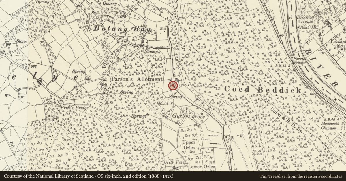
Slide toward Today to fade the historical sheet and see the modern map underneath.
David Rumsey Map Collection, Stanford LibrariesDavid Rumsey Map Collection, Stanford LibrariesDavid Rumsey Map Collection, Stanford LibrariesDavid Rumsey Map Collection, Stanford LibrariesDavid Rumsey Map Collection, Stanford Libraries
5 historical maps cover this location, the earliest the 1636 map "Cornubia : Devonia, Somersetus, Dorcestria, Wiltonia, Glocestria ..." (David Rumsey Map Collection, Stanford Libraries).
Historical maps covering this location
- 1636 · Cornubia : Devonia, Somersetus, Dorcestria, Wiltonia, Glocestria ... (David Rumsey Map Collection, Stanford Libraries)
- 1637 · The fourth table of England. Cornub. Devonia, Somerset etc. (David Rumsey Map Collection, Stanford Libraries)
- 1830 · V.3:11-15:XV.Britisches Reich. A. Kon: England. a. England ab sich: Shire:15-17, 33 (David Rumsey Map Collection, Stanford Libraries)
- 1895 · Sheet 11. Ordnance Survey of England and Wales. (David Rumsey Map Collection, Stanford Libraries)
- 1896 · 233 Monmouth (Hills) (David Rumsey Map Collection, Stanford Libraries)
Cadw's description
Location
By roadside 100m S of road junction to Botany Bay.
History
Probably an early to mid C19 cider mill which was converted into a house in the late 1970's and was given considerable extensions in matching stonework. It appears to be shown on the Tintern Parva Tithe Map which is dated 6/1846.
Exterior
The building is constructed of random sandstone rubble walls, with quoins to the original part and with a gabled concrete interlocking tile roof. Two storeys to the road with single storey wings on either side and a two storey rear wing. Road elevation with two window openings to upper floor and a similar window opening to left hand bay below. Ground floor doorway with small window opening to right hand. Concrete lintels to windows and late C20 stained timber joinery with 2-light casements. The wings either end have doors but no windows to the road. The rear wing is modern with two windows below and gabled half dormers.
Interior
Interior not seen at resurvey but the cider mill and press are still in situ in the ground floor room of the original cider mill.
Reason for designation
Included as an early to mid C19 cider mill with its machinery still intact despite the building having been converted into a house. The survival of cider making machinery in-situ is now extremely rare despite its former frequency in this area. Another mill survives in Tintern Community in the bar of The Anchor Hotel (qv).
Nearby in the register
- Early Iron Furnace at Coed-IthelBlast Furnaceunder 1 mi
- Former Cider House at Coed Ithel FarmAgriculture and Subsistenceunder 1 mi
- Three Round Barrows in Lower Hale WoodRound Cairnunder 1 mi
- Whitestone Direction MarkerTransportunder 1 mi
Other entries of the same register within about three miles of this one, by straight line.